Quantcast
Channel: Weekly – weekly – semanario – hebdo –週刊 – týdeník – Wochennotiz –주간 – tygodnik
Viewing all 417 articles
Browse latest View live

týdeník 608

$
0
0

Zatím není dostupné For the sake of viewer convenience, the content is shown below in this site default language. You may click one of the links to switch the site language to another available language.

08/03/2022-14/03/2022

lead picture

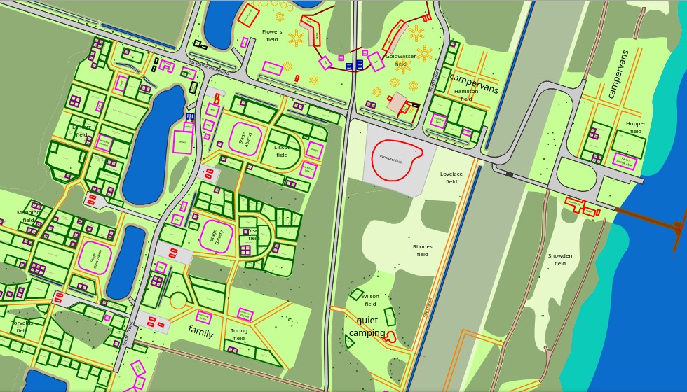
Barometer of cycle-friendly cities [1] © FUB | map data © OpenStreetMap contributors

Mapping campaigns

  • OSM Ghana tweeted statistics of their #28DaysMappingChallenge. In February OSM Ghana started a campaign to motivate people to make contributions to OSM on each day of the month. They garnered 598,386 edits from 69 contributors.
  • Becky Candy wrote about live validation during a mapathon.
  • Flanders Tourism launched a website to gather data on tourism POIs, such as: charging points for electric bikes, playgrounds, picnic tables and benches. This project, built upon MapComplete, entails a public campaign with a video presentation (de) and a data import . The developer gave a quick overview in his diary.
  • raphaelmirc presents (pt) > en MapSãoFrancisco, an initiative of Canoa de Tolda and InfoSãoFrancisco that aims to develop collaborative mapping projects throughout the São Francisco river basin (Brazil).
  • The new UMBRAOSM event will be held (pt) > en on Saturday 2 April, from 00:00 to 23:59 (UTC-3). It will be a mapathon focusing on buildings, roads, POIs, and green areas.

Mapping

  • Christoph Hormann presented his ‘TagDoc Project’, which is intended to offer an alternative to the OSM Wiki with the focus on the de facto use of tags.
  • The following proposals await your comments:
    • opening_hours:autism=* to facilitate people looking for autism friendly opening hours.
    • artwork_subject=sheela-na-gig to tag ‘Sheela-na-gigs’, stone carvings depicting nude women exposing their genitals, found on churches, castles, other walls and in museums.

Community

  • The Korea OSM community has decided (ko) > en to change Ukrainian OSM place names in Korean from Russian notation (e.g. 키예프 – as same ‘Kiev’, 하리코프 – as same ‘Kharkov’) to Ukrainian notation (e.g. 키이우 – as same ‘Kyiv’, 하르키우 – as same ‘Kharkiv’) and is currently editing OSM. The revision of the notation is based on the National Institute of Korean Language’s Ukrainian Geographical Names and Personal Information Collection (2022-03-11) (ko).
  • The OpenStreetMap Ops Team tweeted that the new Discourse based Community Forum has launched. The community is invited to participate in the next steps.
  • The OSM community of Burgos, Spain, is planning several activities, including a mapathon and talks on 1 and 2 April. More information on the event is available on the wiki (es) page.
  • OSM Fukushima members have released videos introducing weeklyOSM 603 and 604 (ja). After introducing weeklyOSM, they interviewed Hokkosha, one of the most active mappers in Japan.

OpenStreetMap Foundation

  • Paul Norman explained: the usage polices for Nominatim and OSM Map Tiles, automatic blocking, and how to fix too frequent requests.

Events

  • On Saturday 19 March, Maptime Bogota brought together (es) > en mappers virtually to update the representation of bike paths in OSM for the Colombian capital.
  • Thanks to C3VOC, video recordings from FOSSGIS 2022 are now available (de).
  • Save the date for Open Belgium 2022, which will be held on Friday 29 April at De Krook, in Ghent, as a real-life event. If you have an idea for a talk or workshop, submit it yourself or ask for advice on how to (deadline is Monday 21 March).

Education

OSM research

  • Datenschatz has written a detailed tutorial on how one can systematically identify and visualise missing data points in OSM data with the help of Pandas and a bit of geo-datascience. The data he is using to compare are health departments in Germany.
  • Transport researchers are studying how open data (such as OSM) stimulates digital civic engagement. One of them has asked mappers to participate in a five minute survey.

Maps

  • K. Sakanoshita has developed (ja) an online map to show historic objects in Ukraine.
  • [1] The Fédération française des Usagers de la Bicyclette (French National Cyclists Association) has published (fr) > en the results of the 2021, and third, edition of the ‘aromètre Parlons Vélo‘ which is a nationwide survey about bicycle usage. A general map shows (fr) > en the multiple cities ranking, while a second one shows (fr) > en locations perceived as problematic, improved or where a parking solution is needed.
  • Liveuamap has made an OSM based interactive map showing the latest news in Ukraine.

Open Data

Software

  • yuiseki has developed (ja) an online tool (ja) to assist in editing building address data. Currently, only Japanese addresses are supported, but he plans to support the entire world in the future. The source code is available on GitHub.
  • The Technical University of Darmstadt presented (de) the ‘Intermodal Travel Information’ Motis-Project on media.ccc.de. A demonstration application (de) and the sources are available.
  • RouteXL is a web appplication using OpenStreetMap data for road itinerary planning, with optimisation for multiple stops to save travel time and cost. It is free to use for routes of up to 20 stops. Various geocoders can be selected including Nominatim.
  • Strasbourg launched its mobile application StrasApp (fr) > en, which provides a map view to users through OpenMapTiles. Unfortunately, as has been noted (fr) > en, with a complete lack of attribution of either OpenMapTiles or OpenStreetMap as requested by the OpenMapTiler group.

Programming

  • Geofabrik presentedShortbread‘, a basic, lean, general-purpose vector tile schema for OpenStreetMap data, CC0/FTWPL licensed.
  • Sarah Hoffmann pointed out (de) > en that OpenStreetMap is participating in the Google Summer of Code as an organisation and the first project ideas for it have been made.

Releases

  • Vespucci’s March 2022 maintenance release 17.04 is now available in the Play Store.

Did you know …

  • BBBike Map Compare for comparing maps? You can use it find out if Waze uses OSM without attribution, for example.
  • … the new Twitter account OSMChangesets?

OSM in the media

  • Robert Goedl described (de) > en how to use Maperitive to edit OpenStreetMap maps on Linux.

Other “geo” things

  • In the era of phones and online navigation maps, the police emergency response to a shooting in rural Nova Scotia (Canada) showed that the police local units did not have a rapid and reliable backup system for road navigation and aerial images. They consulted an online map that provided road navigation results that seemed unreliable to people that knew the area.
  • contrapunctus asked on OSMIndia: ‘Does anyone know of any opportunities to be a full-time, professional OSM mapper?’. They received a number of accurate answers.

Upcoming Events

Where What Online When Country
臺北市 OpenStreetMap街景踏查團工作坊1 osmcalpic 2022-03-19 flag
Ciudad de Guatemala Primer mapatón YouthMappers en Guatemala (remoto) osmcalpic 2022-03-19 – 2022-03-20 gt
City of Subiaco Social Mapping Sunday: Shenton Park osmcalpic 2022-03-20 flag
Habay-la-Neuve Réunion des contributeurs OpenStreetMap, Habay-la-Neuve osmcalpic 2022-03-21 flag
OSMF Engineering Working Group meeting osmcalpic 2022-03-21
Why Open Data Matters for Cycling: Visualizing a Cycling City osmcalpic 2022-03-22
Barcelona Geomob Barcelona osmcalpic 2022-03-22 flag
City of Nottingham OSM East Midlands/Nottingham meetup (online) osmcalpic 2022-03-22 flag
Decatur County OSM US Mappy Hour osmcalpic 2022-03-24 flag
[Online] OpenStreetMap Foundation board of Directors – public videomeeting osmcalpic 2022-03-24
IJmuiden OSM Nederland bijeenkomst (online) osmcalpic 2022-03-26 flag
06060 Reunión Bimestral OSM-LatAm osmcalpic 2022-03-26 flag
Perth Social Mapping Online osmcalpic 2022-03-27 flag
Bremen Bremer Mappertreffen (Online) osmcalpic 2022-03-28 flag
San Jose South Bay Map Night osmcalpic 2022-03-30 flag
Ville de Bruxelles – Stad Brussel Virtual OpenStreetMap Belgium meeting osmcalpic 2022-03-29 flag
Tucson State of the Map US osmcalpic 2022-04-01 – 2022-04-03 flag
Burgos Evento OpenStreetMap Burgos (Spain) 2022 osmcalpic 2022-04-01 – 2022-04-03 flag
Stuttgart Stuttgarter Stammtisch osmcalpic 2022-04-05 flag
London Missing Maps London Mapathon osmcalpic 2022-04-05 flag
Berlin OSM-Verkehrswende #34 (Online) osmcalpic 2022-04-05 flag

Note:
If you like to see your event here, please put it into the OSM calendar. Only data which is there, will appear in weeklyOSM.

This weeklyOSM was produced by Lejun, Nordpfeil, PierZen, SK53, Sammyhawkrad, SomeoneElse, Strubbl, Ted Johnson, TheSwavu, YoViajo, derFred, jcr83, muramototomoya.[


týdeník 609

$
0
0

Zatím není dostupné For the sake of viewer convenience, the content is shown below in this site default language. You may click one of the links to switch the site language to another available language.

15/03/2022-21/03/2022

Mapping campaigns

  • UN Mappers are going to map building footprints, supporting UNSMIL to ensure peace in Libya, on Wednesday 30 March from 06:00 UTC until 16:00 UTC. The tasks will be distributed via the tasking manager.
  • Andrés Gómez Casanova announced that the note-a-thon (a group activity solving local notes in Latin American countries) will be held on the first Saturday of each month from now on. The note-a-thon is registered as an organised activity. See the details (es) > en of this activity on the wiki. Events are coordinated (es) > en on Meetup.

Mapping

  • bgo_eiu reported on his unexpected insights gained while trying to improve the mapping of Baltimore’s public transit in OSM.
  • Counter-mapping the City was a two day virtual conference about using mapping as a means of promoting the struggles of marginalised people in the Philippines.
  • dcapillae has started (es) > en an initiative with authorised mappers to improve the positions of recently imported recycling containers in Malaga (Spain). To support this he has created a special style usable in JOSM showing the different types of goods suitable for recycling.
  • User kempelen pointed out (hu) > en, once again, the importance of separating landuse=* and area=* from highway=*.
  • Voting is open until Tuesday 5 April for artwork_subject=sheela-na-gig, for mapping Sheela-na-gigs, stone carvings depicting nude women exposing their genitals, found on churches, castles, other walls and in museums.
  • Tjuro has finished their micro-mapping of the rebuilt station square north in Zwolle.

Community

  • Edoardo Neerhut is looking for work for Aleks (@Approksimator), who has lost his income due to the war in Ukraine.
  • OSMF Japan and Microsoft Corporation will hold (ja) a workshop (ja) > en on Soundscape and OSM on Wednesday 30 March. Soundscape is a 3D voice guidance application based on OSM data.
  • Amanda McCann’s February diary is online.
  • The Communication Working Group of OSMF has officially announced the new discussion forum for OSM (we reported earlier) in a blog post.
  • For International Women’s Day GeoladiesPH had a 3 hour mapathon, focusing on women, called #BreakTheBiasedMap.
  • Chinese mapper 喵耳引力波 wrote (zhcn) > en a diary entry, in which they list all of the Chinese mappers who gathered to map and refine the mountainous terrain and roads after the MU5735 air crash, and guesses this may have been due to modern media allowing mappers to follow breaking news.

Events

  • The 8th State of the Map France (SotM-Fr) will take place at the University of Nantes from 10 to 12 June. The call for papers is open (fr) until Thursday 31 March.
  • The State of the Map Working Group revealed the logo for SotM 2022 in Firenze (Italy). They also published a number of key dates as follows:
    • Monday 25 April 2022: 23:59:59 UTC: Deadline for talk and workshop submissions
    • June 2022: Talk video production (test video and final video)
    • August 2022: Lightning talk video production
    • 19 to 21 August 2022: State of the Map.

Education

  • Corinna John described (de) > en in her blog how to create a ‘photo map’ using QGIS.
  • Youthmappers published their project results about how to connect volunteered geographic information and crowdsourced spatial data with government cartographers and geographers to better serve the public across the Americas.

Maps

  • [1] Sven Geggus has improved his OpenCampingMap. Now sanitary_dump_station, water_point and drinking_water are also displayed at zoom level 19.
  • Reporters from franceinfo used (fr) > en OpenStreetMap’s data for an article about the cost of commuting after the recent rise in oil prices.
  • Alex Wellerstein presented his OSM based ‘nukemap’, which allows you to visualise the impact of a simulated nuclear detonation. Start with a tactical bomb (10 kt) and try the advanced options!

Software

  • lwn.net reported that there is an OpenStreetMap viewer for Emacs.
  • Organic Maps is participating in the Google Summer of Code 2022. Six ideas for projects are already available.
  • Kevin is the new maintainer of the Awesome OpenStreetMap list. He invites you to help make this list more awesome.

Releases

  • Last week we reported on release 17.0.4 of Vespucci. In it there was a problem with the default templates that can be solved by manually updating the templates.

Upcoming Events

Where What Online When Country
Perth Social Mapping Online osmcalpic 2022-03-27 flag
Open Mapping Hub Asia Pacific OSM Help Desk osmcalpic 2022-03-28
Bremen Bremer Mappertreffen (Online) osmcalpic 2022-03-28 flag
San Jose South Bay Map Night osmcalpic 2022-03-30 flag
Ville de Bruxelles – Stad Brussel Virtual OpenStreetMap Belgium meeting osmcalpic 2022-03-29 flag
Open Mapping Hub Asia Pacific OSM Help Desk osmcalpic 2022-03-30
Tucson State of the Map US osmcalpic 2022-04-01 – 2022-04-03 flag
Hlavní město Praha Missing Maps GeoNight MSF CZ online mapathon 2022 #1 osmcalpic 2022-04-01 flag
Burgos Evento OpenStreetMap Burgos (Spain) 2022 osmcalpic 2022-04-01 – 2022-04-03 flag
Região Geográfica Imediata de Teófilo Otoni Mapathona na Cidade Nanuque – MG -Brasil – Edifícios, Estradas, Pontos de Interesses e Área Verde osmcalpic 2022-04-02 – 2022-04-03 flag
Bogotá Distrito Capital – Municipio Notathon en OpenStreetMap – resolvamos notas de Latinoamérica osmcalpic 2022-04-02 flag
Open Mapping Hub Asia Pacific OSM Help Desk osmcalpic 2022-04-04
OSMF Engineering Working Group meeting osmcalpic 2022-04-04
Stuttgart Stuttgarter Stammtisch osmcalpic 2022-04-05 flag
Greater London Missing Maps London Mapathon osmcalpic 2022-04-05 flag
Berlin OSM-Verkehrswende #34 (Online) osmcalpic 2022-04-05 flag
Open Mapping Hub Asia Pacific OSM Help Desk osmcalpic 2022-04-06
Tasking Manager Collective Meet Up – Option 1 osmcalpic 2022-04-06
Tasking Manager Collective Meet Up – Option 2 osmcalpic 2022-04-06
Berlin 166. Berlin-Brandenburg OpenStreetMap Stammtisch osmcalpic 2022-04-08 flag
Open Mapping Hub Asia Pacific OSM Help Desk osmcalpic 2022-04-11
臺北市 OpenStreetMap x Wikidata Taipei #39 osmcalpic 2022-04-11 flag
Washington MappingDC Mappy Hour osmcalpic 2022-04-13 flag
Hamburg Hamburger Mappertreffen osmcalpic 2022-04-12 flag
San Jose South Bay Map Night osmcalpic 2022-04-13 flag
Open Mapping Hub Asia Pacific OSM Help Desk osmcalpic 2022-04-13
OSM Utah Monthly Meetup osmcalpic 2022-04-14
Michigan Michigan Meetup osmcalpic 2022-04-14 flag

Note:
If you like to see your event here, please put it into the OSM calendar. Only data which is there, will appear in weeklyOSM.

This weeklyOSM was produced by Lejun, Nordpfeil, PierZen, SK53, Strubbl, TheSwavu, derFred, Can.

týdeník 610

$
0
0

Zatím není dostupné For the sake of viewer convenience, the content is shown below in this site default language. You may click one of the links to switch the site language to another available language.

22/03/2022-28/03/2022

lead picture

JOSM on a Steam Deck [1] © by Riiga licensed under CC BY-SA 4.0 | map data © OpenStreetMap contributors (ODbL) | JOSM: GPLv2 or later

Mapping campaigns

  • OSM Ireland’s building mapping campaign reached a significant milestone as reported by Amanda McCann.

Mapping

  • FasterTracker ponders (pt) > de the lack of a clear and immediate definition of the use of the network key in the context of the public transport, taking the example of the AML (pt) > en, the Lisbon metropolitan area.
  • Minh Nguyen blogged about oddities of township boundaries in Ohio (and as both Minh and commenters point out, it is not just Ohio).
  • muchichka pointed out (uk) > en
    that providing information about the movement and deployment of military forces and relevant international aid is forbidden according to a recent amendment of the Ukrainian Criminal Code. The diary post title indicates that in muchichka’s interpretation this extends to any mapping of military facilities.
  • The following proposals are waiting for your comments:
    • Standardising the tagging of manufacturer:*=* and model:*=* of artificial elements.
    • Introducing quiet_hours=* to facilitate people looking for autism-friendly opening hours.
    • Clarifying the diference between surveillance:type=guard and office=security.
    • Adding loading dock details like dock:height=*, door:height=* or door:width=*.

Community

  • [1] @riiga#7118, on the OSM World Discord, showed JOSM running on their Steam Deck Game Console: ‘No matter the device, no matter the place: mapping first, and with JOSM of course’. Original post (Discord login required.)
  • Based on the OSM Community Index, Who Maps Where (WMW) allows one to search for a mapper with local knowledge anywhere in the world. If you’re okay with your area of local knowledge being shown on the map, the project’s README on GitHub describes how that works.
  • qeef shared his view that communication within the HOT Tasking Manager is wrong because it duplicates OSM functionality.

OpenStreetMap Foundation

  • Guillaume Rischard noted, on Twitter, a blog post from Fastly about how the OpenStreetMap Operations team is using the Fastly (CDN) to ‘provide updates in near real-time’.

Education

  • unen’s latest diary entry continued his reflections on the discussions at his weekly help desk sessions for the HOT Open Mapping Hub Asia-Pacific. He invited people to provide contact details to be informed of future discussion agendas. Issues from recent weeks included accessing older versions of OSM data, and participants’ problems with remote control issues of JOSM.

Maps

    • Marcus Marcos Dione was dissatisfied with the appearance of hill shading in areas of Northern Europe. In his blog he explained how this is a result of the way hill shading is calculated using OSGeo tools.

updated

switch2OSM

  • PlayzinhoAgro wrote, in his blog, about adding public service points to address gender-based violence in Brazil. Volunteer lawyers and psychologists providing assistance are shown (pt) > en on a map.

Open Data

  • ITDP has published a recording of the webinar ‘Why Open Data Matters for Cycling’, available on the Trufi Association website.

Software

  • A new version of Organic Maps has been released for iOS and Android. Map data was updated and Wikipedia articles were added. As usual, the release also includes small bugfixes for routing, styles, and translations.
  • Anthon Khorev has released ‘osm-note-viewer’, an alternative to https://www.openstreetmap.org/user/username/notes, where one can have an overview of notes related to a user both as a list and on a map.

Releases

  • GNU/Linux.ch reported (de) > en on the new version of StreetComplete. The intuitive usability, even for OSM newbies, is highlighted.

Did you know …

Other “geo” things

  • @Pixel_Dailies (a Twitter account) challenges pixel artists with a new theme everyday. On Monday the theme was bird’s eye view and most of the participants’ entries, which can be found through #BirdsEyeView, feature some kind of aerial map.
  • Valentin Socha tweeted screen captures from 1993 France weather reports, where weekly forecasts were shown on a cut-out map with a letter for each day.

Upcoming Events

Where What Online When Country
Tucson State of the Map US osmcalpic 2022-04-01 – 2022-04-03 flag
Burgos Evento OpenStreetMap Burgos (Spain) 2022 osmcalpic 2022-04-01 – 2022-04-03 flag
Região Geográfica Imediata de Teófilo Otoni Mapathona na Cidade Nanuque – MG -Brasil – Edifícios, Estradas, Pontos de Interesses e Área Verde osmcalpic 2022-04-02 – 2022-04-03 flag
Bogotá Distrito Capital – Municipio Notathon en OpenStreetMap – resolvamos notas de Latinoamérica osmcalpic 2022-04-02 flag
Ciudad de Guatemala Segundo mapatón YouthMappers en Guatemala (remoto) osmcalpic 2022-04-02 – 2022-04-03 flag
Open Mapping Hub Asia Pacific OSM Help Desk osmcalpic 2022-04-04
OSMF Engineering Working Group meeting osmcalpic 2022-04-04
Bologna Open Data Pax osmcalpic 2022-04-04 flag
Stuttgart Stuttgarter Stammtisch osmcalpic 2022-04-05 flag
Greater London Missing Maps London Mapathon osmcalpic 2022-04-05 flag
Berlin OSM-Verkehrswende #34 (Online) osmcalpic 2022-04-05 flag
Open Mapping Hub Asia Pacific OSM Help Desk osmcalpic 2022-04-06
Tasking Manager Collective Meet Up – Option 1 osmcalpic 2022-04-06
Tasking Manager Collective Meet Up – Option 2 osmcalpic 2022-04-06
Heidelberg Heidelberg Int’l. Weeks Against Racism: Humanitarian Cartography and OpenStreetMap osmcalpic 2022-04-06 flag
Berlin 166. Berlin-Brandenburg OpenStreetMap Stammtisch osmcalpic 2022-04-08 flag
OSM Africa April Mapathon: Map Kenya osmcalpic 2022-04-09
Open Mapping Hub Asia Pacific OSM Help Desk osmcalpic 2022-04-11
臺北市 OpenStreetMap x Wikidata Taipei #39 osmcalpic 2022-04-11 flag
Washington MappingDC Mappy Hour osmcalpic 2022-04-13 flag
San Jose South Bay Map Night osmcalpic 2022-04-13 flag
20095 Hamburger Mappertreffen osmcalpic 2022-04-12 flag
Open Mapping Hub Asia Pacific OSM Help Desk osmcalpic 2022-04-13
Michigan Michigan Meetup osmcalpic 2022-04-14 flag
OSM Utah Monthly Meetup osmcalpic 2022-04-14
Open Mapping Hub Asia Pacific OSM Help Desk osmcalpic 2022-04-18
150. Treffen des OSM-Stammtisches Bonn osmcalpic 2022-04-19
City of Nottingham OSM East Midlands/Nottingham meetup (online) osmcalpic 2022-04-19 flag
Lüneburg Lüneburger Mappertreffen (online) osmcalpic 2022-04-19 flag
Open Mapping Hub Asia Pacific OSM Help Desk osmcalpic 2022-04-20
Dublin Irish Virtual Map and Chat osmcalpic 2022-04-21 flag

Note:
If you like to see your event here, please put it into the OSM calendar. Only data which is there, will appear in weeklyOSM.

This weeklyOSM was produced by Lejun, Nordpfeil, PierZen, SK53, Sammyhawkrad, Strubbl, TheSwavu, UNGSC_Alessia13, alesarrett, derFred.

týdeník 611

$
0
0

Zatím není dostupné For the sake of viewer convenience, the content is shown below in this site default language. You may click one of the links to switch the site language to another available language.

29/03/2022-04/04/2022

lead picture

Patterns in placenames [1] © see | map data © OpenStreetMap contributors

Mapping

  • Anne-Karoline Distel reported on a survey of Callan, Ireland, where address attributes (house numbers and street names) seem kind of curious.
  • Dino Michelini wrote (it) > en, in his blog, a well researched piece on the ancient Etruscan-Roman road Via Clodia. He also outlined what still needs to be done to improve the mapping of this road in OSM.
  • LySioS, an OSM France contributor, proposed (fr) > en that mappers in the field use an OSM business card to facilitate contacts with local residents.
  • LySioS also published (fr) > en a diary post for beginners about the ten commandments for OSM mapping (we reported earlier).
  • The OpenStreetMap tool set Neis-one.org now recognises MapComplete as a distinct data editor rather than just one of the ‘unknown’, as reported by MapComplete’s main developer.
  • The following proposals are waiting for your comments:

Community

  • The UN Mappers is now also choosing a Mapper of the Month. UN Mapper of the Month for April 2022 is SSEKITOLEKO.
  • Amanda McCann’s activity report for March 2022 is online.
  • Christoph Hormann shared his analysis of OSM-related group communication channels and platforms.
  • Minh Nguyen tackled the lack of a negative feedback option on the wiki and provided a JavaScript snippet to add to a user script page, so that one could chide any chosen contribution (an April Fool’s Day joke).
  • raspbeguy shared (fr) a small script, similar to git-blame, that indicates the last person who modified or deleted tags on a OSM element.
  • Seth Deegan has proposed adding the Translate extension to the OSM Wiki, something that would improve the process of translating articles on the Wiki. The proposal is open for comments.
  • The Ukrainian OSM community has published an appeal to the OSM community urging everyone to refrain from any mapping of the territory of Ukraine while the Russian–Ukrainian war is unfolding.

Events

  • OSMUS has honoured Ian Dees with the Hall of Fame Award.
  • Bryan Housel presented the 2.0 alpha of the new RapiD at SotMUS. The test instance shows high performance during tests.

Education

  • The group ‘Geospatial Analysis Community of Practice’ at the University of Queensland, Australia, has published an extensive tutorial on ‘spatial networks’ with R.

OSM research

  • Marco Minghini and his colleagues published a paper reviewing the initiatives from the Italian OpenStreetMap community during the early COVID-19 pandemic, discussing it from a data ecosystem perspective at both national and European scales.

Maps

  • [1] SeeSchloss created a map tool that uses OpenStreetMap data to visualise patterns in place names in various northern hemisphere territories.
  • MapTiler presented a short tutorial on ‘Customised maps made easy’.
  • Christopher Beddow wrote an article examining the bundle of geospatial components that make up Google Maps, and listed alternatives to each. He further suggests that bundling the alternatives is a strategy to compete with Google Maps as a widely used mobile app.

Did you know …

  • … the possibilities 1, 2, 3 of printing beautiful map based gifts?
  • flat_steps? The tag for steps where individual steps are separated by about 1 metre or more. Such steps may be accessible to some people who would otherwise avoid highway=steps.

Other “geo” things

  • CAMALIOT, an Android App, is a project run by a consortium led by ETH Zurich (ETHZ) in collaboration with the International Institute for Applied Systems Analysis (IIASA) and the European Space Agency. The app is gathering data for machine learning analysis of meteorology and space weather patterns.
  • Cartographers from Le Monde described (fr) > en the steps taken in making their maps, using the Ukraine situation as an example.
  • @MatsushitaSakura left a photo (zhcn) on an internet detective hobby club and asked for help to find out where it was. Another user (@猫爪子) found the possible location six months later with the help of overpass turbo and some detailed Danish mapping and showed the Overpass QL code (01:45) (zhcn) he used.

Upcoming Events

Where What Online When Country
Skillshare Session: OSM Community Forum osmcalpic 2022-04-08
Berlin 166. Berlin-Brandenburg OpenStreetMap Stammtisch osmcalpic 2022-04-08 flag
OSM Africa April Mapathon: Map Kenya osmcalpic 2022-04-09
Open Mapping Hub Asia Pacific OSM Help Desk osmcalpic 2022-04-11
臺北市 OpenStreetMap x Wikidata Taipei #39 osmcalpic 2022-04-11 flag
Roma Capitale Incontro dei mappatori romani e laziali osmcalpic 2022-04-11 flag
Washington MappingDC Mappy Hour osmcalpic 2022-04-13 flag
San Jose South Bay Map Night osmcalpic 2022-04-13 flag
20095 Hamburger Mappertreffen osmcalpic 2022-04-12 flag
Open Mapping Hub Asia Pacific OSM Help Desk osmcalpic 2022-04-13
Michigan Michigan Meetup osmcalpic 2022-04-14 flag
OSM Utah Monthly Meetup osmcalpic 2022-04-14
Open Mapping Hub Asia Pacific OSM Help Desk osmcalpic 2022-04-18
OSMF Engineering Working Group meeting osmcalpic 2022-04-18
150. Treffen des OSM-Stammtisches Bonn osmcalpic 2022-04-19
City of Nottingham OSM East Midlands/Nottingham meetup (online) osmcalpic 2022-04-19 flag
Lüneburg Lüneburger Mappertreffen (online) osmcalpic 2022-04-19 flag
Open Mapping Hub Asia Pacific OSM Help Desk osmcalpic 2022-04-20
Dublin Irish Virtual Map and Chat osmcalpic 2022-04-21 flag
New York New York City Meetup osmcalpic 2022-04-23 flag
京都市 京都!街歩き!マッピングパーティ:第29回 Re:鹿王院 osmcalpic 2022-04-24 flag
Open Mapping Hub Asia Pacific OSM Help Desk osmcalpic 2022-04-25
Bremen Bremer Mappertreffen (Online) osmcalpic 2022-04-25 flag
San Jose South Bay Map Night osmcalpic 2022-04-27 flag
Open Mapping Hub Asia Pacific OSM Help Desk osmcalpic 2022-04-27
[Online] OpenStreetMap Foundation board of Directors – public videomeeting osmcalpic 2022-04-28
Gent Open Belgium 2022 osmcalpic 2022-04-29 flag
Rapperswil-Jona Mapathon/Hackathon at the OST Campus Rapperswil and virtually osmcalpic 2022-04-29 flag

Note:
If you like to see your event here, please put it into the OSM calendar. Only data which is there, will appear in weeklyOSM.

This weeklyOSM was produced by Lejun, Nordpfeil, PierZen, SK53, Strubbl, TheSwavu, derFred.

týdeník 612

$
0
0

Zatím není dostupné For the sake of viewer convenience, the content is shown below in this site default language. You may click one of the links to switch the site language to another available language.

05/04/2022-11/04/2022

lead picture

progress-visualizer shows progress of Import/Catalogue/Road import (Norway)/Update [1] © by Mathias Haugsbø | map data © OpenStreetMap contributors (ODbL) |

Breaking news

  • OSM Ukraine is urging everyone to restrain (uk) > en from any mapping in Ukraine while the conflict is still occuring as it fuels the information war.

Mapping

  • jmapb has published part two of their ‘Using NYC Dept of Buildings Building Information Search’ series.
  • Anne-Karoline Distel’s video this week covers streetlight mapping.
  • The proposal on content=track_ballast is waiting for your comments. The proposed tag describes the content of a container feature such as man_made=storage_tank as track ballast, a term which describes solid material used to fill a track bed on railways.
  • Voting is currently open for:
    • A modified version of the artwork_subject=sheela-na-gig proposal until Wednesday 20 April. This version drops the suggestion of also adding a subject:wikidata tag duplicating the same information.
    • isced:2011:programme=*, to update isced:level tagging to the 2011 version of the International Standard Classification of Education, until Sunday 24 April.

Community

Local chapter news

  • Katja Haferkorn and Pirmin Kalberer from FOSSGIS, the German Local Chapter of OSMF, announced (de) > en the new responsive website for OSM.de (de) > en.

Events

  • René Chalon (fr) > en (user renecha) presented (fr) the OpenStreetMap project during Journée du Libre Éducatif 2022. Hosted in Lyon on 1 April, the event showcased (fr) > en 12 different open-source projects with educational potential to more than 400 visitors.

Maps

  • As well as a tool for mapping place name elements (we reported last week), SeeSchloss also offers a map to search street names in France. Unfortunately it’s currently falling foul of OSM France’s ‘attribution is not optional’ campaign, as can be seen by looking at the map.

switch2OSM

  • The Ukrainian war crime evidence collection platform uses (uk) > en OSM.

Licences

  • AngocA wrote (es) > en a long blog post about ‘Clarifying permission to use CC BY in OSM’.

Software

  • [1] Mathias Haugsbø, from Norway, has created progress-visualizer, a tool that takes OpenStreetMap wiki tables and visualises each project’s mapping progress on a map, making it very simple to create status maps for mapping projects. To date, the tool only covers Norway.
  • The Mapillary team is conducting a two minute user survey (via Facebook), with an option to answer extended questions. The goal is to gather community opinions about satisfaction with the Mapillary apps and platform and to make plans for Mapillary to better fit user needs. Anyone who has used Mapillary is encouraged to share feedback.
  • Pieter Vander Vennet has released a new version of MapComplete, which has support to help in quickly translating the application. His diary post explained how this can be done and invited everyone to contribute translations.
  • AngocA compared (es) > en the features offered by different services/applications/websites that use OSM map notes.

Programming

  • Tomasz Taraś (tomczk) presented a few options for importing OSM data into a PostgreSQL database, including a worked example using imposm3.

Did you know …

  • … the liveuamap that links news from different countries of the world (we reported earlier) to an OSM map? There is also a thematic map on epidemics.
  • … the advantages of micromapping traffic signs? The OSM community in Helsinki did just that and discovered all sorts of faults with official signage.
  • … the fastest way to contact the Data Working Group?
  • … web services that offer map tiles are usually free up to a certain limit, after which they charge by usage? At Protomaps, Brandon Liu gave some thoughts on this subject.

OSM in the media

  • On April 5, there was a curious celebration: ‘Read a Road Map Day‘. On the occasion of this day, Saarländischer Rundfunk filmed a short feature at the elementary school in Lebach. Thanks to the OSM veteran Wolfgang Barth and the OSM-connected editor Herbert Mangold, OpenStreetMap is of course also addressed (de).

Other “geo” things

  • Christopher Beddow wrote about his vision for the next generation of maps.
  • Open311 is a ‘collaborative model and open standard for civic issue tracking’. It’s used by the City and County of San Francicso, which has a public services provision problem. Because the data is open, someone has been able to create a map of some of the issues that this causes.

Upcoming Events

Where What Online When Country
OSM World Discord Note Mapathon osmcalpic 2022-04-10 – 2022-04-17
Open Mapping Hub Asia Pacific OSM Help Desk osmcalpic 2022-04-18
Lyon Rencontre mensuelle Lyon osmcalpic 2022-04-19 flag
150. Treffen des OSM-Stammtisches Bonn osmcalpic 2022-04-19
City of Nottingham OSM East Midlands/Nottingham meetup (online) osmcalpic 2022-04-19 flag
Lüneburg Lüneburger Mappertreffen (online) osmcalpic 2022-04-19 flag
Open Mapping Hub Asia Pacific OSM Help Desk osmcalpic 2022-04-20
Focused Workshop – Editing OSM Data with Street-Level Imagery osmcalpic 2022-04-21
Dublin Irish Virtual Map and Chat osmcalpic 2022-04-21 flag
New York New York City Meetup osmcalpic 2022-04-23 flag
Bogotá Distrito Capital – Municipio Introducción a la edición del Wiki de OpenStreetMap osmcalpic 2022-04-23 flag
京都市 京都!街歩き!マッピングパーティ:第29回 Re:鹿王院 osmcalpic 2022-04-24 flag
Open Mapping Hub Asia Pacific OSM Help Desk osmcalpic 2022-04-25
Bremen Bremer Mappertreffen (Online) osmcalpic 2022-04-25 flag
OSMF Engineering Working Group meeting osmcalpic 2022-04-25
San Jose South Bay Map Night osmcalpic 2022-04-27 flag
Open Mapping Hub Asia Pacific OSM Help Desk osmcalpic 2022-04-27
Roma Capitale Incontro dei mappatori romani e laziali osmcalpic 2022-04-27 flag
[Online] OpenStreetMap Foundation board of Directors – public videomeeting osmcalpic 2022-04-28
Gent Open Belgium 2022 osmcalpic 2022-04-29 flag
Rapperswil-Jona Mapathon/Hackathon at the OST Campus Rapperswil and virtually osmcalpic 2022-04-29 flag
IJmuiden OSM Nederland bijeenkomst (online) osmcalpic 2022-04-30 flag
London Missing Maps London Mapathon osmcalpic 2022-05-03 flag
Berlin OSM-Verkehrswende #35 (Online) osmcalpic 2022-05-03 flag
Boa Viagem BOA VIAGEM(CE) BRASIL – EDIFÍCIOS, ESTRADAS, PONTOS DE INTERESSE E ÁREA VERDE. osmcalpic 2022-05-07 – 2022-05-08 flag

Note:
If you like to see your event here, please put it into the OSM calendar. Only data which is there, will appear in weeklyOSM.

This weeklyOSM was produced by Lejun, SK53, SomeoneElse, Strubbl, TheSwavu, derFred.

týdeník 613

$
0
0

Zatím není dostupné For the sake of viewer convenience, the content is shown below in this site default language. You may click one of the links to switch the site language to another available language.

12/04/2022-18/04/2022

lead picture

Identification of missing pedestrian accessways [1] © CoyKoi | map data © OpenStreetMap contributors

About us

  • We are always looking for people to help us improve our newsletter so it can get out faster, have more depth and coverage, and generally improve it for our readers, like you. You may see in this issue that some articles are not sufficiently described. We are urgently looking for people who are willing to help write such articles. Get in touch via info at weeklyosm dot eu.

Mapping

  • w_wie_waldi wrote (de) > en, in his blog, about how to map unofficial bike paths, those paths not signed as bike facilities, rather paths that are separated or not separated pavements (sidewalks), especially in out of town areas.

Community

  • CoyKoi (a NZ based mapper) described the process they used to identify and add missing pedestrian access ways in Auckland.
  • Martijn van Exel explained how to get in touch with local mappers using the online Meet Your Mapper tool to get a list of contributors and their OSM activity profile.

OpenStreetMap Foundation

  • The OpenStreetMap Foundation (OSMF) has hired a full time Site Reliability Engineer who starts work on 1 May. The OSMF will make an official announcement in a few days.

Events

  • The organisers of State of the Map 2022 have made a call for abstracts for the Academic Track.
  • Just a reminder that the deadline for talk, workshop and panel submissions for SotM 2022 is 25 April 2022 at 23:59:59 UTC.

Humanitarian OSM

  • The HOT Summit working group announced a new approach to the design of the HOT Summit conference for 2022 and 2023, focusing on supporting community events and conferences through collaborations and co-hosting. Feedback and event collaboration suggestions are welcome.

Maps

  • Levi Westerveld shared his insights about the changes in map symbology used by the New York Times in their coverage of the war in Ukraine.
  • The US Department of Transportation has created a map showing transportation (aviation, road and rail) related noise pollution throughout the country from 2016 to 2018.
  • Back in 2017, Schollz created the website MakeMyDriveFun. Using OpenStreetMap through Leaflet (unfortunately not up with the current recommendations for attribution), the website suggests interesting features within 20 driving minutes, from any custom route.

Software

  • Anton Khorev wrote, in his diary, about his note-viewer and integrating it with JOSM and iD to allow editing.
  • In 2017, Seth Fitzsimmons described how to query OpenStreetMap with Amazon Athena.

Programming

  • Travis Hathaway wrote about processing OpenStreetMap data using PostgreSQL and Python.

Did you know …

  • … you can query POIs in a given area with a GUI using OpenPoiMap?
  • … about uptime.openstreetmap, where information about current availability of OpenStreetMap is displayed?

Other “geo” things

  • MoSarwat highlighted the importance of spatial joins in geospatial analysis, by allowing comparisons between geographic datasets.
  • Tom MacWright outlined his impressions of Hivemapper’s intention to transition from drone mapping to dash cam mapping and their plan to pay image contributors with a crypto-currency.
  • Note: 2939310 | OpenStreetMap
  • Saez Consulting Engineers use an interesting setup for their 3D surveying technology which requires ground drawn rectangles as reference points.

Upcoming Events

Where What Online When Country
Earth Day #earthday osmcalpic 2022-04-22 – 2022-04-24
新店區 OpenStreetMap 街景踏查團 #1 osmcalpic 2022-04-24 flag
京都市 京都!街歩き!マッピングパーティ:第29回 Re:鹿王院 osmcalpic 2022-04-24 flag
Open Mapping Hub Asia Pacific OSM Help Desk osmcalpic 2022-04-25
OSMF Engineering Working Group meeting osmcalpic 2022-04-25
Bremen Bremer Mappertreffen (Online) osmcalpic 2022-04-25 flag
[Online] OpenStreetMap Foundation – Board of directors and advisory board public videomeeting osmcalpic 2022-04-26
San Jose South Bay Map Night osmcalpic 2022-04-27 flag
Open Mapping Hub Asia Pacific OSM Help Desk osmcalpic 2022-04-27
Düsseldorf Düsseldorfer OpenStreetMap-Treffen osmcalpic 2022-04-27 flag
Roma Capitale Incontro dei mappatori romani e laziali osmcalpic 2022-04-27 flag
Decatur County OpenStreetMap US Mappy Hour osmcalpic 2022-04-28 flag
[Online] OpenStreetMap Foundation board of Directors – public videomeeting osmcalpic 2022-04-28
Paris Cartopartie “Fing Data Day” osmcalpic 2022-04-28 flag
Gent Open Belgium 2022 osmcalpic 2022-04-29 flag
Rapperswil-Jona Mapathon/Hackathon at the OST Campus Rapperswil and virtually osmcalpic 2022-04-29 flag
Gent OpenStreetMap Belgium IRL meetup osmcalpic 2022-04-29 flag
IJmuiden OSM Nederland bijeenkomst (online) osmcalpic 2022-04-30 flag
Greater London Missing Maps London Mapathon osmcalpic 2022-05-03 flag
Berlin OSM-Verkehrswende #35 (Online) osmcalpic 2022-05-03 flag
Boa Viagem BOA VIAGEM(CE) BRASIL – EDIFÍCIOS, ESTRADAS, PONTOS DE INTERESSE E ÁREA VERDE. osmcalpic 2022-05-07 – 2022-05-08 flag
Bogotá Distrito Capital – Municipio Notathon en OpenStreetMap – resolvamos notas de Latinoamérica osmcalpic 2022-05-07 flag
San Jose South Bay Map Night osmcalpic 2022-05-11 flag
München Münchner OSM-Treffen osmcalpic 2022-05-11 flag
Salt Lake City OSM Utah Monthly Meetup osmcalpic 2022-05-12 flag
Michigan Michigan Meetup osmcalpic 2022-05-12 flag

Note:
If you like to see your event here, please put it into the OSM calendar. Only data which is there, will appear in weeklyOSM.

This weeklyOSM was produced by Lejun, Nordpfeil, PierZen, SK53, Sammyhawkrad, Strubbl, TheSwavu, derFred, ilginozemir.

týdeník 614

$
0
0

Zatím není dostupné For the sake of viewer convenience, the content is shown below in this site default language. You may click one of the links to switch the site language to another available language.

19/04/2022-25/04/2022

lead picture

Where one can sit out in the sun [1] © JveuxDuSoleil.fr| Leaflet | Powered by Esri | OSM Buildings | map data © OpenStreetMap contributors

Mapping campaigns

  • At the end of April Mapbox is going to start a mapping project in Romania. The team is planning to review a subset of detections, among others, of ‘crossing highways – roads with no common point’, ‘impossible angle – roads with too narrow angles’, and ‘mixed layer – connected roads with different layers’. They have asked the mapping community in Romania for feedback.

Mapping

  • Anton Khorev has devised a workaround for viewing notes in iD by remote control.
  • Becky Candy outlined her common feedback that she gives to mappers while validating building projects on HOT’s tasking manager.
  • The ‘Project of the Month Switzerland’ for April is about the collecting of sustainable offers, i.e. stores and vending machines that are organic, regional, unpackaged, fair trade or second hand, and vegetarian and vegan restaurants as well as food sharing including water refill.
  • solenoid jam shared (ru) > en his experience of adding CCTV cameras to OSM.

Community

  • FlawOfAverages has made good use of the Corona time. In his blog post, he described how it came about, what he mapped, and explains why he doesn’t recommend mapping 365 days a year.
  • Minh Nguyen shared his views about the value of multilingualism being essential for a project such as OpenStreetMap and how the wiki translate extension could fit under that idea.
  • raphaelmirc has invited (pt) > en you to join the ‘UMBRAOSM / Union of Brazilian Mappers of OpenStreetMap’ Telegram Group to inform yourself about its activities and support its projects.
  • Peter Van Geit, a Belgian who has lived in India for 20 years, has published five detailed illustrated reports on his website since 10 April under the title ‘Mapping Jammu & Kashmir’. He states that he has mapped ‘tens of thousands of features in OSM: Mountain passes, peaks, glacial lakes, remote settlements, rivers and streams, and more than ten thousand hiking routes (accurately recorded with GPS)’.

OpenStreetMap Foundation

  • The OSMF published a chat with Grant Slater, the OpenStreetMap Foundation’s new Senior Site Reliability Engineer.

Events

  • For the next SotM, running from 19 to 21 August in Firenze, Italy, you may be able to benefit from the OSMF Travel Grant Programme. Apply soon but no later than 6 May 2022, 23:59:59 UTC for support to participate.
  • The HOT Humanitarian Open Mapping Community Working Group will hold a Zoom webinar about ‘how open source geodata is used in the context of environmental management to achieve sustainable development goals’. Two sessions will be held, in French on Friday 6 May and in English on Friday 13 May, both at 12:00 UTC.
  • Check out the YouTube videos from the 2022 State of the Map US. Among the many presentations, one of our editors found ‘An American Map Style’, by Brian Sperlongano, very interesting.

Maps

  • [1] The JveuxDuSoleil (‘GimmeSomeSun‘) association released a web map using building information from OpenStreetMap data to show where you can sit in the sun.

Software

  • Mykola Kozyr noted that the QGIS OSMDownloader plugin loads OSM data plus a style layer imitating the CartoCSS, used by default on the OSM main page.
  • The 2022 Desertus Bikus is taking place from 23 April to 1 May. You can follow each participant’s position, in this bicycle race through Spain, by using the LegendsTracking live map, which uses an OpenStreetMap basemap (credits hidden behind the sadly anonym ‘i’).
  • Johan Morganti has built an OpenStreetMap data dashboard using a Datadog framework. A live demo showing multiple statistics on OSM changesets can be found here.
  • Trufi Volunteers in Bolivia celebrated the release of Trufi App V3: 100 new bus routes mapped in OSM. Users can track and submit missing routes.

Programming

  • Isaac Brodsky explored OpenStreetMap data using Unfolded Studio, a geospatial analysis and viewer tool, and showcased the high resolution of H3 grid cells.

Did you know …

  • … the PingPongMap? Peter Ulrich shows us ping pong tables all over the world using an OSM background map.

OSM in the media

  • Supaplex wrote about the ‘Hong Kong peak names edit wars’. Hikers and orienteers had expressed concerns about the reliability of OSM as reported (zhhk) > en
    by the magazine Sportsoho.

Other “geo” things

  • Levente Juhasz and Peter Mooney published an article about the most real of fictional places ‘Null Island’. A technological place built from errors in data resulting in many things being found in the region of (0,0).
  • Joe Morrison took a look at the satellite image industry and its mistake in aiming for a one-size-fits-all derived data subscription based product derived from imagery.

Upcoming Events

Where What Online When Country
Gent Open Belgium 2022 osmcalpic 2022-04-29 flag
小野市 mapping party in ONO osmcalpic 2022-04-29 flag
Rapperswil-Jona Mapathon/Hackathon at the OST Campus Rapperswil and virtually osmcalpic 2022-04-29 flag
Gent OpenStreetMap Belgium IRL meetup osmcalpic 2022-04-29 flag
IJmuiden OSM Nederland bijeenkomst (online) osmcalpic 2022-04-30 flag
City Of Vincent Social Mapping Sunday: Highgate x Mount Lawley osmcalpic 2022-05-01 flag
Greater London Missing Maps London Mapathon osmcalpic 2022-05-03 flag
Berlin OSM-Verkehrswende #35 (Online) osmcalpic 2022-05-03 flag
Boa Viagem BOA VIAGEM(CE) BRASIL – EDIFÍCIOS, ESTRADAS, PONTOS DE INTERESSE E ÁREA VERDE. osmcalpic 2022-05-07 – 2022-05-08 flag
Bogotá Distrito Capital – Departamento Notathon en OpenStreetMap – resolvamos notas de Latinoamérica osmcalpic 2022-05-07 flag
San Jose South Bay Map Night osmcalpic 2022-05-11 flag
20095 Hamburger Mappertreffen osmcalpic 2022-05-10 flag
Salt Lake City OSM Utah Monthly Meetup osmcalpic 2022-05-12 flag
München Münchner OSM-Treffen osmcalpic 2022-05-11 flag
Michigan Michigan Meetup osmcalpic 2022-05-12 flag
Berlin 167. Berlin-Brandenburg OpenStreetMap Stammtisch osmcalpic 2022-05-12 flag
OSM Africa Monthly Mapathon: Map Morocco osmcalpic 2022-05-13
151. Treffen des OSM-Stammtisches Bonn osmcalpic 2022-05-17
Lüneburg Lüneburger Mappertreffen (online) osmcalpic 2022-05-17 flag
Montmorillon Printemps des Cartes osmcalpic 2022-05-19 – 2022-05-22 flag

Note:
If you like to see your event here, please put it into the OSM calendar. Only data which is there, will appear in weeklyOSM.

This weeklyOSM was produced by Lejun, Nordpfeil, PierZen, SK53, Strubbl, TheSwavu, derFred.

týdeník 615

$
0
0

Zatím není dostupné For the sake of viewer convenience, the content is shown below in this site default language. You may click one of the links to switch the site language to another available language.

26/04/2022-02/05/2022

lead picture

Kubahahaha uses overpass to display walking trails [1] © kubahahaha | map data © OpenStreetMap contributors

Mapping

  • Ruriyuri wrote (zhcn) > en a diary entry about some strange circles on maps, and pointed out that this was because some mappers forget to delete auxiliary lines after drawing a railway.
  • A request for comments has been made for amenity=ticket_validator, a tag for ticket validators, which are often required to be used to gain access to an area or service like public transport or parking garages.
  • Voting has been completed for the following proposals:
    • the artwork_subject=sheela-na-gig tag was approved with 15 votes for, 0 votes against and 0 abstentions.
    • removing the link to Wikidata from infoboxes on the wiki was approved with 27 votes for, 0 votes against and 0 abstentions.

Community

  • While mapping, Anne-Karoline Distel discovered an unrecorded archaeological monument, later confirmed by the Sites and Monuments Records office of Ireland.
  • @MapAmore noted some ‘Interesting insights about the Philippines’ OpenStreetMap activity using osm-monitor.com dashboard’. We reported about osm-monitor earlier. Create your own analysis using the selection options available in osm-monitor.
  • mapmeld wrote up his activity summary for 2022 so far, including mapping parts of the USA and some iD coding.
  • In June 2020 Brian DeRocher announced the Microcosms – an upcoming feature on the OpenStreetMap website. At the State of the Map US 2022 he gave a talk about Microcosms, which will introduce an alternative to Meetup directly on OSM.org.

Imports

Events

  • Ed Freyfogle and Steven Feldman, the organisers of Geomob, have announced dates for upcoming events in London and Barcelona.

Education

  • Dylan Scott explained what the Trufi Association does with OSM to an audience least equipped to understand it: people living in cities where Google Maps works for public transport.
  • The MOOC (fr) has just opened its doors to help you learn how to contribute to Wikidata.This training will allow you to learn how to contribute to Wikidata in total autonomy and thus to:
    • create new elements or improve your content
    • know how to interact with the community of Wikidata volunteers
    • achieve optimal data quality on Wikidata item pages.

Maps

  • Julian Hoffmann selected a list of ‘the coolest’ 3D maps from the past few months, including one made by Pavel Oliva using OpenStreetMap data.
  • Marcelo Prates created a map of Brasília, Brasil, through generative art.

Software

  • kubahaha took a look at the trails in his area using map.cz and waymarkedtrails. He was dissatisfied (pl) > en with the result for several reasons. That’s why kubahaha made an effort to use Overpass. The result of his efforts is worth noting.
  • Pascal Neis’ ‘Latest OpenStreetMap Edits per Tile’ view now supports saving your individual contributor friends and tags of interest plus personalised feeds for any area.
  • Niels Elgaard has created a MapComplete theme for dog owners showing parks, veterinarians, and shops, among others.
  • Parallel company has made a map of the heights and ages of buildings in the Netherlands using 2020’s 3D BAG and OpenStreetMap data.

Programming

  • @getlayerxyz showed overlaying OpenStreetMap with WorldPopProject’s data in order to estimate service distribution vs population.

Did you know …

  • … that you can very easily create your own task in MapRoulette? Martijn van Exel gave a hint about where the entry point to create a task has moved to.

Other “geo” things

  • In this week geoweirdness thread, OpenCage Geocoder took a look at New Zealand.
  • OpenCage Geocoder has cleaned up its geothreads page, which now sorts their Twitter threads by country of reference.
  • Did you know that Volodymyr Agafonkin, the mastermind behind LeafletJS, is also a gifted musician?
  • Following up a Germanised England map, topherette created an Anglicised map of German place names.
  • The Open University has a course that should be of interest to members of the OpenStreetMap community. ‘Free sample of a course in Geography, OpenLearn’s “Why Maps are Made” looks at maps in everyday life, their uses and their importance. Assessing the political importance of maps, it examines how we read maps and evaluate the information contained within them, looking at the values embedded in both maps themselves and our perceptions of them’ (via Mastodon).

Upcoming Events

Where What Online When Country
OSMF Engineering Working Group meeting osmcalpic 2022-05-09
臺北市 OpenStreetMap x Wikidata Taipei #40 osmcalpic 2022-05-09 flag
Stuttgart Stuttgarter Stammtisch (online) osmcalpic 2022-05-10 flag
20095 Hamburger Mappertreffen osmcalpic 2022-05-10 flag
San Jose South Bay Map Night osmcalpic 2022-05-11 flag
Berlin DRK Online Beginner Mapathon osmcalpic 2022-05-10 flag
Michigan Michigan Meetup osmcalpic 2022-05-12 flag
Salt Lake City OSM Utah Monthly Meetup osmcalpic 2022-05-12 flag
München Münchner OSM-Treffen osmcalpic 2022-05-11 flag
Berlin 167. Berlin-Brandenburg OpenStreetMap Stammtisch osmcalpic 2022-05-12 flag
OSM Africa Monthly Mapathon: Map Morocco osmcalpic 2022-05-13
Lyon Rencontre mensuelle Lyon osmcalpic 2022-05-17 flag
151. Treffen des OSM-Stammtisches Bonn osmcalpic 2022-05-17
Lüneburg Lüneburger Mappertreffen (online) osmcalpic 2022-05-17 flag
Zürich Missing Maps Zürich Mapathon osmcalpic 2022-05-18 flag
Montmorillon Printemps des Cartes osmcalpic 2022-05-19 – 2022-05-22 flag
Kaskazini B Tanzania Mapping Groups May Mapathon osmcalpic 2022-05-21 flag
京都市 京都!街歩き!マッピングパーティ:第30回 相国寺 osmcalpic 2022-05-22 flag
[Online] OpenStreetMap Foundation board of Directors – public videomeeting osmcalpic 2022-05-23
Bremen Bremer Mappertreffen (Online) osmcalpic 2022-05-23 flag
San Jose South Bay Map Night osmcalpic 2022-05-25 flag
City of Nottingham OSM East Midlands/Nottingham meetup (online) osmcalpic 2022-05-24 flag
Düsseldorf Düsseldorfer OpenStreetMap-Treffen osmcalpic 2022-05-25 flag

Note:
If you like to see your event here, please put it into the OSM calendar. Only data which is there, will appear in weeklyOSM.

This weeklyOSM was produced by Lejun, PierZen, SK53, Strubbl, TheSwavu, derFred.


týdeník 616

$
0
0

Zatím není dostupné For the sake of viewer convenience, the content is shown below in this site default language. You may click one of the links to switch the site language to another available language.

03/05/2022-09/05/2022

lead picture

Mechelen, Belgium, styles: OSM-FerraGIS 2021 and Ferraris 1777 [1] © Manuel Claeys Bouuaert | map data © OpenStreetMap contributors

Mapping

  • Pete Masters pointed out that Becky Candy’s feedback to mappers (we reported earlier) has been translated to Japanese and Spanish .
  • Ikuzo is a POI oriented ‘map editor made specially for travel photographers, influencers and other content creators’ for categorising, filtering, sharing POIs and adding pictures to them. It is powered by OpenStreetMap. Unfortunately POIs are opened in Google Maps.
  • The MapComplete theme for trees got an update to easily add wikidata for species to trees.
  • User Frank, aka Dooley, has (de) > en taken the page OSMsuspects permanently offline. The page cannot be operated by other sites because of missing sources. User mmd suggested replacing (de) > en parts of it with the help of overpass queries.
  • A request for comments on a proposal for a consistent tagging scheme for highway networks belonging to sub-state administrative divisions of the USA has been made.
  • Voting on the amenity=ticket_validator proposal, for tagging ticket validators, which are often required to gain access to an area or service like public transport or parking garages, is open until Tuesday 24 May.

Community

Local chapter news

  • OpenStreetMap Belgium wrote a diary post about their open street-level imagery project. They are buying 360° cameras and lending them to volunteers to generate more and better street-level imagery as open data. They hope to not just collect data, but to also inspire others to start contributing. The project page is available in English, French and Dutch

Events

  • State of the Map France 2022 released (fr) > en its planning for the event taking place 10 to 12 June in Nantes.
  • Enjoy excerpts from a 45 minute improvisation between Eric Theise, manipulating digital maps, and Helena Espvall, performing on cello with electronics.
  • The list of publications from the last SotM US is getting longer. New videos on the OpenStreetMap US YouTube channel include:
    • Martijn van Exel talking about MapRoulette
    • Philipp Kandal and Alex Ilisei explaining that Grab uses OSM and how they generate images for Kartaview (formerly OpenStreetCam and OpenStreetView) to contribute to OSM.
    • Steve Coast explaining the MapMetrics tool that TomTom introduced in 2021. He also demonstrated how to work with it. Furthermore he gave an outlook on ‘automatic road alignment’.

Education

  • Christian Quest has published (fr) > en a tutorial for French mappers interested in contributing streets to OpenStreetMap through comparison with the Institut National de l’information Géographique et Forestière (National Institute of Geographic and Forest Information) open database BDTopo.
  • barefootstache shared a video showing advanced JOSM techniques to map buildings.

OSM research

  • The International Journal of Geoinformation has gathered together 15 research papers for a special issue named ‘OpenStreetMap as a multi-disciplinary nexus: Perspectives, Practices and Procedures’.

Maps

  • [1] Joseph Jean François, Count of Ferraris, created the ‘Carte-de-Cabinet’ of the Austrian Netherlands in his own style between 1771 and 1778. Manuel Claeys Bouuaert recreated Ferraris’ style in QGIS for use with OpenStreetMap data. In his blog post, Manuel described in detail how he proceeded and shows many beautiful examples. Using sliders you can compare the OSM ‘FerrarGis 2021’ and Ferraris 1777.

Software

  • Organic Maps have released the April update for Android and iOS, which has improvements in support of Wikipedia articles, Euskara (Basque) translations, speed and battery optimisation. As usual, maps are updated, and routing and translations are improved.
  • Anton Khorev wrote a diary entry about loose link detection in note-viewer, which will replace a plaintext URL with a dotted hyperlink. For now, it only handles openstreetmap.org and StreetComplete’s image hosting URLs, but other sites may be added in the future.
  • garmin.openstreetmap.nl has not been fully functional for some time, so now an automatic redirection to an alternative service of bbbike.org is now in place.
  • ‘On The Go Map’ is a route planner for running, walking, biking, or driving, where you can plot your route points, see the elevation, and share the map – powered by OpenStreetMap.
  • Balluchon (fr) > en is a tool aiming to ease contributing to OpenStreetMap, putting a focus on pedestrian data. As of now, it allows adding and modifying entrances along buildings. A live demo is available here (fr).
  • Patrick Gendre created (fr) OpenMobilityIndicators, using open data to draw a map of sustainable mobility indicators.
  • Vespucci is planning to remove support for Android 4.0.1 to 4.0.4 (released in 2011) devices in version 18 (fall 2022). People still using such devices, with a private instance of the OpenStreetMap API, are asked to contact the Vespucci team.
  • xrisnik shared a JOSM preset for adding addresses to houses.

Programming

  • Hans Hack tweeted about his beta release of ‘a geoprocessing tool to handle GeoJSON files fast and simple’. It allows the processing of GeoJSON files in an if-this-then-that manner. For example ‘Remove this:<Berlin.geojson> from that:<Germany.geojson>’. There are ‘sentences’ that find shared geometries (areas), dissolve areas in other areas and repair GeoJSON files.
  • Jean-Marie Favreau has released (fr) > en the source code for OSM Tag Challenge. Each day, the Twitter bot posts pictures of a place from a Flickr album without context and challenges us to ‘reflect on OpenStreetMap’s ontology’.

Releases

Did you know …

  • Acastus-Photon, an address and POI lookup application for Android based on OpenStreetMap data? Available through F-Droid, the app is said to be more reliable than other POI lookup solutions thanks to using Photon, developed by the Komoot team, as its default backend.
  • … how to create a layer highlighting a custom POI type in OsmAnd?
  • … Volodymyr Agafonkin, creator of Leaflet, has explained the most important steps for rendering map tiles in a tutorial? This tutorial and much more (including a ‘sourdough calculator‘) can be found on his ‘Notebooks’ page.

OSM in the media

  • Amy Flaming, from The Guardian, reported on secondary school teacher Michael Shanks, who has had the satisfaction of having drawn GPS lines over all 6,000 streets of his city Glasgow, and other people equally motivated to reach their own target of travelling every street in their city.

Other “geo” things

  • Taylor Brooker has made an unusual and beautiful hand crafted map as a wedding present.
  • HouseFresh gathered up Google search data from 2021 and created a map of the world’s houseplants based on each country’s most popular species.

Upcoming Events

Where What Online When Country
Lyon Rencontre mensuelle Lyon osmcalpic 2022-05-17 flag
151. Treffen des OSM-Stammtisches Bonn osmcalpic 2022-05-17
Lüneburg Lüneburger Mappertreffen (online) osmcalpic 2022-05-17 flag
Zürich Missing Maps Zürich Mapathon osmcalpic 2022-05-18 flag
Montmorillon Printemps des Cartes osmcalpic 2022-05-19 – 2022-05-22 flag
Olomouc květnový olomoucký mapathon osmcalpic 2022-05-19 flag
Kaskazini B Tanzania Mapping Groups May Mapathon osmcalpic 2022-05-21 flag
京都市 京都!街歩き!マッピングパーティ:第30回 相国寺 osmcalpic 2022-05-22 flag
臺北市 OpenStreetMap街景踏查團工作坊2 osmcalpic 2022-05-22 flag
[Online] OpenStreetMap Foundation board of Directors – public videomeeting osmcalpic 2022-05-23
OSMF Engineering Working Group meeting osmcalpic 2022-05-23
Bremen Bremer Mappertreffen (Online) osmcalpic 2022-05-23 flag
San Jose South Bay Map Night osmcalpic 2022-05-25 flag
City of Nottingham OSM East Midlands/Nottingham meetup (online) osmcalpic 2022-05-24 flag
Düsseldorf Düsseldorfer OpenStreetMap-Treffen osmcalpic 2022-05-25 flag
Santiago 3a reunión bimestral de OSM Latam osmcalpic 2022-05-28 flag
Town of Victoria Park Social Mapping Sunday: East Vic Park osmcalpic 2022-05-29 flag
Bruxelles – Brussel Virtual OpenStreetMap Belgium meeting osmcalpic 2022-05-31 flag

Note:
If you like to see your event here, please put it into the OSM calendar. Only data which is there, will appear in weeklyOSM.

This weeklyOSM was produced by Lejun, MatthiasMatthias, Nordpfeil, PierZen, SK53, Sammyhawkrad, SomeoneElse, Strubbl, TheSwavu, cafeconleche, derFred, fazlerabbi37, tordans.

týdeník 617

$
0
0

Zatím není dostupné For the sake of viewer convenience, the content is shown below in this site default language. You may click one of the links to switch the site language to another available language.

10/05/2022-16/05/2022

lead picture

Every Door – The New Mobile Editor [1] Ilya Zverev | map data © OpenStreetMap contributors

Breaking news

  • The next OSMF board meeting will be on this Monday 23 May 2022, at 13:00 UTC. Information about the video conference and the agenda (including moderation of the talk@ & osmf-talk@ lists and SOTM 2022) are available here.

    The agenda for the meeting is:

    • Treasurer’s report
    • Decision on the acceptance of the statutes of the Fundraising Committee
    • Test of the change in moderation of the talk@ and osmf-talk@ lists
    • State of the Map 2022 – Board preparations
    • Advisory Board – monthly update
    • Monthly presentation – OSM Austria
    • Comments or questions from guests.

Mapping campaigns

  • ’12 Months of OpenStreetMap’, a OpenStreetMap US initiative, is inviting mappers to participate in the May 2022 theme of sustainable transportation – for example, bus stops, bike boxes, parking and rental stations for bicycles and scooters.

Mapping

  • danielmescheder published (en) the first article in a series of five discussing the features distinguishing maps from general data processing challenges. The first feature is titled ‘Relations’.
  • OpenStreetMap Belgium and Flanders’ official tourism administration and provincial tourism organisations launched a collaborative project called Pin je punt (nl) > en aiming to spotlight points of interest for tourists. Pieter Vander Vennet, from OSM Belgium, and Jos Pyck, the project manager for Pin je Punt at Visit Flanders, reflected on the overall project.
  • In a first post, SLMapper wrote about the challenges of aerial mapping of forests, especially on lands used for wood production.
  • In ruriyuri’s diary (zhtw) > en , she said that she was recently trying to add some tags in Taipei to record etymological information on OSM elements and gave a sample changeset with corresponding OverpassQL code. She also said that she was puzzled because she could not find Wikidata entries for commonly used Taiwan road names such as the Four Cardinal Principles and Eight Virtues (信義/忠孝/仁愛/和平).

Community

  • On Thursday 21 April, Sawan Shariar contributed the 120,000,000th OpenStreetMap changeset, in Dhaka, Bangladesh.
  • Amanda McCann told us what she did in OSM in April 2022.
  • Allison P wrote a diary entry about the relationship between privacy and mapping. While aiming to be detailed, OpenStreetMap has been and will continue to confront people having opposing opinions about data on privacy grounds.
  • BudgieInWA reported their reflections after hosting the third ‘Social Mapping Sunday’ in Perth, Australia.
  • Cristoffs, from the Polish OSM community, asked OSMF board members and working group members about the state of democracy in the creation of the basic map style, and for suggestions on how it could evolve.
  • User Natfoot, from Washington State, described in his blog his various activities in and with OSM.

Local chapter news

  • OpenStreetMap US announced the creation of the TeachOSM Steering Committee, whose activities will be aimed at promoting the classroom use of OSM.

Events

  • Join Wikimedia’s annual hackathon (20 to 22 May) which this year has a map-focused track hosted by the Wikimaps User Group, which aims to advocate for more geospatial capabilities on the Wikimedia platforms (Wikipedia, Wikidata, etc.) as well as improved integration with OpenStreetMap.

Education

  • A landscape design media channel has re-posted, to Zhihu Video, its instructional video (zhcn) about how to use OSM data to create a district analysis map.

OSM research

  • Anaïs Ladoy PhD, from the EPFL’s Laboratoire de systèmes d’information géographique, explained (fr) > en how she favoured open-source alternatives to closed solutions during her thesis, including using OpenStreetMap as an address database.
  • Aliaksandr described the development of an AI assistant for the mapping of yurts in Ulaanbaatar. The whole process took 77 hours whereas the estimated time without assistance would’ve been closer to 625 hours.

Maps

  • Mieux se Déplacer à Bicyclette published (fr) > en information about this year’s la Convergence Francilienne, an event where cyclists from all the Ile-de-France region group together and cycle to a meeting point. The numerous starting points are colour coded into six branches and can be browsed under uMap.

Software

  • Cempatin, an OSM-based micro-blogging platform, has been released in Indonesia.
  • The OSMViews website provides world-wide ranking of geographic locations based on OpenStreetMap tile logs (source: https://planet.openstreetmap.org/tile_logs/). It can be used for many purposes where ranking or prioritisation could improve functionality, such as label placement or monitoring. It is updated weekly and aggregated over the last 52 weeks to smooth out seasonal effects (for any location on Earth, up to ~150m/z18 resolution).
  • Haukauntrie / wielandb has made (de) a video about StreetComplete, which has been transcribed. A script was used to fetch the number of quests resolved for 5284 users between October 2021 and March 2022, revealing around 100 power users accounting for 30% of contributions.

Programming

  • Anton Khorev, developer of osm-note-viewer, explained the implementation of Leaflet’s pop-ups in his app whilst also accounting for any required map scrolling movements.
  • The French national railway company is developping (fr) > en a mobile app designed to help guide travellers through stations. To do so, they use a picture database linked to OpenStreetMap data.

Releases

Did you know …

  • MapCarta? A simple browser map viewer aggregating data from OpenStreetMap, Wikidata, GeoNames, Wikimedia Commons, Wikipedia, Wikivoyage and OpenRouteService.

OSM in the media

  • Randall Munroe (XKCD) thinks ‘OpenStreetMap was always pretty good, but is now “really” good’. Check out the alt-text on his recent cartoon ‘Maps’.

Other “geo” things

  • Francois Valentin tweeted a series of interesting figures overlaying old historic maps on modern political maps. On HackerNews, more examples were discussed.
  • Andrew Hart, from DentReality, posted a video showcasing the indoor navigation technology they built in a store, with map and augmented reality integration.
  • Vox reported on their investigation into a puzzle from a year old Reddit post, about circles visible in the Sahara (location in OpenStreetMap and in Google Maps). The conclusion is that they are remnants from a seismic survey by a French oil company back in the 1950s.

Upcoming Events

Where What Online When Country
Montmorillon Printemps des Cartes osmcalpic 2022-05-19 – 2022-05-22 flag
Mapathon: United Nations for Libya osmcalpic 2022-05-20 – 2022-05-22
Kaskazini B Tanzania Mapping Groups May Mapathon osmcalpic 2022-05-21 flag
京都市 京都!街歩き!マッピングパーティ:第30回 相国寺 osmcalpic 2022-05-22 flag
臺北市 OpenStreetMap街景踏查團工作坊2 osmcalpic 2022-05-22 flag
[Online] OpenStreetMap Foundation board of Directors – public videomeeting osmcalpic 2022-05-23
Deutsches Rotes Kreuz – Mozambique Red Cross Online Beginner Mapathon osmcalpic 2022-05-23
OSMF Engineering Working Group meeting osmcalpic 2022-05-23
Bremen Bremer Mappertreffen (Online) osmcalpic 2022-05-23 flag
San Jose South Bay Map Night osmcalpic 2022-05-25 flag
City of Nottingham OSM East Midlands/Nottingham meetup (online) osmcalpic 2022-05-24 flag
Düsseldorf Düsseldorfer OpenStreetMap-Treffen osmcalpic 2022-05-25 flag
Decatur County OpenStreetMap US Mappy Hour osmcalpic 2022-05-26 flag
IJmuiden OSM Nederland bijeenkomst (online) osmcalpic 2022-05-28 flag
Santiago 3a reunión bimestral de OSM Latam osmcalpic 2022-05-28 flag
Unique Mappers May Mapathon : Let’s Map Aguata LGA for Social Good osmcalpic 2022-05-28
Town of Victoria Park Social Mapping Sunday: East Vic Park osmcalpic 2022-05-29 flag
Bari OpenStreetMap in Puglia osmcalpic 2022-06-01 flag
Anderlecht Notes Mapathon & Meetup osmcalpic 2022-06-01 flag
San Jose South Bay Map Night osmcalpic 2022-06-08 flag
City of Westminster Missing Maps London Mapathon osmcalpic 2022-06-07 flag
Salt Lake City OSM Utah Monthly Meetup osmcalpic 2022-06-09 flag
Großarl 5. Virtueller OpenStreetMap Stammtisch Österreich osmcalpic 2022-06-08 flag
München Münchner OSM-Treffen osmcalpic 2022-06-09 flag
Nantes State of the Map France 2022 osmcalpic 2022-06-10 – 2022-06-12 flag
Brandenburg 168. Berlin-Brandenburg OpenStreetMap Stammtisch osmcalpic 2022-06-10 flag

Note:
If you like to see your event here, please put it into the OSM calendar. Only data which is there, will appear in weeklyOSM.

This weeklyOSM was produced by Elizabete, Lejun, MatthiasMatthias, Nordpfeil, PierZen, SK53, Strubbl, TheSwavu, YoViajo, derFred, 快乐的老鼠宝宝.

týdeník 618

$
0
0

Zatím není dostupné For the sake of viewer convenience, the content is shown below in this site default language. You may click one of the links to switch the site language to another available language.

17/05/2022-23/05/2022

lead picture

Tis early practice only makes the master mapper. [1] © EducOSM.xyz 2019 – | map data © OpenStreetMap contributors

Breaking news

  • EOX IT Services has published the 2021 update of their cloudless images version of the ESA’s Sentinel-2 Earth observation satellites programme (10 m resolution) data last week. These images are particularly useful for observing changes in land cover. The EOX cloudless Sentinel-2 images (2018 to 2021) are available in JOSM and need to be activated from the Imagery → Imagery preferences menu and can be used to update OpenStreetMap.For more details about developments from this project, see the EOX blogpost.

Mapping campaigns

  • Dcapillae presented (es) > en, in his diary, a map of the rubbish and recycling bins in the municipality of Málaga, now present in OSM thanks to a recent import.
  • Martijn van Exel wrote, in his blog, about Microsoft’s machine-generated dataset of building footprints for the United States, created some years ago, and the benefits and problems related to making use of it.

Mapping

  • bgo_eiu gave their thoughts on mapping bus stops shared between overlapping operators’ networks, resulting in multiple signs and references.
  • Requests have been made for comments on the following proposals:
    • isced:2011:level=* a second version of a key for tagging the 2011 International Standard Classification of Education scale.
    • place=* tagging for Japan.
  • Voting on the US county, city and local highway networks tagging proposal is open until Wednesday 8 June.

Community

  • Martijn van Exel is asking for ideas, on Twitter, to make OSM more helpful for people and is getting a lot of feedback.
  • Late last month, the Africa GeoConvo Podcast sat down with Tommy Charles, of OSM Sierra Leone, to talk about how YouthMappers is encouraging the next generation of mappers.
  • The OpenStreetMap Taiwan Community (OSMTW) is pleased to announce that it has secured an alliance grant from the Wikimedia Foundation, which has been used to purchase two Insta360 One X2 cameras with accessories, and to support related workshops scheduled from March 2022 until February 2023. OSMTW is dedicated to organising at least six street-view expeditions and six edit workshops.

Local chapter news

  • OpenStreetMap US Trails Working Group members are thoroughly tagging trails in three different areas of Washington State. The richer tagging in these areas will allow navigational app developers to test out improved map rendering showing different types of trails and paths.

Education

  • [1] OpenSchoolMaps.ch has created (de) > en this particularly descriptive guide for students and other interested parties on how to map the environment themselves.

Humanitarian OSM

  • Paul Uithol, Jessica Pechmann, Ivan Gayton and Shazmane Mandjee Rehamtula shared HOT and the wider humanitarian community thinking about ethical and practical considerations of mapping in conflict areas.

Maps

  • OSM Live Changes is a fully turnable globe displaying changesets as red dots.
  • Robhubi described (de) > en how he optimises the map layout for city trips.

Programming

  • OpenSnowMap has moved its API from Osmosis to Osm2pgsql, resulting in a major performance improvement in the request response delay.
  • Christoph Hormann shared an update on his insights and reflections about the OpenStreetMap Carto Project.

Releases

  • OsmAnd 4.2 has been released for iOS. It comes with a new map style, improved track management, categorised public transport routes, and displays running routes (OSM tags route=fitness_trail and route=running).

Did you know …

  • the Latest Changes tool? It displays the most recent changes in your region, allowing better data reviews.
  • StreetFerret? It encourages you to explore your city through running. It uses OpenStreetMap data to analyse how many streets of your city you have completed.

Other “geo” things

  • Microsoft has released a new update of Planetary Computer with many new datasets, API enhancements, and updates to libraries.
  • Approximator explained (uk) > de how to create a time-lapse video using Mapillary photos.
  • Florian Lohoff showed how he attached a camera to an electric scooter to record street-level imagery for Mapillary.
  • In the age of the Internet and GPS, Jean-Louis Rheault, a cartographer-illustrator in Montréal, continues to practise (fr) > en the same way he has for the past 40 years with cartography as an art form. Cartography-illustration dates back to antiquity and continues to this day with illustrations on maps based on the same idea: ‘to orient and make people want to visit a place by highlighting its attractions’.
  • Two young ladies, from Bulgaria, followed (de) > en their navigation app on an electric kick scooter trip and ended up on an Autobahn near Munich.

Upcoming Events

Where What Online When Country
IJmuiden OSM Nederland bijeenkomst (online) osmcalpic 2022-05-28 flag
Santiago 3a reunión bimestral de OSM Latam osmcalpic 2022-05-28 flag
佐賀市 みんなで街なかのデジタル地図をつくろう! osmcalpic 2022-05-28 flag
Unique Mappers May Mapathon : Let’s Map Aguata LGA for Social Good osmcalpic 2022-05-28
Kasaragod MapYourPlace osmcalpic 2022-05-28 – 2022-05-31 flag
Town of Victoria Park Social Mapping Sunday: East Vic Park osmcalpic 2022-05-29 flag
Bari OpenStreetMap in Puglia osmcalpic 2022-06-01 flag
Anderlecht Notes Mapathon & Meetup osmcalpic 2022-06-01 flag
OSM Africa June Mapathon: Map Lesotho osmcalpic 2022-06-03
Maseru #MapLesotho Mapathon osmcalpic 2022-06-03 – 2022-07-03 ls
OSMF Engineering Working Group meeting osmcalpic 2022-06-06
City of Westminster Missing Maps London Mapathon osmcalpic 2022-06-07 flag
San Jose South Bay Map Night osmcalpic 2022-06-08 flag
Berlin OSM-Verkehrswende #36 (Online) osmcalpic 2022-06-07 flag
Brno Brno Missing Maps mapathon osmcalpic 2022-06-08 flag
Salt Lake City OSM Utah Monthly Meetup osmcalpic 2022-06-09 flag
Großarl 5. Virtueller OpenStreetMap Stammtisch Österreich osmcalpic 2022-06-08 flag
München Münchner OSM-Treffen osmcalpic 2022-06-09 flag
Nantes State of the Map France 2022 osmcalpic 2022-06-10 – 2022-06-12 flag
Belém Mapatona de Ananindeua – Meninas da Geo osmcalpic 2022-06-10 flag
Brandenburg 168. Berlin-Brandenburg OpenStreetMap Stammtisch osmcalpic 2022-06-10 flag
臺北市 OpenStreetMap x Wikidata Taipei #41 osmcalpic 2022-06-13 flag
Washington MappingDC Mappy Hour osmcalpic 2022-06-15 flag

Note:
If you like to see your event here, please put it into the OSM calendar. Only data which is there, will appear in weeklyOSM.

This weeklyOSM was produced by Climate_Ben, Lejun, MatthiasMatthias, Nordpfeil, PierZen, Strubbl, TheSwavu, cafeconleche, derFred.

týdeník 619

$
0
0

Zatím není dostupné For the sake of viewer convenience, the content is shown below in this site default language. You may click one of the links to switch the site language to another available language.

24/05/2022-30/05/2022

lead picture

UN Mappers workshop in Kenya [1] UN Mappers | map data © OpenStreetMap contributors

Mapping campaigns

  • The US OpenStreetMap chapter has launched a new Mapping for Impact campaign. In partnership with the Rising Tide Effect association, they’ll map swimming pools in New York, in order to raise awareness of swimming skills education.

Mapping

  • MapComplete has created a Twitter account on the occasion of its two year anniversary. For a Mastodon account weeklyOSM recommends the use of en.osm.town.
  • bxl_forever asked, on Mastodon, for a suitable tag for colourful crossings, e.g. in Brussels.
  • Anne-Karoline Distel has posted a video titled ‘Mapping the history around Ballyadams Castle’.
  • Push-f is waiting for your comments on his proposal to introduce the new tagging net=* to indicate whether a net (e.g. volleyball or table tennis) is available at a sports pitch.
  • The voting on amenity=ticket_validator, to tag ticket validators to gain access to something like public transport or parking garages, finished with with 31 votes for, 1 vote against, and 0 abstentions.
  • Voting is underway until:
    • Friday 10 June for aeroway=aircraft_crossing to mark a point where the flow of traffic is impacted by crossing aircraft.
    • Thursday 9 June for substation=* to improve tagging of power substations and transformers mixing on the same node.

Community

  • Following a request, Donat Robaux vented (fr) > en some anger against GéoDAE and other defibrillator databases which are either too complex to use, lack proper maintenance, or are actively guarded (fr) > en.
  • You can vote on the proposal to add the translate extension to the OSM Wiki now.

Imports

  • User nyampire published a simple analysis (ja) > en of results from a community survey about the proposed Plateau Building dataset import plan (ja) > en. The import plan is acceptable for most of the Japanese community, but the article focused on the negative answers and how to address them.

OpenStreetMap Foundation

  • The official Twitter account of the OSMF requested verified status (‘blue tick’), and was rejected. Some replies suggest that this may be because the account, managed by the Communications Working Group, is not very active.
  • The Engineering Working Group (EWG) is asking for bids on projects. EWG is asking for comments on the first project until tomorrow 6 June.

Local chapter news

  • The May 2022 newsletter from OSM-US is out.
  • The OSMF Japan chapter has started hosting (ja) > en aerial imagery published by local governments. These aerial images are under Open License or Japanese survey law. As a result OSMF Japan chapter has the appropriate waivers or permissions from governments. OSMF Japan would like to expand (ja) > en coverage with local mappers.

Education

  • Mark Litwintschik explained, in his tutorial ‘The Streets of Monaco’, how to extract the street network data of Monaco from OpenStreetMap, import it into PostgreSQL and render it using a tile server. The tutorial also shows you how to highlight the Formula 1 track using QGIS.

OSM research

  • Geoinformatics researchers from Heidelberg are using social media and OpenStreetMap data to provide navigation services with up-to-date traffic information that allows them to determine optimal routes and calculate travel time. The project is called ‘SocialMedia2Traffic’ and will be integrated into OpenRouteService.
  • Hao Li reported on a published a paper that proposes a method for detecting wastewater treatment plants (WWTP) accurately and automatically via remote sensing. By leveraging OpenStreetMap and multimodal remote sensing data this novel joint deep learning method is able to simultaneously tackle land use, land cover, and WWTP classification.

Humanitarian OSM

  • [1] The UN Mappers held a week-long workshop in Nairobi on Unite Maps services and OSM. Personnel from UNSOS, the UN Peacekeeping mission operating in Somalia, learned how to contribute to open geospatial data and engage with the OSM community. OSM Kenya also participated in the workshop and provided useful inputs.
  • UniqueMappersTeam, from Nigeria, is working with UNEP to facilitate a Mapathon to improve OSM data quality in Rivers State.

Maps

  • Stefano Bovio used matter.js and OpenStreetMap data for an experiment where the typical ‘You are here’ point is influenced by gravity and buildings are obstacles on its path through the map.
  • Tracestrack has initiated an open source project aiming to create a language vector overlay style for Openlayers. The vector layer overlays on top of a raster base map. This hybrid approach combines the power of mapnik and Openlayers, to support more sophisticated multi-language, region-specific rendering. Currently, the vector tiles are published from pnorman/openstreetmap-cartographic. Tracestrack has published an OpenLayers-Cartographic-Label-Style demo on Github.
  • Christoph Hormann has written, in his blog, about ‘Tree depiction in traditional maps and plans’ and, in a second article, about ‘Trees in OpenStreetMap‘.

Software

  • A Bolivian TV host said that OSM-based Trufi App is ‘an app fallen from heaven’. Congratulations @Trufi.
  • A few days ago you may have noticed the performance of the OSM Wiki was unusually slow. This was due to a web scraper misdirecting itself.

Programming

  • Stéphane Guillou has released his R package ‘osmexport’, which is useful for downloading, reading, preparing and visualising OpenStreetMap data from exports you would get from the OSM website’s ‘Export’ page or the other diverse download tools in the OSM ecosystem.

Releases

Did you know …

  • … Mariotomo’s blog post, where he explained some of the problems faced by our readers in countries with poor and/or expensive internet connections? He has a relatively simple solution which may be of interest to others: using a bash script to pull items from the RSS feed.
  • … the OpenStreetMap promotional material that can be usefully used at events?
  • Waymarked trails hiking maps? This site offers bicycle trails, mountain bike routes, inline skating, equestrian trails and winter sports trails.

Other “geo” things

  • EOX IT Services GmbH has launched EOGuesser, a browser game where one has three tries to locate the daily satellite view on an OpenStreetMap based map.
  • Christopher Beddow discusses, in his blog, the transition from map making to ‘world building’, and helps the reader understand how building worlds can go beyond just making a map.
  • HeiGIT, the Heidelberg Institute for Geoinformation Technology, is still looking for a Senior Science Manager – Innovation & Research Manager GIScience (m, f, d), 100%, permanent.
  • HeiGIT is also looking for student assistants for a number of tasks related to geoinformatics and the use of OpenStreetMap data.
  • Jean-Marc Liotier filmed and commented on his bicycle trip from Paris to Cannes.
  • Take a look at this coloured visualisation of Dutch postal codes connected in ascending order.

Upcoming Events

Where What Online When Country
Maseru #MapLesotho Mapathon osmcalpic 2022-06-03 – 2022-07-03 flag
OSMF Engineering Working Group meeting osmcalpic 2022-06-06
Bologna Open Data Pax: OsmAnd e passeggiata-mappatura OSM al Pratello osmcalpic 2022-06-06 flag
City of Westminster Missing Maps London Mapathon osmcalpic 2022-06-07 flag
San Jose South Bay Map Night osmcalpic 2022-06-08 flag
Berlin OSM-Verkehrswende #36 (Online) osmcalpic 2022-06-07 flag
Großarl 5. Virtueller OpenStreetMap Stammtisch Österreich osmcalpic 2022-06-08 flag
Salt Lake City OSM Utah Monthly Meetup osmcalpic 2022-06-09 flag
Brno Brno Missing Maps mapathon osmcalpic 2022-06-08 flag
München Münchner OSM-Treffen osmcalpic 2022-06-09 flag
Nantes State of the Map France 2022 osmcalpic 2022-06-10 – 2022-06-12 flag
Belém Mapatona de Ananindeua – Meninas da Geo osmcalpic 2022-06-10 flag
Brandenburg 168. Berlin-Brandenburg OpenStreetMap Stammtisch osmcalpic 2022-06-10 flag
臺北市 OpenStreetMap x Wikidata Taipei #41 osmcalpic 2022-06-13 flag
Washington MappingDC Mappy Hour osmcalpic 2022-06-15 flag
Berlin Missing Maps – GRC Online Mapathon osmcalpic 2022-06-14 flag
20095 Hamburger Mappertreffen osmcalpic 2022-06-14 flag
Guadalajara Curso Gratuito JOSM osmcalpic 2022-06-16 flag
Arrondissement de Tours La liberté numérique osmcalpic 2022-06-18 flag
京都市 京都!街歩き!マッピングパーティ:第31回 妙法院 osmcalpic 2022-06-18 flag
新店區 OpenStreetMap 街景踏查團 #2 三峽-大溪踏查 osmcalpic 2022-06-19 flag
Arlon EPN d’Arlon – Atelier ouvert OpenStreetMap – Initiation osmcalpic 2022-06-21 flag
152. Treffen des OSM-Stammtisches Bonn osmcalpic 2022-06-21
San Jose South Bay Map Night osmcalpic 2022-06-22 flag
City of Nottingham OSM East Midlands/Nottingham meetup (online) osmcalpic 2022-06-21 flag
Lüneburg Lüneburger Mappertreffen (online) osmcalpic 2022-06-21 flag
Düsseldorf Düsseldorfer OpenStreetMap-Treffen osmcalpic 2022-06-24 flag
IJmuiden OSM Nederland bijeenkomst (online) osmcalpic 2022-06-25 flag
Tanzania Mapping Groups June Mapathon osmcalpic 2022-06-25

Note:
If you like to see your event here, please put it into the OSM calendar. Only data which is there, will appear in weeklyOSM.

This weeklyOSM was produced by Lejun, Nordpfeil, PierZen, RCarlow, SK53, Strubbl, TheSwavu, derFred, Can.

týdeník 620

$
0
0

Zatím není dostupné For the sake of viewer convenience, the content is shown below in this site default language. You may click one of the links to switch the site language to another available language.

31/05/2022-06/06/2022

lead picture

OSMCha with a new feature funded by Wikimedia Italy [1] © OSMCha | map data © OpenStreetMap contributors

Mapping campaigns

  • It is with great sadness that we learnt of the sudden death of Innocent Dibloni Soungalo, an OSM contributor from Burkina Faso. A geographer by training and a geomatician by profession, a former volunteer of the Francophonie in Senegal, Innocent had worked hard to strengthen OpenStreetMap in West Africa since his debut in 2015. From Cotonou to Dakar, via Ouagadougou, Bamako, Lomé or Bouaké, many people have benefited from his teachings and will mourn him. In his memory, the African OSM community has decided to map Gaoua, his home town.
  • Christoffs reported that OSM Poland (OSMP) has recently established contacts with the blind community in Poland. This has identified their special needs and the potential for OSM support. The next step is to encourage contributors to pay special attention when mapping to tags that support the mobility of blind people.

Mapping

  • French news agency Agence France Presse reported (fr) > en about the colossal work of a volunteer team in Ukraine that is scanning buildings deemed of interest at a 5 mm resolution, both for historical and future rebuilding purposes. Similar methods had been used for the Notre-Dame de Paris’ cathedral in France, before the 2019 fire.
  • Franjo Lukezic wrote a guide to making before-and-after GIFs for visualising OpenStreetMap editing sessions.
  • The vote on the improved tagging of neighbourhood places (place=*) in Japan is open until Thursday 16 June.

Community

  • French mapper Djiril shared (fr) their main takeaways after 1 month into OpenStreetMap. Future updates will be on Github (fr) > en.
  • François Lacombe posted (fr) > en a call, on LinkedIn, asking for data about communications and power poles in France. Following a partnership between OpenStreetMap France and Enedis, the main French electric power distribution company, more than one million of the estimated total of 24 million poles have been mapped.
  • The UN Mapper of the month for June is Yacouba Diarra, from Mali, a member of YouthMappers UnivSegou.

OpenStreetMap Foundation

  • The OSMF Board intends to change the requirements to become a normal foundation member to include that people must have edited on a minimum of 15 days first, and first registered as a mapper at least 3 months ago. The announcement triggered a lengthy discussion on osmf-talk which is still ongoing. Mikel Maron has summarised what is proposed here.
  • Cristoffs wrote an open letter to the OSMF board, as a diary entry (following on from this issue), which attracted considerable comment, including from the EWG, who commented here, and indirectly from the repository author, here. The key request was that the style ought to reflect community requests for the display of new tags regardless of cartographic issues, and that the OSMF board (who currently don’t directly mandate what that style shows) should make that happen, due to the special status that the ‘standard’ style has (rendered by OSM itself, cached by Fastly, etc.). Topics covered also included the behaviour of style authors (and how issues there should be reported).
  • The OSMF Engineering Working Group has commissioned Jochen Topf to write a report outlining the problems with the current OSM data model, their impact on OSM systems, and possible improvements. Steve Coast, founder of OSM, responded by saying that there is nothing to fix. If the discussion on Y Combinator is any guide, this is not a truth universally acknowledged.

Events

  • The State of the Map Working Group is happy to announce that tickets and the programme are now accessible through the SotM 2022 website.

OSM research

  • You can now find out about the four accepted student projects for the Google Summer of Code 2022.

Humanitarian OSM

  • The HOT unSummit is offering travel funding for active HOT and humanitarian open mapping / open data contributors and community members to attend two of the conferences that they are supporting; FOSS4G and SOTM.

Maps

  • The AdV working group Smart Mapping has developed a bilingual map ((uk)/(de)), as an aid for refugees and as an experiment for future applications. More can be found about AdV projects at basemap.de (de) > en and AdV Smart Mapping.
  • Andy Townsend (SomeoneElse) wrote a diary entry describing the recent style changes visible on the map here including the use of colours to differentiate tourist and mainline railway stations, locked gates, and better roadside cycleway and footpath name handling. Mostly these are done using lua tag transforms to keep the styling code simple.

switch2OSM

  • Big Tech’s maps have led ride-sharing giant Grab astray. Grab is now building its own maps based on OSM and says it has become the largest contributor to OpenStreetMap in Southeast Asia.

Open Data

  • Cristiano Giovando wrote about the current state of affairs with OpenAerialMap version 2.

Software

  • OSMCha now allows users to search changesets that affect a certain OSM tag. For example: you can find changesets that created, modified or deleted restaurants. For more details, see the Development Seed blog post.
  • OsmAnd invites you to celebrate 12 years with OsmAnd! You can share a photo with your trip story on Instagram with the hashtag #12YearsOsmAnd; OsmAnd will choose the best and award a prize.
  • Sammyhawkrad built a simple tool to help OpenStreetMap contributors see statistics of their most common editing issues as flagged by Osmose.

Releases

  • Eugene Kizevich outlined what’s new in version 4.2 of OsmAnd for Android. Besides an adaptation of the map style, new quick actions and recording widgets, the ‘OSM Mapper assistant’ option was split into separate options: fixme tags,note tags, icons at low zooms, and waterway tunnels.

OSM in the media

  • French dataviz company WeDoData tweeted (fr) > en about the Arte series Europe, a disrupted continent (fr) episode on people-driven solutions to European transportation issues. They explain how they used OpenStreetMap to fetch the bicycle network at a continental scale and computed its evolution since 2014.

Other “geo” things

  • Jules Grandin has made (fr) > en a series of maps comparing humans and different livestock populations in French departments using data (fr) > en from the Institut national de la statistique et des études économiques (Insee).

Upcoming Events

Where What Online When Country
Nantes State of the Map France 2022 osmcalpic 2022-06-10 – 2022-06-12 flag
Zürich 141. OSM-Stammtisch/Mappingparty osmcalpic 2022-06-11 flag
臺北市 OpenStreetMap x Wikidata Taipei #41 osmcalpic 2022-06-13 flag
Washington MappingDC Mappy Hour osmcalpic 2022-06-15 flag
20095 Hamburger Mappertreffen osmcalpic 2022-06-14 flag
Berlin Missing Maps – GRC Online Mapathon osmcalpic 2022-06-14 flag
Guadalajara Curso Gratuito JOSM osmcalpic 2022-06-16 flag
Arrondissement de Tours La liberté numérique osmcalpic 2022-06-18 flag
京都市 京都!街歩き!マッピングパーティ:第31回 妙法院 osmcalpic 2022-06-18 flag
新店區 OpenStreetMap 街景踏查團 #2 三峽-大溪踏查 osmcalpic 2022-06-19 flag
OSMF Engineering Working Group meeting osmcalpic 2022-06-20
Arlon EPN d’Arlon – Atelier ouvert OpenStreetMap – Initiation osmcalpic 2022-06-21 flag
San Jose South Bay Map Night osmcalpic 2022-06-22 flag
152. Treffen des OSM-Stammtisches Bonn osmcalpic 2022-06-21
City of Nottingham OSM East Midlands/Nottingham meetup (online) osmcalpic 2022-06-21 flag
TeachOSM Map-Along osmcalpic 2022-06-22
Lüneburg Lüneburger Mappertreffen (online) osmcalpic 2022-06-21 flag
Washington OpenStreetMap US Mappy Hour osmcalpic 2022-06-23 flag
Düsseldorf Düsseldorfer OpenStreetMap-Treffen osmcalpic 2022-06-24 flag
IJmuiden OSM Nederland bijeenkomst (online) osmcalpic 2022-06-25 flag
Tanzania Mapping Groups June Mapathon osmcalpic 2022-06-25
Arlon EPN d’Arlon – Atelier ouvert OpenStreetMap – Contribution osmcalpic 2022-06-28 flag
[Online] OpenStreetMap Foundation board of Directors – public videomeeting osmcalpic 2022-06-30
Essen 17. OSM-FOSSGIS-Communitytreffen osmcalpic 2022-07-01 – 2022-07-03 flag

Note:
If you like to see your event here, please put it into the OSM calendar. Only data which is there, will appear in weeklyOSM.

This weeklyOSM was produced by Lejun, MatthiasMatthias, Nordpfeil, PierZen, Sammyhawkrad, SomeoneElse, Strubbl, TheSwavu, derFred, erenozdemir.

týdeník 621

$
0
0

Zatím není dostupné For the sake of viewer convenience, the content is shown below in this site default language. You may click one of the links to switch the site language to another available language.

07/06/2022-13/06/2022

lead picture

Chaz Hutton is probably not the only one for whom the benefits of OSM are new. [1] © G-Maps | map data © OpenStreetMap contributors

Mapping

  • Data curator arredond explained how working on map layers for the Felt company was an opportunity to find and correct tagging errors.
  • In the fourth part of a series about the specific challenges of working with map data, Daniel Mescheder wrote about the importance of tracking changes.
  • MarcoR noted that there are templates (KeyDescription and ValueDescription) in the OSM wiki that are used by taginfo to display some useful information to the user. Since the same information is included in the data element associated with the feature page, some wiki users in good faith truncate these templates to their minimum (e.g. ‘{{KeyDescription}}’), preventing taginfo from retrieving the data.
  • willkmis shared a personal view on urban road classification from a North American perspective.
  • The proposal for county, city and local highway networks in the United States was approved with 17 votes for, 0 votes against and 2 abstentions.

Community

  • Amanda McCann wrote about the new moderator team and etiquette guidelines for the talk and osmf-talk mail lists.
  • Amanda’s work report for May 2022 is available online.
  • The OpenStreetMap Taiwan Community (OSMTW) gathered for its second workshop. Whether participating on-site or online, the participants worked very hard to map on OpenStreetMap or uploaded related images to Wikimedia Commons. Even during the peak of the COVID-19 pandemic in Taiwan, there were two geographic teachers who attended the workshop to learn more about OpenStreetMap, and how to use OpenStreetMap in the curriculum. OpenStreetMap Taiwan will use the resource supported by the alliance grant from the Wikimedia Foundation to support related workshops scheduled from March 2022 until February 2023. OSMTW is dedicated to organising at least six street-view expeditions and six edit workshops.
  • Zhengyi Cao and Chris Park briefly reported on their projects in this year’s GSoC.
  • Ed Freyfogle talked to Ilya Zverev about mapping in general and about Ilya’s new OSM editor Every Door, in Geomob Podcast #132.
  • OSM Belgium has chosen Nicxon Piaso, from Papua New Guinea, as Mapper of the Month and introduced him in an interview.
  • Pieter Vander Vennet wrote about educational facilities, the current way of tagging them, and examined how to converge towards unified tagging of schools. Previous discussions on the subject and the difficulty in unifying even a simple country are reported by other contributors.

OpenStreetMap Foundation

  • Paul Norman pointed out the North American capacity issues with pyrene, the only US render server. It looks like Amazon may help with the server problem.
  • Simon Poole shared his insights about the limits and possibilities of reaching a EU-wide General Data Protection Regulations (GDPR)-compatible OSM world.

Local chapter news

  • There are still places available (de) > en at the OSM-FOSSGIS community meeting on the weekend of 1 to 3 July at the Linuxhotel in Essen. Travel is at your own expense; accommodation and meals will be provided by the the FOSSGIS Association, the German regional representation of OSM.

Education

  • Anne-Karoline Distel shared a new video on the topic ‘Adding roads to hiking route relations’.
  • Daniel Capilla presented (es) > en a brief exposition of the possibilities offered by the OpenStreetMap data mining tool for those who wish to collaborate in the task of field verification of recycling containers in the municipality of Malaga, based on the key check_date and using the overpass turbo query wizard.

OSM research

  • Veniamin Veselovsky, Dipto Sarkar, Jennings Anderson and Robert Soden published a scientific paper about the development of an automated technique for identifying corporate mapping in OpenStreetMap.

Maps

  • Christoph Hormann published the third and fourth parts of a series about the depiction of trees in maps.
  • Holocrypto provides OSM Planet, Europe and Netherlands vectorial MBTiles for personal or educational use. The MBtiles packages are updated regularly.
  • Neue Züricher Zeitung is publishing an OSM-based daily updated interactive map of developments in the Ukraine war.

Software

  • Grab launched GrabMaps, which aims to tap into the US$1 billion map and location-based services market in Southeast Asia. Grab still uses OpenStreetMap as its map base.

Did you know …

  • flipcoords, OpenCage’s new tool for reformatting coordinates to and from lat/lng to lng/lat or into named parameters?

Other “geo” things

  • [1] You might think the whole world knows about OpenStreetMap, and then you read this light-bulb moment (aha moment) from Chaz Hutton on Twitter. ‘Shout out to Ed Freyfogle for getting me onto it’, Chaz comments on his new insight.
  • Without words
  • The European Space Agency has released (fr) > en a three dimensional map of the Milky Way, including nearly two billion stars. It took ten years for the Gaia satellite, 1.5 million kilometres away from Earth, to collect the data and the mission will continue until 2025.
  • About a hundred people were rescued (fr) > en during a school trip this week in Kleinwalsertal, Austria. The teachers were apparently misguided by false information on the internet, leading the group onto the Heuberggrat path without warning them about its sheer difficulty.
  • As TechCrunch reported, Russian tech giant Yandex has removed national borders from its map apps.

Upcoming Events

Where What Online When Country
Arrondissement de Tours La liberté numérique osmcalpic 2022-06-18 flag
京都市 京都!街歩き!マッピングパーティ:第31回 妙法院 osmcalpic 2022-06-18 flag
新店區 OpenStreetMap 街景踏查團 #2 三峽-大溪踏查 osmcalpic 2022-06-19 flag
OSMF Engineering Working Group meeting osmcalpic 2022-06-20
Arlon EPN d’Arlon – Atelier ouvert OpenStreetMap – Initiation osmcalpic 2022-06-21 flag
Kaiserslautern Erfassung von Barrieren in Kaiserslautern osmcalpic 2022-06-21 flag
Lyon Rencontre mensuelle Lyon osmcalpic 2022-06-21 flag
152. Treffen des OSM-Stammtisches Bonn osmcalpic 2022-06-21
San Jose South Bay Map Night osmcalpic 2022-06-22 flag
City of Nottingham OSM East Midlands/Nottingham meetup (online) osmcalpic 2022-06-21 flag
TeachOSM Map-Along osmcalpic 2022-06-22
Lüneburg Lüneburger Mappertreffen (online) osmcalpic 2022-06-21 flag
Manila Making OSM a Safer Space for LGBTQIA+ Mapper – An Intro to SOGIESC (Sexual Orientation, Gender Identity and Expression, and Sex Characteristics) and How to be a better Ally? osmcalpic 2022-06-22 flag
Washington OpenStreetMap US Mappy Hour osmcalpic 2022-06-23 flag
Roma Capitale Incontro dei mappatori romani e laziali osmcalpic 2022-06-22 flag
Kaiserslautern Erfassung von Barrieren in Kaiserslautern osmcalpic 2022-06-23 flag
Oriental Mindoro Open Mapping Hub Asia Pacific’s Map and Chat Hour (PRIDE Celebration) osmcalpic 2022-06-24 flag
Düsseldorf Düsseldorfer OpenStreetMap-Treffen osmcalpic 2022-06-24 flag
IJmuiden OSM Nederland bijeenkomst (online) osmcalpic 2022-06-25 flag
Tanzania Mapping Groups June Mapathon osmcalpic 2022-06-25
Arlon EPN d’Arlon – Atelier ouvert OpenStreetMap – Contribution osmcalpic 2022-06-28 flag
Hlavní město Praha MSF Missing Maps CZ Mapathon 2022 #2 Prague, KPMG office (Florenc) osmcalpic 2022-06-28
[Online] OpenStreetMap Foundation board of Directors – public videomeeting osmcalpic 2022-06-30
Essen 17. OSM-FOSSGIS-Communitytreffen osmcalpic 2022-07-01 – 2022-07-03 flag
San Jose South Bay Map Night osmcalpic 2022-07-06 flag
London Missing Maps London Mapathon osmcalpic 2022-07-05 flag
Salt Lake City OSM Utah Monthly Meetup osmcalpic 2022-07-07 flag

Note:
If you like to see your event here, please put it into the OSM calendar. Only data which is there, will appear in weeklyOSM.

This weeklyOSM was produced by Lejun, Nordpfeil, PierZen, Sammyhawkrad, Strubbl, TheSwavu, derFred.

týdeník 622

$
0
0

Zatím není dostupné For the sake of viewer convenience, the content is shown below in this site default language. You may click one of the links to switch the site language to another available language.

14/06/2022-20/06/2022

lead picture

Osmose using open data in France and Spain now [1] © Osmose | map data © OpenStreetMap contributors

Breaking news

  • The next OSMF Board meeting will take place on Thursday 30 June 2022, at 13:00 UTC via the OSMF video room (which opens about 20 minutes before the meeting). The draft agenda is available on the wiki. The topics to be covered are:
    • Treasurer’s report
    • Updated membership prerequisites plan
    • Consider directing the OWG to cut access off due to attribution or other
      legal policy reasons, if flagged by the LWG
    • OSM Carto
    • OSM account creation API
    • Advisory Board – monthly update
    • Presentation by Mapbox Workers Union
    • Guest comments or questions.

Mapping

  • ViriatoLusitano has updated (pt) > de his very detailed and richly illustrated guide describing how to integrate data from the National Institute of Statistics (INE) into OSM, with names and georeferenced boundaries of different urban agglomerations.
  • Anne-Karoline Distel made a short report on her mapping trip to North Wales.
  • At this year’s SotM France conference, Stéphane Péneau gave (fr) an overview of street-level imagery, from hardware choice to file management.
  • Requests have been made for comments on the following proposals:
    • school=entrance to deprecate the use of the tag school=entrance.
    • exit=* to deprecate entrance=exit, entrance=emergency, and entrance=entrance in favour of clearer tags.
    • Emergency access and exits to address issues with the current tagging of these items.
    • aeroway=stopway for mapping the area beyond the runway that has a full-strength pavement able to support aircraft, which can be used for deceleration in the event of a rejected take-off.
    • runway=displaced_threshold for mapping the part of a runway which can be used for take-off, but not landing.
    • school:for=* a tag for schools to indicate what kinds of facilities are available for special needs students.
    • information=qr_code for tagging a QR code that provides information about a location of interest to tourists.
  • Voting on the pitch:net=* proposal, for indicating if a net is available at a sports pitch, is open until Saturday 2 July.
  • Voting on the following proposals has closed:
    • aeroway=aircraft_crossing to mark a point where the flow of traffic is impacted by crossing aircraft, was approved with 14 votes for, 0 votes against and 0 abstentions.
    • substation=* to improve tagging of power substations and transformers mixing on the same node, was approved with 11 votes for, 1 vote against and 0 abstentions.

Community

  • In the 133rd episode of the Geomob Podcast, Muki Haklay, Professor of Geoinformatics at UCL, an early adopter of combining geography with computer science and one of the earliest supporters of OpenStreetMap, is the guest. There is a discussion about extreme Citizen Science.
  • Nathalie Sidibé (fr) > de, from OSM Mali, is now involved in another community: Wikipedia! Her commitment to the Malian community, to open source data and of course to OSM has already been featured in several profiles. Now there is her full biography (fr) > de and an initiative of the ‘Les sans pagEs(fr) > de women geographers project.

Imports

  • Daniel Capilla provided (es) > de an update about the import of Iberdrola charging stations for electric vehicles in Malaga, which is now complete. The data is available under an open licence from the Municipality of Malaga (Spain). He maintains a corresponding wiki page for the documentation and coordination of open data imports.

Events

  • YouthMappers UMSA, a recently opened chapter of YouthMappers in Bolivia, tweeted (es) about their first OpenStreetMap training activity on 22 June.
  • Videos of the presentations at the SofM-Fr 2022 conference are now available (fr) online. A session listing for the conference, which was held 10 to 12 June in Nantes, is available (fr) > en on their website.

Education

  • Anne-Karoline Distel explained in a new video how to add running trails to OpenStreetMap.
  • Astrid Günther explained, in a tutorial, how she created vector tiles for a small area of Earth and hosts them herself.

OSM research

  • Youjin Choe, a PhD student in Geomatics at the University of Melbourne, Australia, is looking for your advice on a potential focus group study on the design of the OSM changeset discussion interface. Her research topic is on the user conflict management process in online geospatial data communities (which has mixed components of GIS, HCI, and organisational management).

Maps

  • Hub and spoke is a map that shows the 10 nearest airports to a given position.
  • CipherBliss published (fr) a thematic map of places to eat based on OpenStreetMap, ‘Melting Pot(fr) > en.

Open Data

  • [1] Osmose is now using open data to compare against OpenStreetMap data to find any missing roads or power lines in OSM. At present comparisons are made for power lines in France and highways in Spain.

Software

  • The first version of ‘Organic Maps’, a free and open source mobility map app for Android and iOS, was released (ru) > en last June (2021). After more than 100,000 installations and one year of intensive development work, the results and plans for the future are presented.

Programming

  • The new OSM app OSM Go! is looking for translators and developers.

Releases

  • Version 17.1 of the Android OSM editor Vespucci has been released.
  • With version StreetComplete v45.0-alpha1 Tobias Zwick introduced the new overlays functionality.

Did you know …

  • … that there are apps out there helping you find windy roads? Curvature, Calimoto and Kurviger are just some examples.
  • … the MapCSS style for special highlighting of bicycle infrastructure in JOSM?
  • HistOSM.org, which renders historical features exclusively?
  • … the Japanese local chapter of OSMF, OSMFJ, maintains a tile server and also offers a vector tile download service (via user smellman)? More details are on the wiki (ja) > en.

OSM in the media

  • OpenStreetMap featured (fr) > en (see video (fr)) ) in an overview of a wide range of modern mapping technologies in a segment on the France24 news channel. The OSM examples were: participative mapping in Africa (3m17s); and, Grab’s use of OSM in South-East Asia (4m10s), which allows them, unlike other map providers, to take into account the reality of Asia with rainy seasons and a lot of narrow roads. Other topics include Apple’s 3-D visualisation of Las Vegas, 360 degree image capture, indoor mapping and geoblocking.

Other “geo” things

  • Matthew Maganga wrote, in ArchDaily, about the inequalities created through modern mapping methods and especially Google StreetView.
  • Google Earth blogged about how they process Copernicus Sentinel-2 satellite images daily to create a current and historical land cover data set.
  • Saman Bemel Benrud, an early Mapbox employee, looked back at the 12 years he worked at the company and describes how it changed over time – leading to a failed attempt to found a union, which was part of the reason he left the company last year.
  • Canada and Denmark had a decades long land dispute, called the Whisky War, over an uninhabited Arctic island between Nunavut and Greenland. Following an agreement to divide control of Hans Island / Tartupaluk / ᑕᕐᑐᐸᓗᒃ, Canada now has a land border with a second country after the United States. Note that Canada also shares a maritime border with a second European country (France) near Newfoundland (second because Greenland is a constituent country of the Kingdom of Denmark).

Upcoming Events

Where What Online When Country
Arlon EPN d’Arlon – Atelier ouvert OpenStreetMap – Contribution osmcalpic 2022-06-28 flag
Hlavní město Praha MSF Missing Maps CZ Mapathon 2022 #2 Prague, KPMG office (Florenc) osmcalpic 2022-06-28
City of New York A Synesthete’s Atlas (Brooklyn, NY) osmcalpic 2022-06-29 flag
Roma Incontro dei mappatori romani e laziali osmcalpic 2022-06-29 flag
[Online] OpenStreetMap Foundation board of Directors – public videomeeting osmcalpic 2022-06-30
Washington A Synesthete’s Atlas (Washington, DC) osmcalpic 2022-07-01 flag
Essen 17. OSM-FOSSGIS-Communitytreffen osmcalpic 2022-07-01 – 2022-07-03 flag
OSM Africa July Mapathon: Map Liberia osmcalpic 2022-07-01
OSMF Engineering Working Group meeting osmcalpic 2022-07-04
臺北市 OpenStreetMap x Wikidata Taipei #42 osmcalpic 2022-07-04 flag
San Jose South Bay Map Night osmcalpic 2022-07-06 flag
London Missing Maps London Mapathon osmcalpic 2022-07-05 flag
Berlin OSM-Verkehrswende #37 (Online) osmcalpic 2022-07-05 flag
Salt Lake City OSM Utah Monthly Meetup osmcalpic 2022-07-07 flag
Fremantle Social Mapping Sunday: Fremantle osmcalpic 2022-07-10 flag
München Münchner OSM-Treffen osmcalpic 2022-07-12 flag
20095 Hamburger Mappertreffen osmcalpic 2022-07-12 flag
Landau an der Isar Virtuelles Niederbayern-Treffen osmcalpic 2022-07-12 flag
Salt Lake City OSM Utah Monthly Meetup osmcalpic 2022-07-14 flag

Note:
If you like to see your event here, please put it into the OSM calendar. Only data which is there, will appear in weeklyOSM.

This weeklyOSM was produced by Lejun, Nordpfeil, PierZen, SK53, SeverinGeo, Strubbl, Supaplex, TheSwavu, YoViajo, derFred.


týdeník 623

$
0
0

Zatím není dostupné For the sake of viewer convenience, the content is shown below in this site default language. You may click one of the links to switch the site language to another available language.

21/06/2022-27/06/2022

About us

  • DeepL Pro now offers translations into Bahasa Indonesia. We have taken the liberty of automatically translating and publishing issue #623. We would like to do this better in the future. However, to do this, we need two proofreaders to make the necessary corrections starting Friday each week. Get in touch via info at weeklyosm dot eu.

Mapping

  • Enock Seth Nyamador raised some concerns about the quality of YouthMappers’ edits in Ghana.
  • SK53 noted that in a number of countries Bing imagery in the iD editor is very out-of-date (5 years old or more). This appears to be the result of a recent change in iD’s code, and is discussed on GitHub.
  • Tobias Zwick wrote about another small project he will be working on over the next few months. It is made possible by an NLNet NGI Zero Discovery grant. Topic: how to improve and complete maxspeed=* data in OSM, including inferring default speed limits.
  • Requests have been made for comments on the following proposals:

  • Voting on amenity=library_dropoff, for mapping a place where library patrons can return or drop off books, other than the library itself, is open until Friday 8 July.
  • The proposal for the improved tagging of neighbourhood places (place=*) in Japan was approved with 14 votes for, 1 vote against, and 1 abstention.

OpenStreetMap Foundation

  • The OSM Tech Twitter account conducted a poll on whether OpenStreetMap should consider publishing a quarterly electronic newsletter. Although, at present, the poll is favourable, the thread highlights that there are a number of obstacles in producing such a newsletter.

Local chapter news

  • Take a look at the June OpenStreetMap US Newsletter.

Events

  • The deadline for submitting a poster for this year’s State of the Map conference is Sunday 31 July.

Software

  • Lilly Tinzmann reported that there have been features added to the Ohsome Quality Analyst, a data quality analysis tool for OSM accessible via a web interface. The new features include the ability to retrieve HTML snippets with a visual representation of the indicator results and expanded data input options.
  • Sarah Hoffmann blogged about the current status of postcodes in OpenStreetMap, explaining their usefulness and offering a QA layer for incorrectly formatted postcodes.
  • Visit Sights offers suggestions for self-guided sightseeing tours by foot around the world – based on OpenStreetMap and Wikipedia. For each city there is also an overview with individual sights including a map.

Did you know …

  • [1] … Qwant-Maps? We last reported on Qwant-Maps in July 2019. The map has been developed further since then. It draws on Tripadvisor for hotels and restaurants, and also links to Wikipedia, thus providing significant added value.
  • … Martijn van Exel has a bash script to create a vintage OpenStreetMap tile server?
  • … that Jason Davies, one of the contributors to the D3 graphics package, created a webpage demonstrating several dozen map projections of the Earth with smooth transitions between each?

Other “geo” things

  • Ariel Kadouri saw that a road in Google Maps was renamed incorrectly. Something that is said to be a problem of an open system like OSM, not a closed system like Google Maps, which is not true evidently. Noel Hidalgo said he had a friend who filed a ticket at Google, which solved the issue after about 36 hours.
  • User F-5 System made (ru) a pilgrimage to a chapel at the reputed source of the Lena River in Northern Russia. It turns out that, as with many large rivers, the source is a contentious issue.

Upcoming Events

    Where What Online When Country
    Washington A Synesthete’s Atlas (Washington, DC) osmcalpic 2022-07-01 flag
    Essen 17. OSM-FOSSGIS-Communitytreffen osmcalpic 2022-07-01 – 2022-07-03 flag
    OSM Africa July Mapathon: Map Liberia osmcalpic 2022-07-01
    OSMF Engineering Working Group meeting osmcalpic 2022-07-04
    臺北市 OpenStreetMap x Wikidata Taipei #42 osmcalpic 2022-07-04 flag
    San Jose South Bay Map Night osmcalpic 2022-07-06 flag
    London Missing Maps London Mapathon osmcalpic 2022-07-05 flag
    Berlin OSM-Verkehrswende #37 (Online) osmcalpic 2022-07-05 flag
    Salt Lake City OSM Utah Monthly Meetup osmcalpic 2022-07-07 flag
    Roma Incontro dei mappatori romani e laziali osmcalpic 2022-07-06 flag
    Fremantle Social Mapping Sunday: Fremantle osmcalpic 2022-07-10 flag
    München Münchner OSM-Treffen osmcalpic 2022-07-12 flag
    Berlin Missing Maps – GRC Online Mapathon osmcalpic 2022-07-12 flag
    20095 Hamburger Mappertreffen osmcalpic 2022-07-12 flag
    London London pub meet-up osmcalpic 2022-07-12 flag
    Landau an der Isar Virtuelles Niederbayern-Treffen osmcalpic 2022-07-12 flag
    Salt Lake City OSM Utah Monthly Meetup osmcalpic 2022-07-14 flag
    153. Treffen des OSM-Stammtisches Bonn osmcalpic 2022-07-19
    City of Nottingham OSM East Midlands/Nottingham meetup (online) osmcalpic 2022-07-19 flag
    Lüneburg Lüneburger Mappertreffen (online) osmcalpic 2022-07-19 flag

    Note:
    If you like to see your event here, please put it into the OSM calendar. Only data which is there, will appear in weeklyOSM.

This weeklyOSM was produced by JAAS, Lejun, LuxuryCoop, Nordpfeil, PierZen, SK53, Strubbl, TheSwavu, derFred.

týdeník 624

$
0
0

Zatím není dostupné

28/06/2022-04/07/2022

lead picture

OSM Inspector – with a revamp [1] © Geofabrik | map data © OpenStreetMap contributors

About us

  • We found malware on our server and used the cleanup to come back online with a fresh server, an up to date theme and language switcher plugin. Thank you for all of you who have notified, analyzed, helped, tested and migrated with us – thehedgeh0g, firefishy, lonvia, matthiasmatthias, derFred, Michael S., someoneelse, stereo, strubbl, theFive.There are still some open points with all the changes, please do not hesitate to give us hints and suggestions if you come across anything you would change.

Mapping

  • ezekielf asked about the use of access tags for snowmobile trails.
  • User ImmaBeMe shared his concerns about the discrepancy between the few people in his area (Isfahan, Iran) who actively contribute to OSM and those who simply use it without thinking about how it was made.
  • In a short video, Gregory Marler used overpass turbo to find the outdoor artworks that he mapped.
  • Voting is currently open for:
    • school=entrance to deprecate the use of the tag school=entrance, until Wednesday 13 July.
    • school:for=* a tag for schools to indicate what kinds of facilities are available for special needs students.

Community

  • Yunita Sari, from Jakarta, is the UN Mapper of the month.
  • OSM Belgium has selected Ivan Lievens, from Belgium, as Mapper of the Month.
  • It’s once again time for an episode of ‘The OpenCage Blog’ interview series with OpenStreetMap communities around the world. This time you will hear from Martijn van Exel all about OpenStreetMap in Utah.
  • Sam Wilson briefly reported on a meetup in Shenton Park, Perth, which was supported by OSGeo Oceania, the Australian local chapter.

Imports

  • Daniel Capilla continued (es) > en with the import of open data from the Málaga municipality by adding parking areas for people with reduced mobility.

OpenStreetMap Foundation

  • Are you already using Mastodon? The OSMF is pleased to financially support the en.osm.town OpenStreetMap Mastodon (or ‘Mapstodon’) service.

Local chapter news

  • Włodzimierz Bartczak reported (pl) > en on an agreement between OSM Poland and the creators of ‘Seeing Assistant Move’ to support the movement of the blind using OSM data.

Events

  • Open Mapping Hubs from HOT (Asia-Pacific, Eastern and Southern Africa, and Western and Northern Africa) are going to conduct a training webinar, with Meta (Mapillary, MapWithAI), on AI-assisted mapping on Friday 15 July.

Maps

  • During the FOSSGIS Hackingweekend in Essen a map was presented which shows the characteristics of a way which are relevant and important for cyclists. You can, for example, select criteria (items only in (de)) such as ‘highways without cycleways and speed limits over 70 km/h’, but all tags will be displayed by clicking on a route section.

Software

  • Do you want your own worldwide route calculator? You get that with GraphHopper! Just try it.
  • Interested in mobile Linux, OSM, and/or Zig? Have a look at Mepo, a fast, simple, and hackable OSM map viewer for Linux, currently in active development. Designed with the Pinephone and mobile Linux in mind, it works both offline and online.
  • [1] OSM Inspector, an OSM QA tool, has received a revamp. Geofabrik is seeking feedback.
  • Since 7 June 2022, it has (de) > en been possible to create interactive maps in the German-language Wikipedia with comparatively little effort using ‘Kartographer’. Many articles are already waiting to be illustrated with maps. Take a look and join in.

Did you know …

  • … the OSM Notes Heatmap (fr) > en? You can limit notes to ‘Only open notes’, ‘Only anonymous notes’, and ‘Only notes w/o comments’, and select those ‘Created before’ and ‘Created after’ a certain date.
  • … that there’s a web version of the popular OsmAnd app?
  • … that non-square buildings are not the only kind of quality issue with mapped buildings on OSM? Berrely reported, on Discord, that he had found grouped multiple buildings in a relation with the building=yes tag applied to the relation and not the ways. This was related to the tasking manager project tasks.hotosm.org/projects/9717, which is no longer available, about the Izmir earthquake response, Turkey, a year ago.

OSM in the media

  • Ross Thorn gave an interview for the PLN8 Podcast about ‘The Realm of Playful Maps’. By this he means maps that are used in a playful context and thus pursue different goals than classic maps, e.g. by hiding specific information. He gave examples from computer games, board games and the field of art.

Other “geo” things

  • The Guardian reported that UK cycle couriers were fired from their jobs due to ‘impossible’ routes that were suggested by a routing service which was claimed to be 10 times cheaper than Google Maps .
  • Lat × Long is a new blog exploring and documenting geospatial things on the web, focusing on technology, data and standards. It provides – by their own account – regular updates and links to industry news, events, software and tools.
  • Do you want to be one of the very few driving down one of the loneliest roads in the United States? This map is for you.
  • Would you too consider it one of the last real and great challenges to have cycled all the tiles in as large a tile square as possible? Then read this report! Now.
  • The German Federal Cartel Office has (de) > en initiated proceedings against Google. According to the authority, it is investigating whether the US company restricts the combination of Google Maps with third-party map services and thus exploits its position of power.

Upcoming Events

Where What Online When Country
Região Geográfica Imediata de Angra dos Reis Mapatona – Angra dos Reis osmcalpic 2022-07-09 flag
Fremantle Social Mapping Sunday: Fremantle osmcalpic 2022-07-10 flag
Zürich 142. OSM-Stammtisch osmcalpic 2022-07-11 flag
London London pub meet-up osmcalpic 2022-07-12 flag
20095 Hamburger Mappertreffen osmcalpic 2022-07-12 flag
München Münchner OSM-Treffen osmcalpic 2022-07-12 flag
Berlin Missing Maps – GRC Online Mapathon osmcalpic 2022-07-12 flag
Landau an der Isar Virtuelles Niederbayern-Treffen osmcalpic 2022-07-12 flag
Salt Lake City OSM Utah Monthly Meetup osmcalpic 2022-07-14 flag
Berlin 169. Berlin-Brandenburg OpenStreetMap Stammtisch osmcalpic 2022-07-14 flag
臺北市 第三次 OpenStreetMap 街景踏查團工作坊 osmcalpic 2022-07-17 flag
OSMF Engineering Working Group meeting osmcalpic 2022-07-18
153. Treffen des OSM-Stammtisches Bonn osmcalpic 2022-07-19
City of Nottingham OSM East Midlands/Nottingham meetup (online) osmcalpic 2022-07-19 flag
Lüneburg Lüneburger Mappertreffen (online) osmcalpic 2022-07-19 flag
大阪市 ひがよどの街を世界にシェア #01 osmcalpic 2022-07-23 flag
京都市 京都!街歩き!マッピングパーティ:第32回 妙心寺 osmcalpic 2022-07-24 flag
Düsseldorf Düsseldorfer OpenStreetMap-Treffen osmcalpic 2022-07-27 flag
[Online] OpenStreetMap Foundation board of Directors – public videomeeting osmcalpic 2022-07-28
臺北市 COSCUP 2022 OpenStreetMap x Wikidata 聯合議程軌 osmcalpic 2022-07-30 flag

Note:
If you like to see your event here, please put it into the OSM calendar. Only data which is there, will appear in weeklyOSM.

This weeklyOSM was produced by Nordpfeil, PierZen, SK53, Sammyhawkrad, Strubbl, Supaplex, TheSwavu, derFred.

týdeník 625

$
0
0

Zatím není dostupné

05/07/2022-11/07/2022

lead picture

Explore latest changes on OpenStreetMap [1] © tyrasd and rene78 | map data © OpenStreetMap contributors

Mapping

  • Île des faisans / Isla de los Faisanes is an islet between Hendaye (France) and Irun (Spain) where negotiations took place for the marriage of Louis XIV and the Infanta of Spain. It is a condominium shared and jointly run by the two countries. The question of how to map such territories arose on talk-fr. The discussion mentioned (fr) > en various examples but has identified no solution as yet.
  • Sarah Heidekorn presented a new entry in the ohsome Region of the Month series, a blog with many helpful guides for OSM mapping. This month is part two about hiking tags and explains the connection between said tags and user activity by using insights from the first post in the series.
  • Requests have been made for comments on the following proposals:

Community

Local chapter news

  • The OSMF Japan branch has extended aerial photo hosting (ja) > en to the cities of Muroran and Osaka. Osaka City is the second dataset to be authorised under the Japanese Survey Act application.

Events

  • SotM 2022 in Fierenze, Italy:
    • Federica, from the SotM 2022 Florence organising team, is calling for pre-recorded Lightning Talks (5-minute talks), ‘in case you can’t make it to Florence’, by 12 August 2022 23:59:59 UTC.
    • Participants of the Florence conference can register their Lightning Talks at the beginning of the conference on 19 August.
    • The SotM working group is seeking a venue for SotM 2023.

Maps

Open Data

  • Leonardo Gutierrez of Trufi Association discussed (es) how ‘Digitising Active Transport’ is more than mapping bike routes and pavements (sidewalks); active transport solutions need OSM and open data that is relevant to the needs of the people who bike, walk, and make multimodal journeys. Video in Spanish; summary in English.

Software

  • Congratulations to the overpass turbo team on the 10th anniversary of this application, and for their constant efforts and improvements. On 16 Jul 2012, Martin Raifer committed the first version to GitHub.
  • Stefan Keller informed us that two of his computer science students have developed an application called ‘OSM Wikidata Quality Checker‘ with the help of Sascha Brawer. The application checks existing links from OpenStreetMap to Wikidata. The errors found – for example invalid Wikidata entries in OpenStreetMap – are also sent to Osmose-QA with a suggested correction. The software processes the data worldwide on a weekly basis. Currently, a total of over 30,000 error notes have been found in nine categories. They are now looking for a place to host this data processing pipeline permanently.
  • Natenom described (de) in his blog how to include gradients when calculating routes using OsmAnd with and without the BRouter app installed.

Programming

  • Arne Hamann won the first prize at the NextGov Hackathon (€5,000) in May for developing new features for Nextcloud Maps, which uses OpenStreetMap data. His goal was to make the Maps applications collaborative. Previously, the functions were minimal and there was no way for them to interact with others. Thanks to his efforts, collaborative use of mapping is now possible in Nextcloud Maps.
  • Trufi’s back-end expert, Sören Reinecke, provided a guided walkthrough for developers.

Releases

  • Paul Norman announced the release of OpenStreetMap Carto v5.5.0. This is the default style sheet on the OSM website, which with this release, now renders mountain passes.

Did you know …

  • [1] … that the changeset assessment tool ‘Latest Changes‘ has been updated? It helps you to check recent OSM changes within a certain cartographic boundary, for example your home town. The most relevant updates were a tag comparison table similar to achavi, a download button to fetch changesets, and a vandalism checker to find suspicious edits.

Other “geo” things

  • alexkemp noticed that pictures uploaded to Mapillary cannot be downloaded via their site any more and links to pictures become invalid after some time. He is not happy about his discovery.
  • A Twitter discussion triggered interest in maps printed on scarves. France Foulards will print (fr) > en a map selection of France on a scarf for you from IGN data.

Upcoming Events

Where What Online When Country
Windsor Inaugural OpenStreetMap Windsor-Essex Meetup osmcalpic 2022-07-15 flag
Frankfurt am Main FFM – Mapping public surveillance cameras osmcalpic 2022-07-16 flag
臺北市 第三次 OpenStreetMap 街景踏查團工作坊 osmcalpic 2022-07-17 flag
OSMF Engineering Working Group meeting osmcalpic 2022-07-18
153. Treffen des OSM-Stammtisches Bonn osmcalpic 2022-07-19
City of Nottingham OSM East Midlands/Nottingham meetup (online) osmcalpic 2022-07-19 flag
Lüneburg Lüneburger Mappertreffen (online) osmcalpic 2022-07-19 flag
Washington OSM US Mappy Hour osmcalpic 2022-07-21 flag
1040 OSM Wien Stammtisch osmcalpic 2022-07-21 flag
大阪市 ひがよどの街を世界にシェア #01 osmcalpic 2022-07-23 flag
京都市 京都!街歩き!マッピングパーティ:第32回 妙心寺 osmcalpic 2022-07-24 flag
Düsseldorf Düsseldorfer OpenStreetMap-Treffen osmcalpic 2022-07-27 flag
[Online] OpenStreetMap Foundation board of Directors – public videomeeting osmcalpic 2022-07-28
臺北市 COSCUP 2022 OpenStreetMap x Wikidata 聯合議程軌 osmcalpic 2022-07-30 flag
Buenos Aires 4a reunión bimestral de OSM Latam (organiza OSM Argentina) osmcalpic 2022-07-30 flag
MapRoulette Monthly Community Meeting osmcalpic 2022-08-02
Stuttgart Stuttgarter Stammtisch osmcalpic 2022-08-02 flag
London Missing Maps London Mapathon osmcalpic 2022-08-02 flag
Salt Lake City OSM Utah Monthly Meetup osmcalpic 2022-08-04 flag

Note:
If you like to see your event here, please put it into the OSM calendar. Only data which is there, will appear in weeklyOSM.

This weeklyOSM was produced by MatthiasMatthias, Nordpfeil, PierZen, SK53, Strubbl, Ted Johnson, TheSwavu, UNGSC_Alessia13, YoViajo, derFred.

týdeník 626

$
0
0

Zatím není dostupné

12/07/2022-18/07/2022

lead picture

OSMTagChallenge [1] © Jean-Louis Zimmermann | map data © OpenStreetMap contributors

About us

  • weeklyOSM collects relevant OSM news from all over the world and informs the community every week. We announce each new issue via Twitter, Mastodon, mailing lists, Telegram, and we also want to announce it at community.openstreetmap.org.However, some mailing lists are relatively low volume, and list admins may wish to limit how many ‘weekly’ announcement messages appear there. If that is the case, could list admins please let us know via ‘lists at weeklyosm.eu’?

Mapping campaigns

  • User sahilister reported, in his blog, about his systematic mapping of schools in Chandigarh, North India.

Mapping

  • LuxuryCoop presented (ko) > en use cases for the place tag in Korea and suggestions for improvement.

Community

  • Hayden Clarkin discovered that using overpass turbo makes it easy to analyse parking space land use, and asked how to find other cool OSM tools.

OpenStreetMap Foundation

Maps

  • European deputy Anna Deparnay-Grunenberg, made official (de) / (fr) > en the Bio.Vélo.Route., a cycle route from Stuttgart to Strasbourg celebrating the 60th anniversary of their town twinning. As shown on the website, the route made full use of OpenStreetMap data through Komoot and uMap. A route relation stub has been created and may benefit from contributions along it.
  • Tracestrack has released an Osm-Carto/OpenTopoMap hybrid map style. With a demo page using Mapbox Globe, it shows the OSM-Carto style enriched with colour relief, hill shades and contour lines from OpenTopoMap. As a background layer, various existing label layers can be overlaid.

Programming

  • Sarah Hoffmann described how type annotations have been added to Nominatim’s Python code in order to improve software maintainability, and also explained some lessons she learned in the process.
  • korobkov outlined a five-step workflow which allows you to quickly complete a series of similar MapRoulette tasks for OpenStreetMap using the keyboard only, with little to no manual intervention, in a matter of seconds per task via browser automation plug-ins using regular expressions.
  • PhysicsArmature suggested a design for a JOSM extension to map a large area of something that has distinct colour.

Did you know …

  • … there is a video on working with Mapillary and RapiD?
  • … all of the ways to join the OpenStreetMap Foundation?
  • [1] … OSMTagChallenge (fr) > en? OSMTagChallenge (by Jean-Marie Favreau of the University of Clermont-Ferrand) is a daily tagging challenge at noon UTC to collectively find the most appropriate tags for rare objects recorded in France. The code is available on GitHub.
  • … on UN Mappers’ Instagram stories you can find quick guides with helpful tips on how to map roads, buildings and waterways?

Other “geo” things

  • Qiusheng Wu presented a new feature of geemap: calling 3rd-party #EarthEngine JavaScript libraries from Python, built upon the Open Earth Engine Library (OEEL) from Mathieu Gravey. For example, running the JS grid module by Gennadii Donchyts.
  • OpenCage Geocoder shared their insights about commonly unknown geographical facts about France.
  • Christopher Beddow wrote about the possibilities unlocked by Visual Positioning Systems (VPS), citing the developer tools and latest features from Google ARCore and Niantic Lightship on his Worldbuilder blog.
  • In what is essentially an advertisement for the UK’s Ordnance Survey, the Guardian reported that three-quarters of UK adults can’t read a map and gave readers hints on how to get better at it.

Upcoming Events

Where What Online When Country
大阪市 ひがよどの街を世界にシェア #01 osmcalpic 2022-07-23 flag
京都市 京都!街歩き!マッピングパーティ:第32回 妙心寺 osmcalpic 2022-07-24 flag
Plano Piloto State of the Map Brasil 2022 (online) – Sessão 1 osmcalpic 2022-07-27 flag
Düsseldorf Düsseldorfer OpenStreetMap-Treffen osmcalpic 2022-07-27 flag
[Online] OpenStreetMap Foundation board of Directors – public videomeeting osmcalpic 2022-07-28
臺北市 COSCUP 2022 OpenStreetMap x Wikidata 聯合議程軌 osmcalpic 2022-07-30 flag
iD for Beginner Training osmcalpic 2022-07-30
Ciudad Autónoma de Buenos Aires 4a reunión bimestral de OSM Latam (organiza OSM Argentina) osmcalpic 2022-07-30 flag
Ernakulam OSM Kerala Community Meetup 2022 osmcalpic 2022-07-31 flag
OSMF Engineering Working Group meeting osmcalpic 2022-08-01
MapRoulette Monthly Community Meeting osmcalpic 2022-08-02
Stuttgart Stuttgarter Stammtisch osmcalpic 2022-08-02 flag
San Jose South Bay Map Night osmcalpic 2022-08-03 flag
London Missing Maps London Mapathon osmcalpic 2022-08-02 flag
Salt Lake City OSM Utah Monthly Meetup osmcalpic 2022-08-04 flag
OSM Africa August Mapathon: Map Rwanda osmcalpic 2022-08-06
新北市 OpenStreetMap 街景踏查團 #3 osmcalpic 2022-08-07 flag
Washington MappingDC Mappy Hour osmcalpic 2022-08-10 flag
Hamburg Hamburger Mappertreffen osmcalpic 2022-08-09 flag
Köln 25. Stammtisch Köln osmcalpic 2022-08-10 flag
München Münchner OSM-Treffen osmcalpic 2022-08-10 flag
Salt Lake City OSM Utah Monthly Meetup osmcalpic 2022-08-11 flag
Zürich 143. OSM-Stammtisch osmcalpic 2022-08-11 flag

Note:
If you like to see your event here, please put it into the OSM calendar. Only data which is there, will appear in weeklyOSM.

This weeklyOSM was produced by Nordpfeil, PierZen, SK53, SomeoneElse, Guillaume Rischard (Stereo), TheSwavu, derFred.

týdeník 627

$
0
0

Zatím není dostupné

19/07/2022-25/07/2022

Mapping

  • Andrea Spinelli wondered how to add a point of interest with iD at a specific coordinate. Officially, this function is not desired. Developers recommend the use of Cmd + Opt + M, or equivalent, to open the measurement panel, which shows the exact location of a selected node. In comments following the blog post, readers shared their alternative approaches.
  • A bicycle route linking Stuttgart in Germany to Strasbourg in France has been created, as reported last week. Without signposts along it, a discussion has started about whether it meets OpenStreetMap’s inclusion criteria. At the moment there are opinions on multiple channels for and against, including the French mailing list (fr) > en and the German forum (de) > en.
  • EdoBoo reported, in their OSM Diary, that their visit to Forte di Montecchio motivated them to revise the mapping of this fortress with more detail.
  • Mapping public transport seems to remain a challenge for new mappers, although the wiki contains a step-by-step tutorial.
  • ngumenawesamson, from HOT, presented a detailed classification of aspects of data quality on OSM, under 10 headings. It is planned to use this classification to identify actions which can be taken, within HOT projects, to reduce some of these issues.
  • Voting on Documentation of key prefixes and suffixes, to establish the convention of documenting key prefixes at pages named Key:prefix:* and key suffixes at pages named Key:*:suffix on the wiki, is open until Sunday 7 August.
  • Voting on the following proposals has closed:
    • school=entrance, to deprecate the use of the tag school=entrance, was approved with 26 votes for, 3 votes against and 0 abstentions.
    • amenity=library_dropoff, for mapping a place where library patrons can return or drop-off books, other than the library itself, was approved with 12 votes for, 1 vote against and 0 abstentions.

Community

  • The national mapping agency for Great Britain, the Ordnance Survey (OSGB), recently released a new map, OS Map, as a website and a mobile app. The map provides both free and subscription layers. The free layers integrate data from a range of sources: OSGB open data, OSGB closed data and OpenStreetMap via MapBox. The UK community has noticed problems with the latter layer as it includes private paths, which has resulted in irate landowners deleting perfectly valid OSM data.
  • User TrickyFoxy raised the question of whether registration for OpenStreetMap by mobile users (especially with Google) is too complex and linked to different issues on GitHub, one of which has been open since 2015. As Tom Hughes pointed out at the time, any solution must enable new mappers to accept the contributor terms.

Education

  • Introducing young people to responsible mapping through education and training is certainly more meaningful than hunting for nodes. Great examples are the actions of Muni Mappers from Uganda and Laura Mugeha at the Technical University, Nairobi, Kenya.

OSM research

  • Roberto Pizzolotto, of the University of Calabria, published a scientific trajectory of OpenStreetMap. It showed that the main themes (a conceptual network) chiefly related to technical matters. Collaboration among scholars and institutes (the social network) was not strong, and knowledge and ideas circulated within a limited network.

Maps

switch2OSM

  • The French association Randonner Leger (fr) > en, wrote (fr) > en a guide about using OSMAnd for trekking purposes.

Software

  • Canadian contributors reported reliability problems with OSM tile servers. The OpenStreetMap operations group is aware of latency problems for North American users as the one US rendering server, Pyrene, no longer has the capacity to keep up with demand. It is planned to add a new server soon in the east of North America.
  • Benjamin Clark, from Meta, shared the 2022 development plans for MapWithAI’s RapiD editor for OpenStreetMap in a GitHub project issue. It is open to comments and feedback.
  • Ilya Zverev wondered how to edit tags directly from openstreetmap.org. He built a solution which works as a browser extension available for Firefox and Chrome.

Programming

  • Paul Norman took the recent outage of the standard tile layer as motivation to describe the means of monitoring system health.

Did you know …

Other “geo” things

  • The Tour de France Femmes bicycle race has a live map of the event which uses the Leaflet library, known for its use of OpenStreetMap as a base layer provider, among others.

Upcoming Events

Where What Online When Country
iD for Beginner Training osmcalpic 2022-07-30
臺北市 COSCUP 2022 OpenStreetMap x Wikidata 聯合議程軌 osmcalpic 2022-07-30 flag
Ciudad Autónoma de Buenos Aires 4a reunión bimestral de OSM Latam (organiza OSM Argentina) osmcalpic 2022-07-30 flag
Ernakulam OSM Kerala Community Meetup 2022 osmcalpic 2022-07-31 flag
OSMF Engineering Working Group meeting osmcalpic 2022-08-01
MapRoulette Monthly Community Meeting osmcalpic 2022-08-02
Stuttgart Stuttgarter Stammtisch osmcalpic 2022-08-02 flag
San Jose South Bay Map Night osmcalpic 2022-08-03 flag
City of Westminster Missing Maps London Mapathon osmcalpic 2022-08-02 flag
Berlin OSM-Verkehrswende #38 (Online) osmcalpic 2022-08-02 flag
Salt Lake City OSM Utah Monthly Meetup osmcalpic 2022-08-04 flag
Cayambe Notathon en OpenStreetMap – resolvamos notas de Cayambé, Ecuador osmcalpic 2022-08-06 flag
OSM Africa August Mapathon: Map Rwanda osmcalpic 2022-08-06
新北市 OpenStreetMap 街景踏查團 #3 osmcalpic 2022-08-07 flag
Washington MappingDC Mappy Hour osmcalpic 2022-08-10 flag
Hamburg Hamburger Mappertreffen osmcalpic 2022-08-09 flag
Köln 25. Stammtisch Köln osmcalpic 2022-08-10 flag
Salt Lake City OSM Utah Monthly Meetup osmcalpic 2022-08-11 flag
München Münchner OSM-Treffen osmcalpic 2022-08-10 flag
Zürich 143. OSM-Stammtisch osmcalpic 2022-08-11 flag
Berlin 170. Berlin-Brandenburg OpenStreetMap Stammtisch osmcalpic 2022-08-12 flag
臺北市 OpenStreetMap x Wikidata Taipei #43 osmcalpic 2022-08-15 flag
San Jose South Bay Map Night osmcalpic 2022-08-17 flag
154. Treffen des OSM-Stammtisches Bonn osmcalpic 2022-08-16
Lüneburg Lüneburger Mappertreffen (online) osmcalpic 2022-08-16 flag
Firenze State of the Map 2022 osmcalpic 2022-08-19 – 2022-08-21 flag

Note:
If you like to see your event here, please put it into the OSM calendar. Only data which is there, will appear in weeklyOSM.

This weeklyOSM was produced by Lejun, MatthiasMatthias, Nordpfeil, PierZen, SK53, TheSwavu, derFred.

Viewing all 417 articles
Browse latest View live