Quantcast
Channel: Weekly – weekly – semanario – hebdo –週刊 – týdeník – Wochennotiz –주간 – tygodnik
Viewing all 417 articles
Browse latest View live

týdeník 648

$
0
0

Zatím není dostupné

13/12/2022-19/12/2022

lead picture

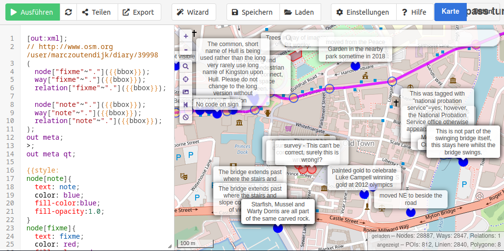
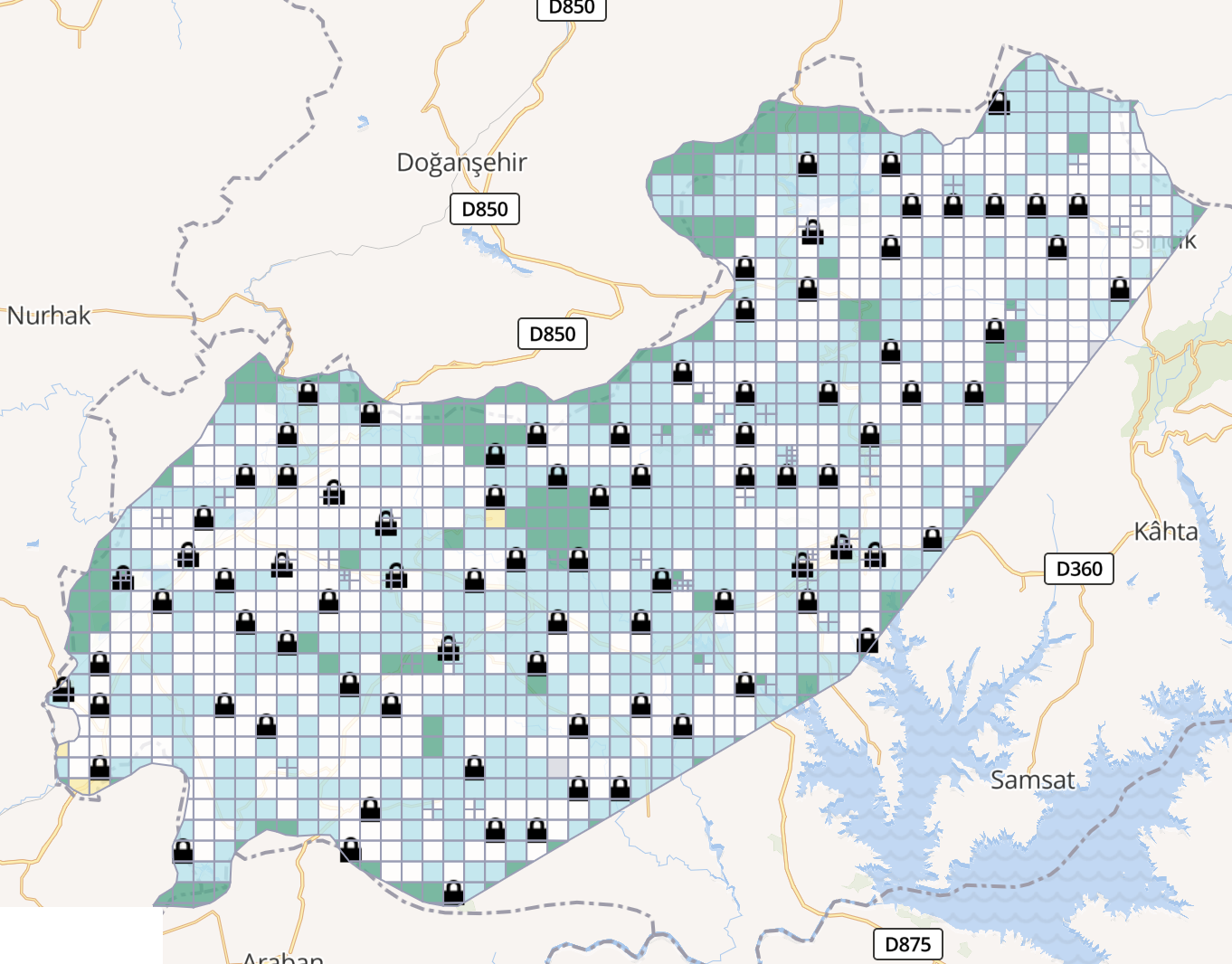
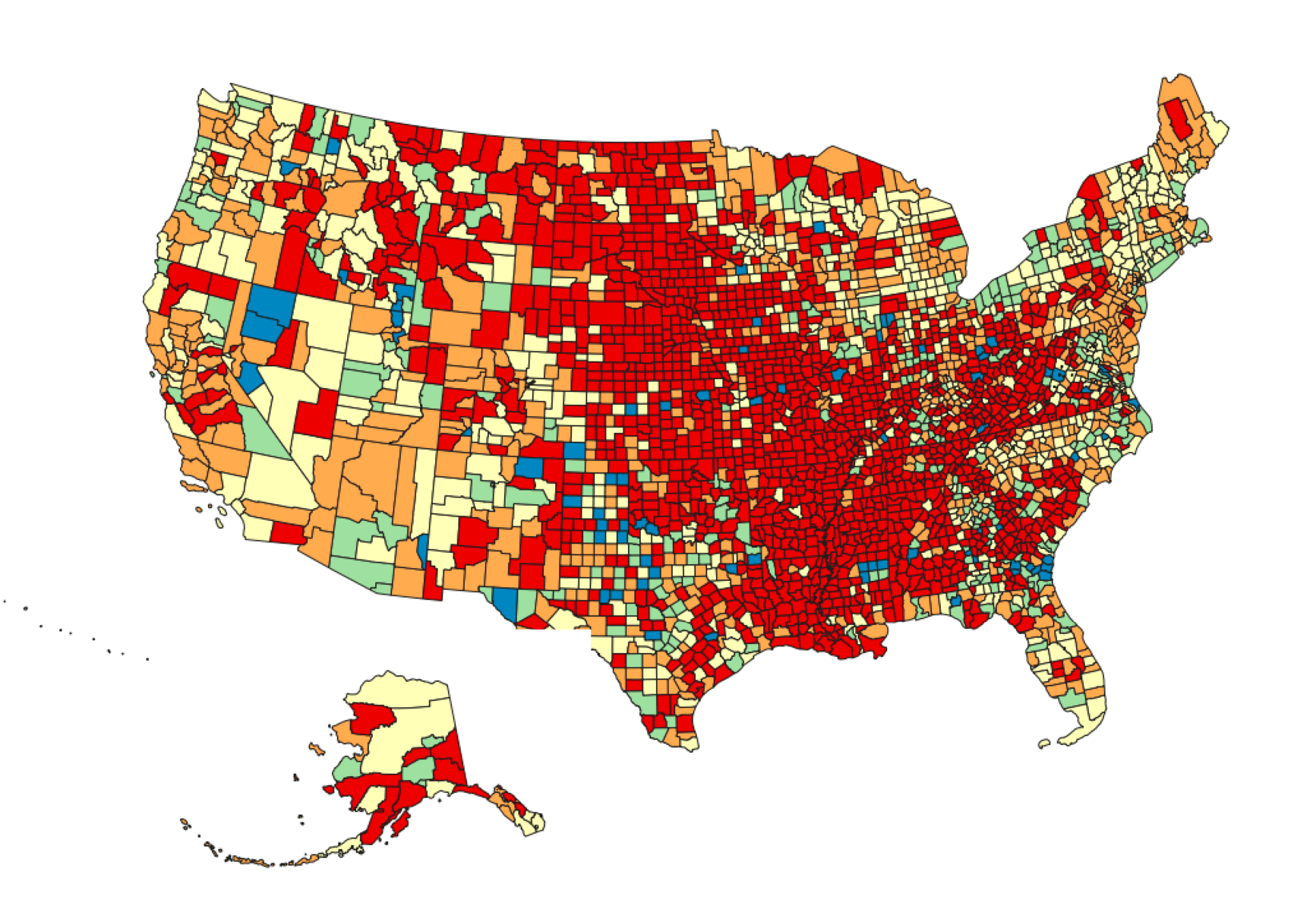
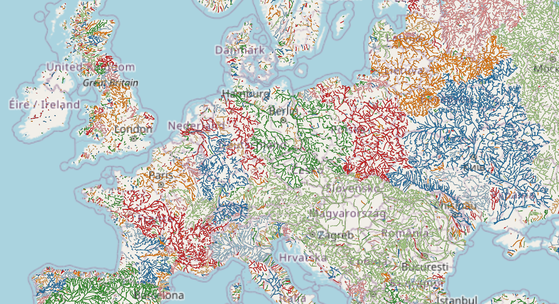
Colour-coded buildings by age [1] | © uMap and SK53 | map data © OpenStreetMap contributors

Breaking news

  • The first meeting of the new OSMF Board after the 16th Annual General Meeting was held on Tuesday 20 December. New officers have been selected as Secretary, Personnel Committee Chair, Open Source Initiative OSM Delegate and the Trademark licensing subcommittee representative.
    • New officers roles are :
      • Chairperson: Guillaume Rischard
      • Secretary: Mikel Maron
      • Treasurer: Roland Olbricht
    • Non-officer roles are :
      • Sarah Hoffmann: Personnel Committee chair and Open Source Initiative OSM delegate
      • Mikel Maron: Finance Committee chair
      • Mateusz Konieczny: Trademark licensing subcommittee representative
      • Arnalie Vicario
      • Craig Allan
    • Officers’ contact emails.

Mapping

  • Fabio Lovato has built a map of fuel prices in Italy. Fabio explained how the map was made using data from Italy’s Ministry of Economic Development and uMap via a PHP script.
  • A request for comments has been made for healthcare=department, a tag for the departments of a hospital or a clinic.

Community

  • Who needs to be a heroic Google Maps Local Guide when you have weeklyOSM? OpenStreetMap Pontarlier, if you are reading this, thanks.
  • OpenStreetMap Perú was one of the organisers of the ‘Grassroots disaster risk management and OpenStreetMap LATAM 2022’, which was held from 24 to 27 November. Along with the usual conference activities there was a guided tour of the national disaster centre and the Caral archaeology site. meerkat88 , Caminando Cusco , and mapeadora have written diary entries on their conference experiences.
  • Nigeria held its first State of the Map from 1 to 3 December. A number of participants have written of their experiences, including Teeman whose journey to the conference was eventful, johanespeter9 who wanted to be local so ate local, and vicksun who gave thanks to the many people responsible for the success of the event.
  • Rounding out this week’s rush of conference reports are those from Pista ng Mapa, which this year included the State of the Map Asia. There are so many that we can only list a small sample. frozenrabi blogged about how excited he was to travel outside Nepal for the first time, dichapabe highlighted some of the social activities they participated in, and Mia Kristine let us in on the confessions of a first time attendee.

Open Data

  • A summary what we have found about Overture Maps:
    • The OSM Foundation’s view.
    • A number of thoughts about Overture Maps on the OSM Community forum.
    • A comment in the Russian OSM Blog .
    • An analysis in Le Temps .
    • ArsTECHNICA thinks that the idea is to ‘break the Google Maps monopoly’. AviationAnalysis sees it in the same way.
    • VentureBeat thinks that a combination of OSM data with AI is the target direction.
  • TUMI and Trufi Association presented a webinar exploring how transport data digitised in OSM can be developed, consumed, and iterated for better cities and sustainable mobility.

Software

  • Junior Flores has written an image recognition plugin for JOSM. Josm Magic Wand is designed to mark out the geometries of areas of similar colour and to merge the results where needed. Junior gave a presentation on Josm Magic Wand at Mapping USA 2022.

Programming

  • [1] Following up on his colour-coded buildings by age, SK53 has extended his Overpass Turbo code to work with any object in OSM.

Did you know …

  • … that you can track the progress of road gritters as they go about their business in Scotland? Take the opportunity to watch Spray Charles, Snowwayko Drift, Buzz Iceclear, Nitty Gritty, Mary Queen of Salt, and others as they carry out their work.

Other “geo” things

  • Apple has published improved maps of Switzerland and the Benelux countries. Improvements include colour highlighting of business districts. Buildings, parks, airports and shopping malls are captured in a higher level of detail than before.
  • OpenCage outlined their plan to move from Twitter to Mastodon as their primary social media channel for announcements.
  • GPS signals are being jammed in some Russian cities following Ukraine’s successful use of drone attacks. Wired reported how the GPS issues were first spotted by the monitoring system GPSJam, which uses data from planes to track problems with the satellite navigation system.

Upcoming Events

Where What Online When Country
Düsseldorf Düsseldorfer OpenStreetMap-Treffen 2022-12-30 flag
Stuttgart Stuttgarter Stammtisch 2023-01-03 flag
City of Westminster Missing Maps London Mapathon 2023-01-03 flag
København OSMmapperCPH 2023-01-08 flag
OSMF Engineering Working Group meeting 2023-01-09
München Münchner OSM-Treffen 2023-01-10 flag

Note:
If you like to see your event here, please put it into the OSM calendar. Only data which is there, will appear in weeklyOSM.

This weeklyOSM was produced by PierZen, Strubbl, TheSwavu, TrickyFoxy, danilax86, derFred.
We welcome link suggestions for the next issue via this form and look forward to your contributions.


týdeník 649

$
0
0

Zatím není dostupné

20/12/2022-26/12/2022

lead picture

Overtaking distance measurement for cyclists [1] | © openbikesensor.org | map data © OpenStreetMap contributors

About us

  • The weeklyOSM team would like to express our sincere gratitude to the entire OpenStreetMap community and to all of weeklyOSM’s readers. Your dedication and hard work have made a significant impact on the world of map making and have contributed to the growth and success of OpenStreetMap. The weeklyOSM team wish you all the best for the new year and hope it will be filled with new opportunities and continued growth for the OpenStreetMap community. May you all have a happy and prosperous new year!

Mapping

  • Florian Lohoff has started a series on ‘Geometry Mapping Antipatterns’:
    • first example: ‘Keep left‘ – why your navigation device sometimes gives instructions on a straight road.
    • second example: ‘Landuse drag‘ – when landuse gets complicated.
  • InfosReseaux blogged a call for mapping hydropower infrastructure. It’s not only about dams and powerhouses, but also about waterways. The OSM tagging model has been continuously developing to describe this.
  • Over the past year, a group of four mappers has added the origin of the names of over 1000 streets in Moers to OSM. The results can be seen on the Open Etymology Map.

Mapping campaigns

  • OpenStreetMap Indonesia launched a GLAM (galleries, libraries, archives & museums) themed mapathon from 20 to 25 December 2022.
  • Legitimater enjoys mapping trees and by this making the map become greener. He invited mappers to join in and use the hashtag #OperationGreen on changesets.

Community

Maps

switch2OSM

  • Eugene Alvin Villar has created a small quiz with respect to OSM communities. Do you know where these three OSM URLs point to?
    1. openstreetmap.community (solution)
    2. community.openstreetmap.org (solution)
    3. openstreetmap.org/communities (solution)

Open Data

  • Topi Tyukanov has compiled the most liked tweets of the 30DayMapChallenge 2022 into one page.
  • Andrii Holovin wrote a two-part blog post (part1, part 2) on his thoughts about Overture and the future of OSM.

Software

Programming

  • Paul Norman let us know that the API database servers will be unavailable on Sunday 22 January 2023 between 10:00 and 15:00 UTC due to maintenance. Map editing (using iD, JOSM, etc), and replication updates will be paused during that period. Login to services that require osm.org authentication may be also unavailable.
  • Max Bo examined the proximity of the City of Sydney’s QMS billboards (we reported earlier) to Telstra public telephones using OSM data for an article they wrote.

Releases

  • The December update of Organic Maps has been released. As usual the maps have been updated and the routing and translations improved. Also KML tracks are handled better now.

Did you know …

  • mastodon near me? These are the Mastodon instances with a local connection that may or may not have room for newbies.

Upcoming Events

Where What Online When Country
Düsseldorf Düsseldorfer OpenStreetMap-Treffen 2022-12-30 flag
Stuttgart Stuttgarter Stammtisch 2023-01-03 flag
City of Westminster Missing Maps London Mapathon 2023-01-03 flag
Berlin OSM-Verkehrswende #43 (Online) 2023-01-03 flag
København OSMmapperCPH 2023-01-08 flag
OSMF Engineering Working Group meeting 2023-01-09
München Münchner OSM-Treffen 2023-01-10 flag
Berlin 175. Berlin-Brandenburg OpenStreetMap Stammtisch 2023-01-12 flag
Seattle World Railway Mapping Online Quarterly Meetup. 2023-01-14 flag
159. Treffen des OSM-Stammtisches Bonn 2023-01-17
London Geomob London 2023-01-18 flag
Karlsruhe Stammtisch Karlsruhe 2023-01-18 flag
Dar es Salaam State of the Map Tanzania 2023-01-19 – 2023-01-21 flag

Note:
If you like to see your event here, please put it into the OSM calendar. Only data which is there, will appear in weeklyOSM.

This weeklyOSM was produced by MatthiasMatthias, SK53, Strubbl, TheSwavu, derFred.
We welcome link suggestions for the next issue via this form and look forward to your contributions.

týdeník 650

$
0
0

Zatím není dostupné

27/12/2022-02/01/2023

lead picture

marczoutendijk’s Overpass query to locate fixme tags [1] | © marczoutendijk | map data © OpenStreetMap contributors

Mapping

  • TrickyFoxy wrote, on telegra.ph, an article on ‘Why you should try Every Door’.
  • Requests have been made for comments on the following proposals:
    • emergency=fire_water_inlet for mapping an inlet to a building’s firefighting system.
    • place=sea to deprecate the use of a closed way or multipolygon to map a marginal sea or named portion of an ocean in favour of using a place=sea node.
    • shop=yarn to tag a business primarily selling yarn and supplies for knitting or crochet.

Mapping campaigns

  • [1] The new quarterly project for the UK has started. The UK community will be working on fixme and Notes over the next three months.

Community

  • feyeandal highlighted the contributions of university clubs with local chapters of YouthMappers in the OSM-Philippines community in 2022 and shared a short reflection about the impact of YouthMappers in a local context.
  • A new ‘Communities’ tab has been added to the main page of openstreetmap.org. You can see it in the upper right corner. The tab links to a single location that lists formal Local Chapters, as well as the other OSM communities. Read more about its background on the OpenStreetMap blog.
  • On the request of Andrii Holovin, the OSM Ops Team created a short URL for community.openstreetmap.org. The quiz we reported on last week could now be extended with c.osm.org.
  • OSM Belgium announced their mapper of the month: lusdavo.

OpenStreetMap Foundation

Events

  • jomo participated in the Fireshonks conference in December where he talked about how to improve skills and knowledge in the OSM ecosystem. He showed various editors, validators, parsers and other tools for both general and more specific purposes and also shared some tips and tricks that he has learned during several years of OSM mapping.

Maps

  • Raster map provider Tracestrack announced that they have started to render country-specific motorway shields. Shield reference text is selected randomly from ref, nat_ref and int_ref. The style can be explored via Map Explorer.

Open Data

  • Microsoft released new data on missing roads based on fresh (2020–2022) aerial imagery.
  • mmd has wiki’ed blog posts from various people in the OSM community in a very long thread on Overture and asks others to make additions.

Software

  • Victor Shcherb (CEO of OsmAnd) published the OsmAnd 2023 ‘New Year Resolutions’.
  • IzzyOnDroid tooted that the Every Door editor has made it to the Android app store F-Droid.
  • Overpass Ultra is a fork of the popular tool overpass turbo. The developers note that ‘because it uses MapLibre GL JS instead of Leaflet, it can be used to visualise significantly larger Overpass API results than overpass turbo’.
  • In his diary, Jiri Vlasak (qeef) summarised what happened in the development of Divide and map. Now. over the last year, and outlined the plans for 2023. Divide and map. Now. helps mappers by dividing a big area into smaller squares that people can map together.

Programming

  • Xavier Olive released Cartes, which is a ‘Python library providing facilities to produce meaningful maps’. Xavier provides documentation and an Anaconda Python package.
  • Gero Gerke started a series of blog posts about implementing an OpenStreetMap data vector renderer using WebGL.
  • RGCosm is a new minimal ‘Reverse Geocode for OpenStreetMap’. According to the developer’s Hacker News announcement: ‘ChatGPT wrote most of the code for me. Created it in about three hours, where the time is combined with creating the DB, and testing it with the rest of the code for a different project’ (sqlite3 + python + pyosmium).
  • richlv linked to his script that brings back Mapillary’s vanished feature to create a GPX file from image sequences.
  • A small update to the openstreetmap.org website now makes it possible to verify your OSM user account on Mastodon. A toot by Pieter Vander Vennet explains how to do this.

Did you know …

  • … this map of Russian river basins ?
  • … the monthly Geotrivia game hosted by OpenCage on Mastodon? The next game is scheduled for 27 January 2023.

Other “geo” things

  • The Bomann Museum in Celle (Germany) is hosting the exhibition ‘Die wahre Vermessung der Welt’ (The True Measurement of the World) about the mapping of the Kingdom of Hanover by Carl Friedrich Gauss. The exhibition runs until 30 May 2023.
  • Google is working on an Apache-2.0 licensed project named forma, which is a ‘parallelised experimental Rust vector-graphics renderer’. One of their examples is to render a big SVG of Paris nearly instantly. Bert Temme shared videos of the renderer’s speed by comparing the Chrome Browser with forma.

Upcoming Events

Where What Online When Country
København OSMmapperCPH 2023-01-08 flag
OSMF Engineering Working Group meeting 2023-01-09
Stuttgart Stuttgarter Stammtisch 2023-01-10 flag
München Münchner OSM-Treffen 2023-01-10 flag
Salt Lake City OSM Utah Monthly Map Night 2023-01-12 flag
Berlin 175. Berlin-Brandenburg OpenStreetMap Stammtisch 2023-01-12 flag
Seattle World Railway Mapping Online Quarterly Meetup. 2023-01-14 flag
159. Treffen des OSM-Stammtisches Bonn 2023-01-17
London Geomob London 2023-01-18 flag
Karlsruhe Stammtisch Karlsruhe 2023-01-18 flag
Dar es Salaam State of the Map Tanzania 2023-01-19 – 2023-01-21 flag
Budapest Hiking by the pipeline between Normafa-Stop Shop-Aranyvölgy 2023-01-21 flag
Toulouse Réunion du groupe local de Toulouse 2023-01-21 flag
Downtime 2023-01-22
Bremen Bremer Mappertreffen (Online) 2023-01-23 flag
Düsseldorf Düsseldorfer OpenStreetMap-Treffen 2023-01-25 flag

Note:
If you like to see your event here, please put it into the OSM calendar. Only data which is there, will appear in weeklyOSM.

This weeklyOSM was produced by MatthiasMatthias, PierZen, SK53, Strubbl, TheSwavu, derFred, tordans.
We welcome link suggestions for the next issue via this form and look forward to your contributions.

týdeník 651

$
0
0

Zatím není dostupné

03/01/2023-09/01/2023

lead picture

Valhalla – open-source routing engine available on osm.org [1] | map data © OpenStreetMap contributors

Breaking news

  • Paul Norman announced the release of version 5.7.0 of the OpenStreetMap Carto Stylesheet, the default map stylesheet for the OSM website, on the mailing list and in his blog. All changes can be found there.The most obvious change, as the OSM Ops team tweeted, is the representation of unpaved roads. Unpaved roads will be rendered with a subtle stipple effect to show them as being not paved. The OSM Ops Team says: ‘Unpaved roads with a suitable tag will be styled differently. Change background: https://github.com/gravitystorm/openstreetmap-carto/pull/3399‘.The Ops team goes on to say ‘this unfortunately leaves a dilemma, many regions in OpenStreetMap unpaved is the presumed default in the absence of a surface= tag. But! We can fix this, let us map if roads are surface=paved or surface=unpaved (or more specific types)’.The OSM Ops Team then turned to three organisations with a friendly appeal for help: ‘Germany already has 46% of roads surfaces mapped. Zimbabwe it is only 14%. So let us get mapping road surfaces! How about it? @hotosm @osmafrica @youthmappers’.

    Ways with no surface tag can easily be found using overpass turbo.

Mapping

  • -karlos- blogged about ‘area’ as a new object type in the OSM data model, why in his opinion it is a good improvement, and where he expects difficulties to arise.
  • Bob Cameron (bob3bob3) described how he takes photos and audio commentaries on the road and processes them automatically to use them at home for improving OSM.
  • Bob Cameron (bob3bob3) explained how he tags amenity=parking and highway=rest_area, having generally adopted a formal vs informal categorisation.
  • Kai Johnson explained how he distinguishes between highway=service and highway=track.
  • Lars Schwarz is experimenting with using the 3D Model generated by Polycam to collect infrastructure data for OSM.
  • Quite Frankly is embarking on a project to ‘document and update cycle lanes on every street in Melbourne and eventually Victoria in as much detail as possible’ using tagging schemes that he says were developed specifically for the detailed documentation of cycling infrastructure . Other tools being used: StreetComplete, iD, JOSM, Vespucci and Hauke Stieler’s Simple Task Manager.
  • steveman1123 blogged about his armchair mapping activities and what keeps him motivated while doing so.
  • Requests have been made for comments on the following proposals:
    • emergency=air_rescue_service to tag the buildings and base areas of those groups that use aircraft, either fixed-wing or helicopters, for either aerial Search and Rescue, or Aeromedical Evacuation purposes.
    • emergency=water_rescue for mapping the buildings and base areas, both on and off water, of those groups that are dedicated to the rescue of vessels and/or sailors in distress.
  • Voting is open on the proposal to announce proposals on the OSM Community forum as well as the tagging mailing list, until Saturday 21 January.
  • Voting on the following proposals has closed:
    • historic=*, to approve a number of values of the historic tag, was not successful with 11 votes for, 15 votes against and 1 abstention.
    • fountain:design=*, for specifying what type of fountain an amenity=fountain is, was not successful with 13 votes for, 8 votes against and 1 abstention.

Mapping campaigns

  • User kubahahaha has created several MapRoulette quests for populating OSM with Polish government data, published under the CC0 licence. Multiple TagFix and Cooperative challenges are available. Discussion on tagging is ongoing in the Polish OSM Community forum.

Community

  • Ciarán Staunton (DeBigC) is full of praise for Anne-Karoline Distel (b-unicycling), who has contributed a whopping 5,000,000 changes to OpenStreetMap. Also read her blog post about this jubilee.
  • Courtney Williamson asked for feedback on the proposed changes to the OSM data model (we reported earlier).
  • Ronald Ontiveros, from Mexico, is the UN Mapper of the Month for January.

Events

  • The next OSM hack weekend in Karlsruhe, Germany, will be held / on 25 and 26 February. Surely you have some unfinished OSM projects or some good ideas for new ones. Bring them with you to Karlsruhe. You will find people to discuss the details with you, or to build something with.

Education

  • The UN Maps crowdsourcing team is offering a free online training workshop, in French, about ‘OpenStreetMap and Humanitarian Mapping’, open to anyone who is new to OpenStreetMap. Registration and is open until Tuesday 31 January 00:00 UTC. The two hour workshops will be held every Thursday starting 2 February for nine weeks, a total of 18 hours.
  • AddisMapTransit and OpenStreetMap Ethiopia held a series of training workshops for OpenStreetMappers in Addis Ababa, Ethiopia.

OSM research

  • Simon Poole noted that fewer people signed up for OpenStreetMap last year and presented some interesting figures and thoughts. Paul Norman, from the Operations Working Group, contributed detailed numbers on where new users come from.

Maps

  • [1] Valhalla, a global routing service hosted by FOSSGIS e.V., is now part of the routing selection (with foot, bike and car profile) on the OSM website. For more information there is a wiki page, Simon Poole’s comment on the OSM Community forum, and the GitHub repository.
  • Romain de Bossoreille has generated a map Space Industry around the World using data from The Space Devs, Wikidata and OpenStreetMap.

Open Data

  • The value of the new road detections datasets provided by Microsoft (as we reported earlier) was discussed on the OSM Community forum.

Software

  • User NorthCrab announced the release of ‘osm-revert’, a tool to perform changeset reversion with a simple web interface requiring merely an OSM login, the id of the changeset to be reverted, and the comment for the new changeset. Tom Hughes, an OSM website maintainer, expressed doubts as to whether a ‘point-and-click’ reverter is a good idea.

Programming

  • Inspired by Overpass Ultra (we reported earlier) rtnf attempted to install MapLibre GL Native on their Android platform. They documented some of the gotchas that need to be circumvented in order to get a working installation.
  • SK53 described a method to find steep paths, which may need review on OSM. In a follow-up he enhanced his process to calculate the slope angles likely to be encountered by walkers.
  • TreeTracks has published an article on how Overpass can be used to perform data analytics with OpenStreetMap. As an example, the road infrastructure in cities is compared to that found in the Australian bush.

Did you know …

  • … Lejun’s list of geographers represented on Mastodon? On GitHub you can find a collection with many other disciplines and communities ranging from African studies to a community server dedicated to circuses.
  • … there is a tool that generates RSS feed links for the various OpenStreetMap Quality Assurance sites for a given area?

OSM in the media

  • The Swiss magazine PCtipp published ‘six tips for beginners’ in OpenStreetMap on its blog.
  • Alex Seidel published an article about the Neukölln street map (which we have reported before) in the Kartographische Nachrichten, a newsletter for professional cartographers.
  • Heise.de, a German IT news site, asked three questions of TomTom’s Michael Harrell in connection with Overture Maps and OpenStreetMap in a commercial guise.

Other “geo” things

  • OpenCage has published a new ‘geoweirdness’ – this time on Croatia.
  • The Bexhill OpenStreetMap website has added a page describing the origins of street names in the Bexhill area. The information was collected by local historians over several decades, but will be very interesting to enthusiasts of the name:etymology tag in understanding how streets got their names.
  • Overture Maps this week:
    • Steven Feldman interviewed Marc Prioleau from Meta on the GeoMob Podcast.
    • James Killick published his ideas on Overture in a blog post.
    • Dorothea has created a summary of what has been published about Overture.
  • Meduza, a Latvian blog, reported, in an article referring to TASS, about a ‘bill to ban maps that “call Russia’s territorial integrity into question”‘.
  • HERE has introduced ‘Unimap’, mapping technology designed to create maps automatically.

Upcoming Events

Where What Online When Country
Seattle World Railway Mapping Online Quarterly Meetup. 2023-01-14 flag
臺北市 OpenStreetMap 街景踏查團工作坊 #6 2023-01-14 flag
Budapest OSM Weaving: Remote help, Aranyvölgy pipeline preparation (online) 2023-01-16 flag
Grenoble Rencontre du groupe local de Grenoble 2023-01-16 flag
臺北市 OpenStreetMap x Wikidata 月聚會 #48 2023-01-16 flag
Lyon Rencontre mensuelle Lyon 2023-01-17 flag
San Jose South Bay Map Night 2023-01-18 flag
159. Treffen des OSM-Stammtisches Bonn 2023-01-17
London Geomob London 2023-01-18 flag
Karlsruhe Stammtisch Karlsruhe 2023-01-18 flag
Dar es Salaam State of the Map Tanzania 2023-01-19 – 2023-01-21 flag
Budapest Hiking by the pipeline between Normafa-Stop Shop-Aranyvölgy 2023-01-21 flag
Toulouse Réunion du groupe local de Toulouse 2023-01-21 flag
Downtime 2023-01-22
Bremen Bremer Mappertreffen (Online) 2023-01-23 flag
OSMF Engineering Working Group meeting 2023-01-24
Düsseldorf Düsseldorfer OpenStreetMap-Treffen 2023-01-25 flag
[Online] OpenStreetMap Foundation board of Directors – public videomeeting 2023-01-26
IJmuiden OSM Nederland bijeenkomst (online) 2023-01-28 flag
南区 京都!街歩き!マッピングパーティ:第35回 六孫王神社 2023-01-29 flag
Windsor OSM Windsor-Essex Monthly Meetup 2023-01-31 flag
San Jose South Bay Map Night 2023-02-01 flag

Note:
If you like to see your event here, please put it into the OSM calendar. Only data which is there, will appear in weeklyOSM.

This weeklyOSM was produced by MatthiasMatthias, PierZen, SK53, Strubbl, TheSwavu, YoViajo, conradoos, derFred.
We welcome link suggestions for the next issue via this form and look forward to your contributions.

týdeník 652

$
0
0

Zatím není dostupné

10/01/2023-16/01/2023

lead picture

Osmose QA introduces a new check [1] | © Public Domain

Breaking news

  • The next public OSMF Board meeting will be held in the online boardroom on Thursday 26 January at 13:30 UTC.
    The preliminary agenda is on the Board/Minutes/2023-01 wiki page and this is also where the draft minutes will be added.The topics to be covered are:
    • Treasurer’s report
    • Provisional 2023 budget
    • Strategic plan – formal structure report
    • Advisory Board – monthly update
    • Monthly presentation – YouthMappers
    • Guest comments or questions.

    Find out on the Monthly Board Meetings wiki page how to have future board meetings automatically added to your calendar.

About us

  • Do you read our blog in English?
    Do you want to read the new issue two days earlier?
    Do you want to help prepare weeklyOSM?
    Are you a native English speaker?
    Then we are looking for you!
    Write us a short email to info at weeklyosm dot eu and we will let you know how you can help.
  • From this issue we are publishing our weeklyOSM articles under the CC0 licence instead of CC-BY-SA. You can link, cite, reuse or rephrase our articles without restrictions. Nevertheless we are of course happy if you still attribute us.

Mapping

  • One culture’s profanity may be another’s street name. Meta’s #ProfanityCleanup edits triggered a discussion on Talk-GB about this topic.
  • Andy Townsend (SomeoneElse) documented how he followed a path that existed only on a map and concluded that it doesn’t belong in OSM.
  • Mateusz Konieczny is seeking the community’s view on the difference between surface=fine_gravel and surface=compacted.
  • Voting is underway on the proposal to extend the usage of utility=* to apply consistently to service/industrial buildings and cabinets, until Thursday 26 January.

Community

  • In the Geomob Podcast #164 Ed Freyfogle chatted with Simon Poole, OSM mapper since 2010, former chair of the OSMF, and maintainer of Vespucci, about his perspective on OpenStreetMap.
  • The OpenStreetMap Ops Team gave an update on the status of the migration of the old forum content to the new OSM Community forum.

Local chapter news

  • The OpenStreetMap Polska Association is proud to announce the signing of an agreement with CloudFerro, the operator of the Creodias platform to enable, but not limited to, further development of the www.openaedmap.org project.

Events

  • @dukera, in a video, explained how Overpass can be used in geospatial intelligence.
  • Edward Betts is going to talk at the upcoming FOSDEM about linking OpenStreetMap and Wikidata.

OSM research

  • A paper from HeiGIT and GIScience at Heidelberg University, on improving the accuracy of OSM missing building detection in sub-Saharan Africa, was featured on the May 2022 cover of Transactions in GIS. The team proposed a novel few-shot transfer learning method (FSTL) to improve humanitarian organisations’ mapping workflows in the Global South. Further details on the approach, and its current limitations, is available on the HeiGIT site.

Licences

  • Pieter Vander Vennet investigated, using Overpass, what licences MapComplete users are applying to their uploaded pictures. The vast majority are uploaded with the default licence, being CC0/public domain. Power users, though, often change the licence to CC-BY or CC-BY-SA. As a by-product of his investigation, a ranking of MapComplete’s most active users has been compiled, led by ‘legendary mapper’ Awo.

Software

  • Anne-Karoline Distel spotted that Field Papers was not working (see also a Reddit thread). Ciarán (DeBigC) reported it on GitHub and, fortunately, Alan Maconchie restarted the server. However, as with other Stamen services, they are looking for others to take on support.
  • James Milner found that ChatGPT is pretty good at generating GeoJSON.
  • GeoDesk reported a new feature: stats queries. The thread includes various examples of typical queries, from the opening hours of pubs in Scotland, to the length of rivers in Colorado.

Programming

  • MTRNord tooted that they have created a script to quickly build transit maps using the Cartes tool, after it was reported on weeklyOSM.

Releases

  • QA tool Osmose has introduced a new check for buildings on agricultural land that appear to be too large.

Did you know …

  • … there are special phrases that cause Nominatim to search for a specific key=value pair?
  • … if you mix up latitude and longitude, Alvin Bryan has some tips to remember them correctly?

OSM in the media

  • Carey Davies, writing in The Great Outdoors magazine, provided in-depth analysis of recent mountain rescue incidents in the English Lake District, which were occasioned by the use of outdoor hiking apps based on OpenStreetMap data. Earlier, The Guardian and online magazine Grough had also covered this topic. It is these reports that led to SK53’s path analysis, which we reported earlier.
  • Alex Roddie, quoted in The Great Outdoors article above, published his own detailed analysis of the use of OpenStreetMap by a range of outdoor hiking applications. He received a lot of feedback from experienced UK-based mountain guides on both Twitter and Mastodon.
  • Netzpolitik recommended installing StreetComplete and other FOSS tools to rid yourself of GAFAM.

Other “geo” things

  • Google Maps has introduced a visual positioning system ‘to provide location and navigation services for users of its AR “Live View” feature’.
  • Giorgia Tolfo blogged on how the Living with Machines project is digitising 19th century Ordnance Survey maps from the British Library. The work is complementary to the well-known historical maps hosted by the National Library of Scotland, as the focus is on maps not already available digitally. Living with Machines is the flagship Digital Humanities project of the Turing Institute, the UK national AI research institute.
  • The American Geographical Society published its ‘Map of the week’ with the title ‘What does the land under Antarctica’s ice sheet look like?’.
  • Christoph Hormann wrote about the open licensing of map designs.
  • Abhishek Nagaraj and Scott Stern have written an essay on the distinctive economic properties of maps and the role that geographic information plays in economic geography.
  • Astronomers also create maps. See the universe from above!

Upcoming Events

Where What Online When Country
Dar es Salaam State of the Map Tanzania 2023-01-19 – 2023-01-21 flag
Budapest Hiking by the pipeline between Normafa-Stop Shop-Aranyvölgy 2023-01-21 flag
Toulouse Réunion du groupe local de Toulouse 2023-01-21 flag
Downtime 2023-01-22
Bremen Bremer Mappertreffen (Online) 2023-01-23 flag
OSMF Engineering Working Group meeting 2023-01-24
Düsseldorf Düsseldorfer OpenStreetMap-Treffen 2023-01-25 flag
[Online] OpenStreetMap Foundation board of Directors – public videomeeting 2023-01-26
IJmuiden OSM Nederland bijeenkomst (online) 2023-01-28 flag
南区 京都!街歩き!マッピングパーティ:第35回 六孫王神社 2023-01-29 flag
Windsor OSM Windsor-Essex Monthly Meetup 2023-01-31 flag
San Jose South Bay Map Night 2023-02-01 flag
Hannover OSM-Stammtisch Hannover 2023-02-06 flag
MapRoulette Monthly Community Meeting 2023-02-07
Stuttgart Stuttgarter Stammtisch 2023-02-07 flag
City of Westminster Missing Maps London Mapathon 2023-02-07 flag
Zürich OSM-Stammtisch 2023-02-08 flag
München Münchner OSM-Treffen 2023-02-08 flag
Salt Lake City OSM Utah Monthly Map Night 2023-02-09 flag
Neufchâteau OpenStreetMap – Réunion à Neufchâteau 2023-02-09 flag

Note:
If you like to see your event here, please put it into the OSM calendar. Only data which is there, will appear in weeklyOSM.

This weeklyOSM was produced by MatthiasMatthias, Nordpfeil, PierZen, SK53, Strubbl, TheSwavu, YoViajo, derFred.
We welcome link suggestions for the next issue via this form and look forward to your contributions.

týdeník 653

$
0
0

Zatím není dostupné

17/01/2023-23/01/2023

lead picture

osmimgur : See tagged imgur images on OSM [1] | map data © OpenStreetMap contributors

Mapping

  • User bradrh consulted the US Forest Service Motor Use Maps to update motor vehicle access restrictions on forest roads and trails in several national forests.
  • Bryce Cogswell (bryceco) listed every OpenStreetMapper that has managed to map for more than a thousand days without a break.
  • Lejun described how to merge data from different sources into OpenStreetMap. He explained the different tools and methods, including the JOSM plugin UtilsPlugin2.
  • Christoph Hormann wrote a blog post describing the problems with the name key and promised to try to propose a possible solution in his next post.
  • Tomas_J has provided
    pictures and suggested tagging for a few Slovak-specific features.
  • Valerie Norton (valhikes) has summarised her mapping activity around Gunnison, Colorado between February and September 2022. Details of each hike, with lots of photos, are posted on her blog.
  • Voting on the suggestion to announce proposals on the OSM Community forum, as well as the tagging mailing list, has closed. It was approved with 48 votes for, 5 votes against and 0 abstentions.

Community

  • OpenStreetMap recently hit a milestone with more than 10 million user accounts. The milestone was discussed on r/openstreetmap. It should be noted that only about 1.9 million of these accounts have been used to make a map edit.
  • Daniel Capilla (dcapillae) has created a tutorial on how to make a metrominuto (a schematic map of a municipality or city that represents the distances between its main points and the average time it takes to walk between them) of your area of interest.
  • Mevesscarto gave us an update on their progress to armchair map the French department Côtes d’Armor.
  • watmildon explained the JOSM and MapWithAI workflow that they are using to add missing street addresses to OSM.

OpenStreetMap Foundation

  • Get to know the new OSMF Board. In December 2022, four new members were elected to the OpenStreetMap Foundation Board, complementing the three members already serving. The new members, Arnalie Vicario, Craig Allan, Mateusz Konieczny, and Sarah Hoffmann, have joined Guillaume Rischard, Mikel Maron, and Roland Olbricht.

Local chapter news

  • Nominations for the OpenStreetMap US 2023 Board Elections are now open. The OSM US blog has more details if you are interested.

Education

  • UN Mappers has launched the UN Maps Learning Hub, a self-learning platform accessible to anyone interested in the OpenStreetMap project. Courses will be available in several languages and will cover aspects of topographic and humanitarian mapping. The OSM Basics course is already available.

OSM research

  • With the release of the OSHDB (OpenStreetMap History Database) Version 1 for spatio-temporal analysis, the HeiGIT team at Heidelberg University has reached an important milestone. The data is open to everyone, whether they belong to journalism, science or humanitarian organisations. The ohsome dashboard allows you to analyse OSM temporal data for any region. A significant enhancement is the new OSHDB filters that allow practitioners to filter entities by the shape of the geometry (one measure of quality often discussed by the OSM community).
  • GeoObserver has published the third part of its ‘Meierloch’ trilogy on the distribution of surnames and their visualisation on a map.

switch2OSM

  • Roberto Brazzelli described how the municipality of Limone (Piemonte, Italy) provides a map of amenities using uMap. Data is maintained in OSM by council staff, but updates are quality controlled via QGIS with data cached in Google Sheets from Overpass queries.

Software

  • Kshitij Raj Sharma has created ‘OpenStreetMap Stats Generator’, which uses osmium to analyse the change files from OSM and generate statistics in different file formats such as csv, json, and jpg. Results are also being tweeted. A second bot follows the recent trends on OSM and retweets the findings with hashtags #osm, #openstreetmap and #hotosm every three hours.
  • rtnf asked why the OpenStreetMap Stats Generator needs an OpenStreetMap login and proposed a lightweight version without the need for credentials.

Programming

  • [1] rtnf, inspired by posts on imagery collected by MapComplete (we reported earlier), has created a web app that randomly samples MapComplete images. In his blog, he explained how to visualise tagged imgur images on OSM.
  • Jake Coppinger reported on his efforts writing a vector tile server for osm2streets to provide lane-accurate street maps with OpenStreetMap. Jake also revealed that his Safe Cycling Map now works for the entire world.
  • Tobin Bradley recorded a screencast video that captures how protomaps is used to create a PMTiles file, a single file vector tiles format, and integrate it into a MapLibre demo map. This setup allows you to create vector tile maps with static infrastructure.
  • starsep explained how Bing StreetSide imagery can be used for mapping with JOSM.

Did you know …

  • … about the shop suffix for repair? You can use this to specify services available for computers, bicycles, shoes and more, as tooted by OSM Tourism.
  • … Thomas Gratier’s comprehensive listing of map-related things?
  • … the OSM Welcome tool, hosted by OSM-Belgium? This app helps identify new contributors to OSM in a given area, how many edits they’ve made, and their preferred editor. It also keeps track of which users have been sent a welcome message via the site.
  • … the comparative overview of possibly every OSM-related Android app?

Other “geo” things

  • The Equal Earth physical map of the world is now available in German, thanks to the work of Simon Scherrer.
  • Devin Lea has started a new weekly social media hashtag #MapPromptMonday with a different theme each week. Last week the theme was using colour-blind friendly symbology. Upcoming themes have been listed.

Upcoming Events

Where What Online When Country
IJmuiden OSM Nederland bijeenkomst (online) 2023-01-28 flag
南区 京都!街歩き!マッピングパーティ:第35回 六孫王神社 2023-01-29 flag
Windsor OSM Windsor-Essex Monthly Meetup 2023-01-31 flag
San Jose South Bay Map Night 2023-02-01 flag
Hannover OSM-Stammtisch Hannover 2023-02-06 flag
MapRoulette Monthly Community Meeting 2023-02-07
OSMF Engineering Working Group meeting 2023-02-07
Strasbourg Mapathon CartONG 2023-02-07 flag
City of Westminster Missing Maps London Mapathon 2023-02-07 flag
Stuttgart Stuttgarter Stammtisch 2023-02-07 flag
Zürich OSM-Stammtisch 2023-02-08 flag
Salt Lake City OSM Utah Monthly Map Night 2023-02-09 flag
London London social pub meet-up 2023-02-08 flag
München Münchner OSM-Treffen 2023-02-08 flag
Neufchâteau OpenStreetMap – Réunion à Neufchâteau 2023-02-09 flag
左京区 京都!街歩き!マッピングパーティ:第36回 金地院 2023-02-12 flag
København OSMmapperCPH 2023-02-12 flag
San Jose South Bay Map Night 2023-02-15 flag
Karlsruhe Stammtisch Karlsruhe 2023-02-15 flag
Olomouc únorový olomoucký mapathon 2023-02-16 flag

Note:
If you like to see your event here, please put it into the OSM calendar. Only data which is there, will appear in weeklyOSM.

This weeklyOSM was produced by ChristopherGS, Kasey2, MatthiasMatthias, Nordpfeil, PierZen, SK53, SeverinGeo, Strubbl, TheSwavu, barefootstache, derFred.
We welcome link suggestions for the next issue via this form and look forward to your contributions.

týdeník 654

$
0
0

Zatím není dostupné

24/01/2023-30/01/2023

lead picture

Andy Townsend is creating OSM maps for Garmin devices [1] | © Collage: Visual Studio Code screenshot of code by SomeoneElse and Garmin device by Virgilinojuca, CC BY-SA 4.0, via Wikimedia Commons

Mapping

  • As part of a series on how to generalise OSM data, Jochen Topf shared his insights about the generalisation of river networks.
  • In Cochabamba, Bolivia, the Trufi Association is encouraging users of their app to contribute informal transport routes using a simplified mapping feature.
  • Bobropiton has made three videos(1, 2, 3) about mapping bus routes and finding mislabelled routes.
  • HOT’s Open Mapping Hub – Asia Pacific has compiled a list of the most common data quality errors in OpenStreetMap by country and found some trends.
  • Christoph Hormann outlined a method of choosing what to render for compound names based on the default_language tag.
  • Valerie Norton (valhikes) reported about her mapping activities based on field trips from February to September 2022 in Calico. See also her other ‘Moments in Dirt and Ink’, for example about Fort Narraguinnep or the Dangerous Park.
  • Voting for the proposal to consistently extend the usage of utility=* to service and industrial landuses, buildings and cabinets has closed. The proposal was approved with 19 votes for, 4 votes against and 1 abstention.

Community

  • OpenCage published an interview with the OpenStreetMap Somalia Team on their blog.
  • Grant Slater shared his insights about the development and benefits of OSM, making reference to volunteers mapping South Africa’s power grid, among other aspects.

Imports

  • watmildon showed how the US National Address Database can assist in cleaning up TIGER tagging.

OpenStreetMap Foundation

  • Board members of the OpenStreetMap Foundation shared their personal visions for 2023 and promised in the comments that a collective vision will follow soon.

Maps

  • [1] Andy Townsend wrote that his Garmin maps are coming along nicely. You can download pre-made files for Great Britain or roll your own.
  • dcz had a dream of the perfect map for their cycling trip. Using TileMill and OSM data the dream became reality but the cycling trip didn’t.

Open Data

  • Adrion explained how to download, convert and import the National Heritage List for England into Vespucci or Orux Maps to use for mapping.
  • The Câmara Municipal da Horta, a municipality on Faial Island in the Azores, Portugal, is notifying of traffic direction changes using OpenStreetMap, including a credit to contributors.
  • Kai Johnson blogged on how he and watmildon analysed changes in GNIS data to find potential additions and corrections for OpenStreetMap in the US.

Software

  • Anthon Khorev’s ‘osm-note-viewer’ can now be used with other OpenStreetMap website-based projects. He explained more in his blog.
  • Pieter Vander Vennet has compiled some statistics about Open Reviews. Besides the official demonstration application, Mangrove, MapComplete’s implementation is the most popular.
  • Planet Lite, the copyright-free map of the entire world from MapTiler, has been upgraded with enhanced features. Some issue fixes in the lite version of MapTiler Planet complete the update.

Programming

  • Hans Thompson shared an R script to query elements from OSM and show them on a browser map using the Leaflet JavaScript tool. He used farmer market POI’s (amenity=marketplace) in his example.
  • Hungerburg explained
    how he used jq (a Linux command-line JSON manipulation utility) to parse and get an overview of a very large GeoJSON data file (in this case, a government open dataset of roads in Tirol).
  • Do you ever get confused by Overpass QL’s syntax? Now, you can highlight syntax elements in some editors: Visual Studio Code and other vscodium compatible editors, and KDE’s Kate.
  • Inspired by a video (we reported earlier), rtnf decided to make his own self-hosted vector tiles.

Releases

  • osm2pgsql 1.8.0 has been released. Thanks to PostgreSQL 15 osm2pgsql is even faster than before.
  • OrganicMaps has released a new version with improvements to KML importing, and elevation handling for hiking and cycling.

Did you know …

  • … Lorenz Matzat’s 2017 article ‘How OpenStreetMap can be used for journalism? The article is still relevant today and deserves more coverage.
  • … ivanbranco has a list of his favourite OSM tools? He has recently updated the list.

Other “geo” things

  • OpenCage has published the question and the results for January’s Geotrivia on their website. Would you have managed a chain of 10 countries like Ciarán Ferrie and rubpec? On Friday 24 February Ed will set the next task.
  • -karlos- has created two puzzles from an OpenStreetMap map using the tool Jigidi. You can find some other puzzles on Jigidi if you search for OpenStreetMap.
  • On 25 January it became apparent that the source code for various Yandex services had been leaked. The source code for Yandex.Map was included, in which users have found code to work with OpenStreetMap data (but with a note about the incompatibility of OSM data with other sources).

Upcoming Events

Where What Online When Country
Hannover OSM-Stammtisch Hannover 2023-02-06 flag
MapRoulette Monthly Community Meeting 2023-02-07
OSMF Engineering Working Group meeting 2023-02-07
Strasbourg Mapathon CartONG 2023-02-07 flag
City of Westminster Missing Maps London Mapathon 2023-02-07 flag
Stuttgart Stuttgarter Stammtisch 2023-02-07 flag
Berlin OSM-Verkehrswende #44 (Online) 2023-02-07 flag
Zürich OSM-Stammtisch 2023-02-08 flag
London London social pub meet-up 2023-02-08 flag
Salt Lake City OSM Utah Monthly Map Night 2023-02-09 flag
München Münchner OSM-Treffen 2023-02-08 flag
IJmuiden OSM Nederland bijeenkomst (online) 2023-02-08 flag
Neufchâteau OpenStreetMap – Réunion à Neufchâteau 2023-02-09 flag
Berlin 176. Berlin-Brandenburg OpenStreetMap Stammtisch 2023-02-10 flag
Budapest Hiking by the pipeline from Barosstelep to the shooting range 2023-02-11 flag
左京区 京都!街歩き!マッピングパーティ:第36回 金地院 2023-02-12 flag
København OSMmapperCPH 2023-02-12 flag
臺北市 OpenStreetMap x Wikidata 月聚會 #49 2023-02-13 flag
San Jose South Bay Map Night 2023-02-15 flag
Zürich Missing Maps Zürich Mapathon 2023-02-15 flag
Karlsruhe Stammtisch Karlsruhe 2023-02-15 flag
Olomouc únorový olomoucký mapathon 2023-02-16 flag
Budapest Hiking by the pipeline towards Százhalombatta 2023-02-18 flag
Toulouse Réunion du groupe local de Toulouse 2023-02-18 flag
160. Treffen des OSM-Stammtisches Bonn 2023-02-21
Berlin Missing Maps – DRK & MSF Online Mapathon 2023-02-22 flag
Karlsruhe Karlsruhe Hack Weekend February 2023 2023-02-25 – 2023-02-26 flag

Note:
If you like to see your event here, please put it into the OSM calendar. Only data which is there, will appear in weeklyOSM.

This weeklyOSM was produced by MatthiasMatthias, Nordpfeil, PierZen, SK53, Strubbl, TheSwavu, TrickyFoxy, YoViajo, barefootstache, derFred, rtnf.
We welcome link suggestions for the next issue via this form and look forward to your contributions.

týdeník 655

$
0
0

Zatím není dostupné

31/01/2023-06/02/2023

lead picture

Day-zero mapping in Turkey by the OpenStreetMap community immediately after the earthquake [1] | © Screenshot of HOT Tasking Manager by Arne Kimmig | map data © OpenStreetMap contributors

Mapping

  • Pieter Vander Vennet expressed his concerns about the MapBuilder program that allows Bing users to indirectly edit OSM.
  • António Madeira presented a proposal to the OSM Portugal Telegram community to standardise the mapping of school estates in Portugal. The proposal will be discussed over the next two weeks in the Telegram Channel of the OSM Portugal community and then a vote will follow. All help, critiques, and suggestions are welcome.
  • GHOSTsama2503 proposed an approach for the uniform tagging of educational institutions in Cuba.

Community

  • Charmyne Mamador shared her experiences of participating at the Pista ng Mapa 2022 Conference. She is project lead at Ausome Maps, a ‘She Leads and She Inspires’ grant-funded project, and co-founder of GeoLadies PH.
  • Valerie Norton encouraged readers of her hiking blog, Moments in Dirt and Ink, to fix map errors in OpenStreetMap and provided detailed advice on how to edit the map.
  • Jemimah Mukisa, a scholarship recipient, shared her experiences of the State of the Map Tanzania 2023 Conference.
  • OpenStreetMap Belgium’s mapper of the month is Erik (Eebie).
  • Pascal Neis tweeted that he has added some new features to the OSM Notes Overview, including a map view of the latest created notes.
  • The UN Mapper of the Month is Sajeevini Sivajothy, from Sri Lanka.

Events

  • mstock gave an interesting insight into the software and services behind the State of the Map conferences, from planning through to realisation.
  • Trufi recorded a recent webinar ‘A Sustainable Approach to Transport Data Collection’ organised by the World Resources Institute along with partners from the Digital Transport for Africa consortium.

Education

  • Tailored specifically for the French-speaking community, 328 participants from 32 countries have attended the first training session organised by UN Mappers. Every Thursday for 9 weeks, they will be meeting to learn more about #UNMaps and #OSM.

OSM research

  • The LocationIQ Blog shared their answer to the question ‘Why Open Source Is Best for Your Business: The OpenStreetMap vs Google Debate’.

Humanitarian OSM

  • [1] Mapping in the Turkey/Syria earthquake region is urgently needed.Via the tasking manager you can get an overview of the tasks with high urgency and start mapping immediately.

    New tasks are being added hourly and their progress is also documented on the wiki page.

    You can also search for MapRoulette challenges. Examples include: Afsin – Damaged Buildings, Islahiye – Damaged Buildings and Building Damage – Nurdagi.

    Said Turksever tweeted that Maxar has published satellite images taken after the earthquake in southern Turkey, which are being processed for post-disaster mapping.

    You can watch the daily work of the mapping community by using Pascal Neis’ OSMstats.

  • Pete Masters and Rubén Martín have published their HOT Community Weeknotes: 5 / 2023. They report on what is happening and coming up in the world of HOT mapping. Feedback is welcomed on whether the newsletter is useful or what could be improved!

Maps

  • dktue has made an experimental map that you can enter an airport’s ICAO code into (e.g. EDDH) and be presented with a vector map based on data retrieved via the Overpass API.
  • Luke Seelenbinder has built a full-screen, nothing-but-the-map view for Stadia Maps.

Software

  • Starting with StreetComplete version 51.0, the functionality for measuring things via camera has been outsourced to a new stand-alone app StreetMeasure. The source code for the app is available on GitHub, although some of the required libraries are not free.

Programming

  • Sarah Hoffmann reported on an initial experiment with using Nominatim and SQLite. This is part of the work being done to make Nominatim work better with with less powerful hardware.
  • tomczk shared a demonstration web app that analyses OSM changeset data. He asked for ideas on extending the types of statistics produced.
  • Igor Suhorukov showed how to use his project, Openstreetmap_h3, to fit the whole world into a regular laptop and do analytics using PostgreSQL and OpenStreetMap.

Did you know …

  • … the !bang shortcuts in DuckDuckGo? Open DuckDuckGo and try !osm.
  • … that in Makiivka, Ukraine (the neighbouring city of Donetsk) there are 157 streets with the same names in the city; 65 that are repeated three times; 12 four times; eight streets are repeated five times; Zhovtneva Street six times (yes, Soviet fetish); Stepova Street eight times, five times in the same area… and for more see on Twitter

Other “geo” things

  • The Heidelberg Institute for Geoinformation Technology is seeking a deep-learning engineer. The scope of duties includes deep feature extraction using multimodal data, such as satellite imagery and OSM data.
  • Stamen cartographers Alan McConchie and Stephanie May were asked to summarise their thoughts on the new cartographic landscape, and explain what the phrase ‘full stack cartography’ means to them.

Upcoming Events

Where What Online When Country
Curitiba [Online] Mapatona de Emergência – Apoio à resposta aos terremotos com epicêntro na Turquia 2023-02-09 – 2023-02-10 flag
Cuauhtémoc Mapatón OSM en apoyo a Turquía y Siria 2023-02-10 flag
Ways HOT-AP & Missing Maps – Disaster Mapping Mapathon (Asia-Pacific Time) 2023-02-10 flag
Mapathon in support of Türkiye 2023-02-10
Walhain HOT-AP & Missing Maps – Disaster Mapping Mapathon (Europe Time) 2023-02-10 flag
Berlin 176. Berlin-Brandenburg OpenStreetMap Stammtisch 2023-02-10 flag
Turkey Earthquake Response Mapathon 2023-02-10
Mapathon a supporto del terremoto in Turchia e Siria 2023-02-10
Budapest Hiking by the pipeline from Barosstelep to the shooting range 2023-02-11 flag
Tiranë OSM Brunch 2023-02-11 flag
Localidad Barrios Unidos Mapatón LATAM para Turquía y Siria 2023-02-11 flag
左京区 京都!街歩き!マッピングパーティ:第36回 金地院 2023-02-12 flag
København OSMmapperCPH 2023-02-12 flag
Turkey Earthquake Response Mapathon 2023-02-12
臺北市 OpenStreetMap x Wikidata 月聚會 #49 2023-02-13 flag
MapRoulette Monthly Community Meeting 2023-02-14
San Jose South Bay Map Night 2023-02-15 flag
Zürich Missing Maps Zürich Mapathon 2023-02-15 flag
Karlsruhe Stammtisch Karlsruhe 2023-02-15 flag
Olomouc Únorový olomoucký mapathon 2023-02-16 flag
Budapest Hiking by the pipeline towards Százhalombatta 2023-02-18 flag
Bologna Wikigita alla Certosa di Bologna 2023-02-18 flag
Toulouse Réunion du groupe local de Toulouse 2023-02-18 flag
OSMF Engineering Working Group meeting 2023-02-21
Lyon Réunion du groupe local de Lyon 2023-02-21 flag
160. Treffen des OSM-Stammtisches Bonn 2023-02-21
Berlin Missing Maps – DRK & MSF Online Mapathon 2023-02-22 flag
Lajoux OpenStreetMap : la cartographie collaborative pour tous 2023-02-24 flag
Lajoux OpenStreetMap : la cartographie collaborative pour tous 2023-02-25 flag
Karlsruhe Karlsruhe Hack Weekend February 2023 2023-02-25 – 2023-02-26 flag
Junta bimestral OSM-LatAm 2023-02-25
Bremen Bremer Mappertreffen (Online) 2023-02-27 flag
Swarzędz Workshops for new users – improve the space around you virtually 2023-02-28 flag
San Jose South Bay Map Night 2023-03-01 flag
Stuttgart Stuttgarter Stammtisch 2023-03-01 flag

Note:
If you like to see your event here, please put it into the OSM calendar. Only data which is there, will appear in weeklyOSM.

This weeklyOSM was produced by MatthiasMatthias, Nordpfeil, SK53, Strubbl, TheSwavu, TrickyFoxy, derFred.
We welcome link suggestions for the next issue via this form and look forward to your contributions.


týdeník 656

$
0
0

Zatím není dostupné

07/02/2023-13/02/2023

lead picture

The Native Land Digital globe showing Native Territories as they were historically [1] | © Screenshot of Native Land Digital | map data © OpenStreetMap contributors

Mapping

  • Requests have been made for comments on the following proposals:
    • amenity=showground to describe open areas (typically grassy or gravel) which are maintained to be used for outdoor events.
    • landcover=* version 2 to formalise the usage of the key landcover=* and deprecate the tags landuse=grass and landuse=flowerbed.
  • Voting is currently open until Friday 24 February for:
    • emergency=air_rescue_service, for tagging buildings and base areas of those groups that use aircraft for either aerial search and rescue or medical evacuation purposes.
    • emergency=water_rescue, for mapping the buildings and base areas, both on and off water, of those groups that are dedicated to the rescue of vessels and/or sailors in distress.
    • emergency=fire_water_inlet, for mapping an inlet to a building’s firefighting system.

Community

  • Martijn van Exel has sent out the final OSM Tips email (we reported earlier). After a three month trial Martijn has decided to invest more time on MapRoulette in the future.
  • MoiraPrime reflected on the current state of the map in Mississippi and concluded that the issues identified can be fixed with the help of the community. She listed a number of ways to get in touch with the Southern US community.

OpenStreetMap Foundation

  • The OSMF Engineering Working Group has decided that the call for proposals to add the ability to mute users on the openstreetmap.org website (we reported earlier) will close on Monday 13 March.

Events

  • About a year ago, Martin Raifer started working as the maintainer of the iD editor for the OSMF (we reported earlier). He has blogged a short recap and outlook of what’s lying ahead according to him. He wants to host regular online community sessions to chat about the iD editor. The first of these chats will take place on 20 February at 4 pm UTC with the topic ‘the state of the tagging presets – recent changes and development tips’.
  • Ilya Zverev announced that SOTM Baltics 2023 will be held in Riga on 18 and 19 May, where OSM-Baltic will join with the BalticGIT organisation team, the same arrangement as three years ago. This will give everyone interested in open data and open tools an opportunity to gather together to present their work, meet other mappers and developers, and spend two days in a beautiful city on a super wide river.

Education

  • While training in French for beginners has already started (‘OpenStreetMap and Humanitarian Mapping’, which we reported in #651 and #655), the UN Mappers announced that this free training will also be provided Portuguese starting Wednesday 22 March. All interested Portuguese speakers are invited to register.
  • Christian Hollinger encouraged beginners to get a handle on QGIS, for everything from basic data to elevation data and inserting photos. There is a lot for newcomers.

Humanitarian OSM

  • Heather Leson, Dinar Adiatma, and Can Unen shared links to help new and experienced mappers get started with HOT mapping in Turkey.
  • pedrito1414 addressed the question ‘is what I am doing really helping anybody in a disaster situation?’ with some statistics. The answer is yes.

Maps

  • Alan McConchie interviewed Tanya Ruka, a Māori indigenous multimedia artist and designer who is the new Executive Director of Native Land Digital, an organisation with the mission ‘to map Indigenous lands in a way that changes, challenges, and improves the way people see history and the present day’.

Software

  • MapTiler now has an Ocean map style available on MapTiler Cloud. The 15 arc-second elevation dataset provided by GEBCO was processed into an optimised Ocean tile set.

Other “geo” things

  • In the latest edition of OpenCage’s #geoweirdness, even a Brazil specialist is sure to find some more interesting facts.
  • The MapScaping Podcast recently discussed how AI can be used to generate artificial satellite imagery using generative adversarial networks (GANs). They tweeted four lookalikes – are you able to tell which is fake?
  • Five days after the Turkey–Syria earthquakes, researchers have produced a map of the ground movement along the East Anatolian Fault. They did this by using before and after data from the EU’s Copernicus Sentinel-1A satellite, which carries a synthetic-aperture radar instrument that is able to routinely sense changes in elevation of the Earth’s surface. Neither of the two most serious earthquakes here were limited to a single epicentre; the first was a 300 km long rupture in one fault and the second a 140 km long one in another.
  • Matthew Beedham drew an analogy between Overture Maps Foundation’s aim to develop standards for interoperability and shipping containers.

Upcoming Events

Where What Online When Country
Budapest Hiking by the pipeline towards Százhalombatta 2023-02-18 flag
Nairobi Mapping for Türkiye and Syria 2023-02-18 ke
Bologna Wikigita alla Certosa di Bologna 2023-02-18 flag
Toulouse Réunion du groupe local de Toulouse 2023-02-18 flag
iD monthly meetup 2023-02-20
OSMF Engineering Working Group meeting 2023-02-21
Lyon Réunion du groupe local de Lyon 2023-02-21 flag
160. Treffen des OSM-Stammtisches Bonn 2023-02-21
Lüneburg Lüneburger Mappertreffen (online) 2023-02-21 flag
HeiGIT Sketch Map Tool Launch 2023-02-22
Berlin Missing Maps – DRK & MSF Online Mapathon 2023-02-22 flag
Düsseldorf Düsseldorfer OpenStreetMap-Treffen 2023-02-22 flag
Wien 67. Wiener Stammtisch 2023-02-22 flag
[Online] OpenStreetMap Foundation board of Directors – public videomeeting 2023-02-23
Lajoux OpenStreetMap : la cartographie collaborative pour tous 2023-02-24 flag
Lajoux OpenStreetMap : la cartographie collaborative pour tous 2023-02-25 flag
Karlsruhe Karlsruhe Hack Weekend February 2023 2023-02-25 – 2023-02-26 flag
IJmuiden OSM Nederland bijeenkomst (online) 2023-02-25 flag
Junta bimestral OSM-LatAm 2023-02-25
Understanding the Basics of OpenStreetMap 2023-02-25 – 2023-02-26
Bremen Bremer Mappertreffen (Online) 2023-02-27 flag
Swarzędz Workshops for new users – improve the space around you virtually 2023-02-28 flag
San Jose South Bay Map Night 2023-03-01 flag
Stuttgart Stuttgarter Stammtisch 2023-03-01 flag
England OSM UK Chat 2023-03-02 flag
Budapest Hiking by the pipeline between Barosstelep and Albertfalva 2023-03-04 flag
泉大津市 マッピングパーティーin泉大津 2023-03-04 flag
荒尾市 地域の「今」を記録して残そう! みんなで作る! みんなが使える無料のマップ ~変わりゆく荒尾~ 2023-03-05 flag
MapRoulette Monthly Community Meeting 2023-03-07
Missing Maps London Mapathon 2023-03-07
Stainach-Pürgg 8. Virtueller OpenStreetMap Stammtisch Österreich 2023-03-08 flag
Salt Lake City OSM Utah Monthly Map Night 2023-03-09 flag
München Münchner OSM-Treffen 2023-03-09 flag
Winterthur OSM-Stammtisch @Init7 2023-03-10 flag

Note:
If you like to see your event here, please put it into the OSM calendar. Only data which is there, will appear in weeklyOSM.

This weeklyOSM was produced by MatthiasMatthias, PierZen, SK53, SeverinGeo, SomeoneElse, Strubbl, TheSwavu, barefootstache, derFred.
We welcome link suggestions for the next issue via this form and look forward to your contributions.

týdeník 657

$
0
0

Zatím není dostupné

14/02/2023-20/02/2023

lead picture

Estimated population around a Point [1] | © Tom Forth Creative Commons Licence BY 4.0 | map data © OpenStreetMap contributors

Mapping

  • Anne-Karoline Distel has spent a very interesting, challenging and turbulent four weeks mapping the National Monuments of Ireland.
  • Bob Cameron has talked himself hoarse, having spent the past two months ‘intensely’ making observations around the lesser populated areas of southwest Western Australia, almost solely from his vehicle’s driver’s seat.
  • Valerie Norton wondered how to handle a path dispute in the woods of California. The path was surveyed (as informal) but then removed as a ‘non-existing trail’ (presumably meaning non-existing on the USGS maps that were used as one of that changeset’s sources). Looking at the pictures it doesn’t look that informal – there are even signs!
  • Voting on the proposal to replace *:signed with is_signed:* is open until Wednesday 1 March.

Community

  • Geomob Podcast’s host Ed Freyfogle chatted with OSMF board member, and early mapper, Mikel Maron in episode 169.

Local chapter news

  • Minh Nguyen reflected on four years of serving on the OpenStreetMap US board.
  • OSMCha has been welcomed as an OSM US Charter Project. The Charter Project designation provides OSMCha with a sustainable home that allows the project to be governed by input and leadership from across the community, including corporate users and donors.

Events

  • The FOSSGIS conference app has been updated for the 2023 conference schedule. If you don’t already have it installed, you can install it via Google Play.

Humanitarian OSM

  • The Smart Mobility team of HeiGIT have set up an instance of the disaster openrouteservice in response to the earthquakes in Turkey and Syria. The disaster openrouteservice provides near real time updates from OSM. Currently, the underlying OSM data is being updated every 10 minutes. The availability of this type of accessibility analyses can be crucial for disaster management, especially taking into account roads that have recently been added or marked as damaged by participants of a mapping activity.
  • Said Turksever published an overpass turbo map showing mobile pharmacies temporarily located in the areas affected by the Turkey and Syria earthquakes.
  • MapRoulette has a mapping challenge to add pharmacies in the disaster areas of Turkey and Syria.
  • Pete Masters has found a variety of maps that make use of the updated OpenStreetMap data mapped after the earthquakes in Turkey and Syria.
  • Unen gave an update on OSM helping the Turkey and Syria earthquakes response. He summarised current activities and proposed priorities for future activities.

Maps

  • [1] Using the Global Human Settlement Layer, Tom Forth has created a website which will estimate the population inside a circle of your choosing on a map. The population figure calculated by the software agrees quite closely with the official data published on the web.

switch2OSM

  • The car sharing provider Stadtmobil has switched from Google Maps to OpenStreetMap. The switch has been made because ‘unlike Google Maps, OpenStreetMap is usually more up-to-date and detailed because it is a free wiki world map that is constantly updated by its users’.

Software

  • Pieter Vander Vennet noted that Bing Map builder edits have stopped appearing in OSM. He is not sure if this was a result of his previous post on the subject (we reported earlier), something that they were already planning to do, or a little of both.
  • ‘Quirqui Rutas’ is a new public transport app that was developed in two weeks and launched during the Carnival of Oruro (Bolivia). The app uses open source code from the Trufi Association and route data that was surveyed by locals Henry Flores and Jhonny Lazarte and entered into OSM by students from the Salesian College in Duitama, Columbia.

Programming

  • Stadia Maps have created a developer’s tutorial on how to build an interactive map with React Leaflet, which can displays hundreds of markers using only a few lines of code.

Releases

  • Martijn van Exel announced the availability of a beta version of RapiD 2.0. The thing he thinks you will appreciate most is how snappy RapiD feels, as the majority of the work on RapiD 2.0 has gone into performance improvements. The Maps@Meta team provided more details in a OpenStreetMap US blog post.

Did you know …

  • … TracesMap? Select the appropriate layer and you can see the traffic situation, cycle paths, underground, bus or train lines, or GPS tracks displayed.

OSM in the media

  • Because Mapbox has become expensive, the Washington Post has been moving to alternative mapping tools. Kevin Schaul outlined how the Post is replacing Mapbox with open source solutions.

Other “geo” things

  • How #geoweird is Italy? OpenCage tooted some of the geographic peculiarities of Italy, including the disputed territory around Mont Blanc.
  • Meta has been busy improving their map products. Their Daylight team has developed an ‘earth table’, a data schema that classifies OpenStreetMap-style tags into a three-level ontology: theme, class, and subclass, which helps them with their cartography.
  • In a Pan-European effort a Ukrainian driver reversed a Polish semi-trailer (articulated lorry for British readers), carrying German goods, into a French retaining wall in Rue de Charrière. The accident was blamed on satnav but appears to be more related to the fact the street is a dead-end and there is nowhere for a truck to turn around.

Upcoming Events

Where What Online When Country
Lajoux Cartopartie, cartographie autour de chez toi ! 2023-02-25 flag
Karlsruhe Karlsruhe Hack Weekend February 2023 2023-02-25 – 2023-02-26 flag
IJmuiden OSM Nederland bijeenkomst (online) 2023-02-25 flag
Junta bimestral OSM-LatAm 2023-02-25
Solidarity Mapathons for Syria and Turkey 2023-02-25
Understanding the Basics of OpenStreetMap 2023-02-25 – 2023-02-26
Solidarity Mapathons for Syria and Turkey 2023-02-26
Bremen Bremer Mappertreffen (Online) 2023-02-27 flag
Solidarity Mapathons for Syria and Turkey 2023-02-27
Swarzędz Workshops for new users – improve the space around you virtually 2023-02-28 flag
San Jose South Bay Map Night 2023-03-01 flag
Solidarity Mapathons for Syria and Turkey 2023-02-28
Stuttgart Stuttgarter Stammtisch 2023-03-01 flag
San Francisco A Synesthete’s Atlas – Eric Theise & Headboggle 2023-03-02 flag
England OSM UK Chat 2023-03-02 flag
San Francisco A Synesthete’s Atlas – Eric Theise solo 2023-03-03 flag
Budapest Hiking by the pipeline between Barosstelep and Albertfalva 2023-03-04 flag
泉大津市 マッピングパーティーin泉大津 2023-03-04 flag
荒尾市 地域の「今」を記録して残そう! みんなで作る! みんなが使える無料のマップ ~変わりゆく荒尾~ 2023-03-05 flag
MapRoulette Monthly Community Meeting 2023-03-07
OSMF Engineering Working Group meeting 2023-03-07
Missing Maps London Mapathon 2023-03-07
Salt Lake City OSM Utah Monthly Map Night 2023-03-09 flag
Stainach-Pürgg 8. Virtueller OpenStreetMap Stammtisch Österreich 2023-03-08 flag
München Münchner OSM-Treffen 2023-03-09 flag
Winterthur OSM-Stammtisch @Init7 2023-03-10 flag
København OSMmapperCPH 2023-03-12 flag
San Jose South Bay Map Night 2023-03-15 flag

Note:
If you like to see your event here, please put it into the OSM calendar. Only data which is there, will appear in weeklyOSM.

This weeklyOSM was produced by MatthiasMatthias, SK53, Strubbl, TheSwavu, derFred.
We welcome link suggestions for the next issue via this form and look forward to your contributions.

týdeník 658

$
0
0

Zatím není dostupné

21/02/2023-27/02/2023

lead picture

Microblogging links in weeklyOSM [1] | © Pieter Vander Vennet | map data © OpenStreetMap contributors

Breaking news

  • OSMTech announced, on March 2, that the long-planned import of the content from the old forum into the new OSM Community forum will take place in the coming week. There may be some associated downtime of the Community site.

About us

  • [1] Pieter Vander Vennet was interested to know how much of a transition has been made from Twitter to Mastodon by the OpenStreetMap community. His approach was to count links from weeklyOSM to the two sites, allowing a comparison over quite a long time, back to 2020. It appears that Mastodon has become more used over the past two months. November was an anomaly because of both the #30dayMapChallenge and the listing of OSM-relevant Mastodon accounts.

Mapping

  • Martijn van Exel has written two blog articles on how to capture and upload 360° imagery with Mapillary. The first covers capturing images while walking and the second biking.
  • Pete Masters passed on the thank you from Dr Bilgehan Çevik, an orthopaedic surgeon working in Ankara, Turkey, for the help they received through Organic Maps from OSM.
  • Alex Seidel (Supaplex030) explained how streetside parking tags have been overhauled, mainly to make them easier to understand. He provides overpass turbo queries to detect older usage, a tool to assist in updating the tagging, and tips for use in JOSM, including a parking-specific style.
  • Requests have been made for comments on the following proposals:
  • Voting on emergency=fire_service_inlet, for mapping an inlet to a building’s firefighting system, has finished and the proposal was successful with 26 votes for, 1 vote against and 0 abstentions.

Community

  • Grant Slater, from OSM Ops, asked users of the old forum to check their own posts in a test import of the forum to Discourse. The import is a snapshot from 2 February 2023.
  • Alan McConchie has extended the entry deadline for the ‘OSM Oscars‘ until Tuesday 7 March. So if you still want to submit nominations, please hurry.
  • Pete Masters and Rubén Martín have published HOT Community Weeknotes: 8 / 2023, discussing recent activities and what’s coming up for the humanitarian open mapping community.
  • Said Turksever and the Turkish OSM community have been chosen as Mappers of the Month by UN Mappers for the invaluable coordination of the mapping work done in the aftermath of the earthquake that hit Syria and Turkey on 6 February.
  • OpenStreetMap US provided an update on progress with the Trails Stewardship Initiative. Using selected areas in the Pacific Northwest, familiar to a range of stakeholders, tagging and mapping approaches have been trialled with both land managers and app developers.

OpenStreetMap Foundation

  • The OSMF is looking for volunteers with skills in graphic design to help add visual storytelling to their blog, social media, and other channels in order to support OSM events, fundraising, developer projects, and more.

Local chapter news

  • Congratulations to Diane Fritz, Matthew Whilden, and Priyanka Miller, who have been elected to the OpenStreetMap US Board.

Events

  • Unique Mappers Network Nigeria are holding ‘Let’s DigitAll for Women’ starting on Wednesday 8 March, International Womens’ Day (IWD2023). The event incorporates a panel session (8 March), three training sessions (8 to 10 March), and a two week long mapathon and school outreach finishing on 22 March.
  • A Trufi Association webinar, to be held on Tuesday 7 March, ‘Mobility as a Service (MaaS) in the Global South and Sustainable Mobility’ will include a discussion of how OSM democratises mobility data.

OSM research

  • Moritz Schott, Sven Lautenbach, Leonie Großchen, and Alexander Zipf presented a new tool in their paper ‘OpenStreetMap Element Vectorisation: A Tool for High Resolution Data Insights and its Usability in the Land-use and Land-cover Domain’. The OpenStreetMap Element Vectorisation addresses the much-discussed issue of fitness for purpose. It currently provides access to 32 attributes at the level of single OSM objects.

Maps

  • TrekkingTrails reviewed
    an extensive range of eleven OSM-based maps designed for hikers.
  • Where would your balloon fly if you could launch it from a place of your choice? Using OSM and meteorological data from the past 91 days this map will display its trip around the world.
  • Tracestrack has open sourced their bus route Carto-CSS map style. This style focuses on bus/tram routes and stops. With colour-coded routes, the style tries to explore a better way to present many bus routes.

Software

  • Researchers from ETH Zurich presented Eduard, machine learning-based software for generating shaded relief maps, inspired by the work of Swiss cartographer Eduard Imhof.

Programming

  • OrganicMaps are a participant in the 2023 Google Summer of Code, and have listed ideas for projects on GitHub.
  • Martijn van Exel wrote a longish post about how he used osm2pgsql to set up and maintain the database that powers Resto-Bot, the bot that toots out the OSM database every day for restaurant features that have not been updated in more than five years.
  • Jochen Topf described how he has extended the tile-expiry feature of osm2pgsql. Tiles containing changed data have always been written to a list in a file, allowing selective rendering of the affected tiles. In order to work with generalised features the approach needed to be enhanced: firstly, by storing the list in a database table, and secondly, by keeping multiple lists allowing features or layers to be expired independently.

Did you know …

  • … there is a MapRoulette plugin for JOSM?
  • … the Gefahrenstellen.de (danger point) project? Arno Wolter, one of the three founders and CEO of the Initiative for Safer Roads, talked about their new project Gefahrenstellen.de, which seeks to help parents and schoolchildren select the path to school with the least traffic and risk. The project uses HeiGIT’s openrouteservice as a routing service, which in turn uses OSM data.
  • … the TreeTalk map can help you answer the question ‘What kind of tree is that?’ The map provides tree information for 26 boroughs in London.

Other “geo” things

  • The rivers of Europe! Coloured according to their basins and scaled by the volumes of water flowing through them; data from hydrosheds.org.
  • Christopher Beddow discussed the challenge of maps covering fractal levels of detail, and attempting to symmetrically represent the world, or at least how we perceive it.
  • The Trufi Association’s volunteer of the month is Eva Asturizaga. If you would like to volunteer for the Trufi Association you can find out how on their website.

Upcoming Events

Where What Online When Country
Budapest Hiking by the pipeline between Barosstelep and Albertfalva 2023-03-04 flag
泉大津市 マッピングパーティーin泉大津 2023-03-04 flag
Nantes Découverte du projet cartographique OpenStreetMap 2023-03-04 flag
荒尾市 地域の「今」を記録して残そう! みんなで作る! みんなが使える無料のマップ ~変わりゆく荒尾~ 2023-03-05 flag
Leinfelden-Echterdingen OpenStreetMap auf der didacta 2023 in Stuttgart 2023-03-07 – 2023-03-11 flag
MapRoulette Monthly Community Meeting 2023-03-07
OSMF Engineering Working Group meeting 2023-03-07
Missing Maps London Mapathon 2023-03-07
Berlin OSM-Verkehrswende #45 (Online) 2023-03-07 flag
HOT Tasking Manager Monthly Meet Up 2023-03-08
Aachen 2. Treffen Aachener Stammtisch 2023-03-08 flag
Stainach-Pürgg 8. Virtueller OpenStreetMap Stammtisch Österreich 2023-03-08 flag
Salt Lake City OSM Utah Monthly Map Night 2023-03-09 flag
Chippewa Township Michigan OpenStreetMap Meetup 2023-03-09 flag
Fort Collins Special Presentation: Eric Theise, Carto-OSC 2023-03-09 flag
Hlavní město Praha Missing Maps Mapathon na ČVUT 2023-03-09 flag
Paris Rencontre contributeurs à Paris 2023-03-09 flag
Berlin 177. Berlin-Brandenburg OpenStreetMap Stammtisch (Online) 2023-03-09 flag
München Münchner OSM-Treffen 2023-03-09 flag
Winterthur OSM-Stammtisch @Init7 2023-03-10 flag
Fort Collins A Synesthete’s Atlas – Eric Theise & cellist Daniel Zamzow 2023-03-11 flag
Kalyani Nagar Pune Mapping Party 2023-03-11 flag
København OSMmapperCPH 2023-03-12 flag
Pueblo A Synesthete’s Atlas – Eric Theise & Bob Marsh’s Spontaneous Combustion Arts Performance Ensemble 2023-03-13 flag
臺北市 OpenStreetMap x Wikidata 月聚會 #50 2023-03-13 flag
HOT Open Tech and Innovation WG 2023-03-14
San Jose South Bay Map Night 2023-03-15 flag
Aachen 2. Treffen Aachener Stammtisch 2023-03-17 flag
Berlin Missing Maps Mapathon in Berlin 2023-03-18 flag
Toulouse Réunion du groupe local de Toulouse 2023-03-18 flag
Fort Collins A Synesthete’s Atlas – Eric Theise & Brett Darling (aka Spider Lights) 2023-03-19 flag
左京区 うさぎの神社をデジタルアーカイブ! 2023-03-19 flag
Grenoble Découverte d’OpenStreetMap 2023-03-20 flag
Lyon Réunion du groupe local de Lyon 2023-03-21 flag
161. Treffen des OSM-Stammtisches Bonn 2023-03-21
City of Edinburgh OSM Edinburgh Social 2023-03-21 flag
Lüneburg Lüneburger Mappertreffen (online) 2023-03-21 flag
iD monthly meetup 2023-03-24
Nantes Découverte du projet cartographique OpenStreetMap 2023-03-25 flag

Note:
If you like to see your event here, please put it into the OSM calendar. Only data which is there, will appear in weeklyOSM.

This weeklyOSM was produced by Nordpfeil, PierZen, SK53, SomeoneElse, Strubbl, Ted Johnson, TheSwavu, derFred.
We welcome link suggestions for the next issue via this form and look forward to your contributions.

týdeník 659

$
0
0

Zatím není dostupné

28/02/2023-06/03/2023

Mapping

  • [1] Martijn van Exel tooted some choropleth maps of the age of POIs on OpenStreetMap in the US. These used the same database, populated with osm2pgsql, as RestoBot (we reported earlier).
  • Martijn van Exel found that his 360° imagery became sharper, and more readable for OSM tagging purposes, if he mounted the camera sideways.
  • iboates noted everything you need to know about mapping electric vehicle charging stations. He put special focus on capacity tags and explained when it is unnecessary to specify the number of cars.
  • ltog noticed that, in certain circumstances, the iD editor suggests extracting a POI node from a building outline, which, if no further action is taken by the user, results in a duplicate node in exactly the same location. In his view this suggestion may be inappropriate in many use cases.
  • The MapWithAI Twitter account suggested deleting buildings which are already mapped to allow building outlines extracted from satellite imagery to appear in their place within the editor. As a reminder, good practice is instead to replace existing geometry, so as not to lose building history, as Tom Hughes explains in response to this tweet.
  • Peter Elderson blogged about mapping embankments and all their details.
  • SK53 posted two new instalments of his diary post series about unusual things seen whilst mapping solar power in Wales. The first discussed stone circles built in modern times and how to tag them. He believes this is one example of a more general issue when objects fall outside the original scope of the main tag usage.
  • In his second post, SK53 described how he used open data derived from old maps from around 1900 to locate disused windmills on the island of Anglesey. He pointed out that the technique is applicable to a wide range of historical and archaeological features.

    When Richlv revealed on Mastodon that his mother is an expert on Latvia’s old windmills, SK53 pointed out the Windmill World site based on OpenStreetMap data.

  • Matt Whilden has used GNIS data and MapRoulette to improve the mapping of mobile home parks in Arizona.
  • Yivan000 has compiled a summary of the numerous standards and tagging practices being used to map subdivisions in the Philippines. He explained his tagging standard, which aims to be more fitting for subdivisions.
  • The proposal for standardising the mapping of Parque Escolar in Portugal has entered the voting phase. For more information, consult the project’s wiki page or the group’s official channel on Telegram.
  • Voting on emergency=water_rescue, for mapping water rescue bases, has finished. The proposal was successful with 20 votes for, 3 votes against and 0 abstentions.
  • The proposal to replace *:signed with is_signed:* was rejected with 6 votes for, 10 votes against and 0 abstentions.

Mapping campaigns

  • Since July 2022 Sahil Dhiman (sahilister) has done an exemplary job of mapping in OSM all schools in Chandigarh (we reported earlier). As he shared in his blog post, he is now turning his attention to the schools and colleges in the neighbouring town of Panchkula.

Community

  • OSM old-timer Gregory Marler, aka LivingWithDragons, was interviewed as OSM Belgium’s Mapper of the Month.
  • Ohene123 has written a brief outline of a project about women being under-represented in the OSM community. She is asking for people to fill out a survey on this matter.

Imports

  • Pieter Vander Vennet has analysed the outcomes of the Visit Flanders mapping campaign after one year (we reported earlier). He summarised that using map notes for a guided import works well for small imports (<100 nodes). For bigger datasets (especially if >500 points), he recommends MapRoulette as an alternative.

Local chapter news

  • The OSM Belgium chapter has sent out their latest quarterly newsletter. It includes a call to help with mapping their top tasks.
  • USGS, the US national mapping service, published a guest blog about the OSM US Trails Stewardship initiative (we reported on the current status recently).

Events

  • Geoffrey Kateregga provided a detailed breakdown of how State of the Map Tanzania 2023 went about choosing technology to enable the conference to be run in hybrid mode. He also includes learning points from their actual experience. This advice should be invaluable for others planning similar events.
  • Volker Krause, well-known in the KDE world, described his activities adding to KDE Itinerary at the recent OSM Hack Weekend in Karlsruhe.
  • OSM US tooted some important deadlines for the 2023 State of the Map US. The first, for scholarship applications, had already passed on 10 March before we went to press.

switch2OSM

  • Owen Boswarva noted the irony of the UK Government using a map based on OpenStreetMap to locate events around the coronation of Charles III. Over the nect 10 years, according to Peter Wells, the same government will spend almost £1,000 million making official geospatial data available to national and local government bodies.

Software

  • kwiatek_123 has written osm_easy_api, which is a Python package for parsing OSM diffs and communicating with the OSM API.

Programming

  • rtnf has created an interactive map of public transport routes and explained how he did it.

Releases

  • Julien Minet (juminet) has compiled some details of the latest version of OpenArdenneMap, a cartographic style for topographic maps.

Did you know …

  • … Simon Poole has an improved version of the JOSM presets?

Other “geo” things

  • The Overture Maps Foundation is seeking an executive director to be employed by The Linux Foundation.
  • This week’s #Geoweirdness thread from OpenCage was about another French speaking nation, Canada.

Upcoming Events

    Where What Online When Country
    Let’s DigitAll for Women 2023-03-08 – 2023-03-22
    Pueblo A Synesthete’s Atlas – Eric Theise & Bob Marsh’s Spontaneous Combustion Arts Performance Ensemble 2023-03-13 flag
    Introduction to Mobile Data Collection 2023-03-13
    臺北市 OpenStreetMap x Wikidata 月聚會 #50 2023-03-13 flag
    HOT Open Tech and Innovation WG 2023-03-14
    Women Remembered – Celebrating Women’s History Month through Open Data 2023-03-14
    HOT Open Tech and Innovation WG 2023-03-14
    San Jose South Bay Map Night 2023-03-15 flag
    Berlin FOSSGIS Konferenz 2023 2023-03-15 – 2023-03-18 flag
    Crowdsourcing the Future of Government Data: OpenStreetMap in the Public Domain 2023-03-15
    IJmuiden OSM Nederland bijeenkomst (online) 2023-03-15 flag
    Washington OSMUS GeoLadies Meetup 2023-03-16 flag
    Formation UN Mappers : OpenStreetMap et la cartographie humanitaire – session 7 2023-03-16
    Aachen 2. Treffen Aachener Stammtisch 2023-03-17 flag
    Berlin Missing Maps Mapathon in Berlin 2023-03-18 flag
    Toulouse Réunion du groupe local de Toulouse 2023-03-18 flag
    Fort Collins A Synesthete’s Atlas – Eric Theise & Brett Darling (aka Spider Lights) 2023-03-19 flag
    左京区 うさぎの神社をデジタルアーカイブ! 2023-03-19 flag
    Grenoble Découverte d’OpenStreetMap 2023-03-20 flag
    OSMF Engineering Working Group meeting 2023-03-21
    Lyon Réunion du groupe local de Lyon 2023-03-21 flag
    161. Treffen des OSM-Stammtisches Bonn 2023-03-21
    City of Edinburgh OSM Edinburgh Social 2023-03-21 flag
    Lüneburg Lüneburger Mappertreffen (online) 2023-03-21 flag
    Formação UN Mappers: OpenStreetMap e o mapeamento humanitário – sessão 1 2023-03-22
    Formation UN Mappers : OpenStreetMap et la cartographie humanitaire – session 8 2023-03-23
    iD monthly meetup 2023-03-24
    Nantes Découverte du projet cartographique OpenStreetMap 2023-03-25 flag
    Shire Of Mundaring Social Mapping Sunday: Lake Leschenaultia 2023-03-26 flag
    Bremen Bremer Mappertreffen (Online) 2023-03-27 flag
    San Jose South Bay Map Night 2023-03-29 flag
    Formação UN Mappers: OpenStreetMap e o mapeamento humanitário – sessão 2 2023-03-29
    Formation UN Mappers : OpenStreetMap et la cartographie humanitaire – session 9 2023-03-30
    Düsseldorf Düsseldorfer OpenStreetMap-Treffen 2023-03-31 flag

    Note:
    If you like to see your event here, please put it into the OSM calendar. Only data which is there, will appear in weeklyOSM.

This weeklyOSM was produced by MatthiasMatthias, Nordpfeil, SK53, Strubbl, TheSwavu, YoViajo, derFred.
We welcome link suggestions for the next issue via this form and look forward to your contributions.

týdeník 660

$
0
0

Zatím není dostupné

07/03/2023-13/03/2023

lead picture

mapping roads in Brussels [1] | © Road completion project | map data © OpenStreetMap contributors

Mapping

  • Jake Coppinger shared details on how you can create your own aerial imagery and 3D models of streets with the built-in iPhone LiDAR sensor (iPhone Pro 12 or later, 2020+ iPad Pro) and open source tools in the OpenDroneMap package. All you need to do to capture the model is walk around with your iPhone at ground level.
  • Valerie Norton elaborated on her tagging issues in a national park. While normally mappers should stick to what can be surveyed in the real world, she argued that existing rules must also be considered. Some examples are service roads inaccessible to the public, or no dogs, no matter what you see people actually doing.
  • The proposed feature emergency=air_rescue_service has been approved with 20 votes for, 2 votes against and 0 abstentions.

Community

  • Celebrating International Women’s Day, the OpenStreetMap Blog put Geoladies PH in the spotlight – the Philippine Geoladies group.
  • Pieter Vander Vennet presented some statistics from the MapComplete user survey. They include demography, computer and OSM knowledge, used themes, and feature requests.
  • The old OpenStreetMap forum has now been migrated to OSM Community. Old forum links are still valid and redirect to the imported content.
  • Matt Whilden is using Google Alerts to learn when town councils, or other agencies, plan to rename particular features. He encourages users to monitor the news with filters like ‘road rename’ to detect items needing updates in OSM.

OpenStreetMap Foundation

  • Steve Coast posits that the OpenStreetMap Foundation has critically failed and needs a ‘reboot’. There is a poll on Twitter asking if you agree or disagree.

Local chapter news

  • Joost Schouppe announced the official launch of the OSM Belgium Traffic Sign Project. It uses a continually updated traffic sign dataset from Flanders, Belgium to automatically create MapRoulette tasks to map the effect of newly digitised (and usually newly placed) traffic signs. The project was brought from proof of concept to production with help from TomTom engineers. As with similar OSM Belgium projects, it should be easy to integrate other datasets into the workflow.
  • Minh Nguyen, outgoing president of OSM US, guest blogged about how the National Transportation Safety Board (NTSB) recognised communities’ efforts to ensure that railway level crossings are accurately mapped. NTSB originally wrote to OSMF, and a number of other providers of data for satnav routing, after a serious accident at a level crossing in California in 2015 (we reported earlier in #341 and #486).
  • OSMCha is almost eight years old now. Running without consistent maintenance since June 2021, OpenStreetMap US has just accepted it as a charter project along with MapRoulette. Wille Marcel noted that this partnership will provide the structure to raise funds for development and hosting, and will also open the possibility for the entire OSM community to influence the future of OSMCha (Wille is the creator of OSMCha).

Events

  • This year OSM Hack Weekend Berlin is taking place on 15 and 16 April. More information can be found on the OSM wiki.

OSM research

  • HeiGIT announced that its ohsome R package has finally landed on CRAN. This makes it easier to analyse the rich data source of OSM history using R. You can specify your own temporal, spatial and/or thematic filters and request aggregated statistics on the evolution of OSM elements. The package can now be installed directly from CRAN.

Maps

  • Paul Norman has published a new map style called Street Spirit. Its aim is to be used as a locator map. The source code is available on GitHub and a demo can also be explored.
  • Amazon Web Services has announced the Open Data Maps option for Amazon Location Service, which is based on OpenStreetMap data.
  • Mark Stosberg has proposed metrics for measuring where pavements (sidewalks) are most needed, based on the idea of the 15 minute neighbourhood. The code is available on GitLab for perusal.

Software

  • BuntingLabs has launched an API to get map data from OSM. In their blog, they explained why it is easier to use than other existing APIs, such as overpass turbo.
  • OsmAnd blogged about different terrain themes and how they can be styled in their app.

Programming

  • Daniele Santini released OSM-Wikidata Map Framework, which can be used to create interactive maps that display details about entities associated with geographic features from OpenStreetMap and/or Wikidata. The types of features and entities to show are chosen by editing a configuration file and are automatically handled by the framework. The first maps to use it are Open Burial Map (shows details about people at their burial place) and Open Etymology Map (from which the framework was derived).
  • For those of you who develop software that interacts with the OSM API, Paul Norman reported that the Operations Working Group is considering deprecating HTTP Basic Auth and OAuth 1.0a in favour of OAuth 2.0 on the main API, in order to improve security and reduce code maintenance.

Releases

  • Organic Maps has released a new version, which features UI fixes for iOS and Android. Maps have been updated to 27 February, medicine POIs are split into several types, and more.

Did you know …

  • [1] … the Belgian road completion project? It uses open government datasets to verify and detect missing data in OSM. In return, it improves the government data as well.
  • WhatIsWhere helps you to create queries like overpass turbo without a complex query language?

OSM in the media

  • Frédéric Rodrigo (Osmose-QA maintainer) explored the subject of synchronising a copy of OpenStreetMap data while trying to ensure the quality of the copy. The article studies existing tools and strategies.

Other “geo” things

  • heise reported on a project in which researchers are counting (with AI support) every single tree in a wide area of northern Africa.
  • Jens Wiesehahn has created a topographic map of Germany showing soil texture, which can be viewed on Twitter.

Upcoming Events

Where What Online When Country
Let’s DigitAll for Women 2023-03-08 – 2023-03-22
Berlin FOSSGIS Konferenz 2023 2023-03-15 – 2023-03-18 flag
Berlin Missing Maps Mapathon in Berlin 2023-03-18 flag
Toulouse Réunion du groupe local de Toulouse 2023-03-18 flag
Fort Collins A Synesthete’s Atlas – Eric Theise & Brett Darling (aka Spider Lights) 2023-03-19 flag
左京区 うさぎの神社をデジタルアーカイブ! 2023-03-19 flag
Grenoble Découverte d’OpenStreetMap 2023-03-20 flag
OSMF Engineering Working Group meeting 2023-03-21
Lyon Réunion du groupe local de Lyon 2023-03-21 flag
161. Treffen des OSM-Stammtisches Bonn 2023-03-21
City of Edinburgh OSM Edinburgh Social 2023-03-21 flag
Lüneburg Lüneburger Mappertreffen (online) 2023-03-21 flag
Formação UN Mappers: OpenStreetMap e o mapeamento humanitário – sessão 1 2023-03-22
Tiranë OSM Albania – Mobilizing to map Malawi 2023-03-22 flag
Formation UN Mappers : OpenStreetMap et la cartographie humanitaire – session 8 2023-03-23
Denver A Synesthete’s Atlas – Eric Theise & Carl Ritger 2023-03-24 flag
iD monthly meetup 2023-03-24
Nantes Découverte du projet cartographique OpenStreetMap 2023-03-25 flag
Shire Of Mundaring Social Mapping Sunday: Lake Leschenaultia 2023-03-26 flag
Bremen Bremer Mappertreffen (Online) 2023-03-27 flag
San Jose South Bay Map Night 2023-03-29 flag
Formação UN Mappers: OpenStreetMap e o mapeamento humanitário – sessão 2 2023-03-29
Brno Missing Maps Brno mapathon March 2023 2023-03-29 flag
Formation UN Mappers : OpenStreetMap et la cartographie humanitaire – session 9 2023-03-30
Düsseldorf Düsseldorfer OpenStreetMap-Treffen 2023-03-31 flag
MapRoulette Monthly Community Meeting 2023-04-04
Missing Maps London Mapathon 2023-04-04
Formação UN Mappers: OpenStreetMap e o mapeamento humanitário – sessão 3 2023-04-05
Madison A Synesthete’s Atlas – Eric Theise & upright bassist Ari Smith 2023-04-06 flag
Stuttgart Stuttgarter Stammtisch 2023-04-05 flag

Note:
If you like to see your event here, please put it into the OSM calendar. Only data which is there, will appear in weeklyOSM.

This weeklyOSM was produced by ChristopherGS, MatthiasMatthias, SK53, Strubbl, TheSwavu, YoViajo.
We welcome link suggestions for the next issue via this form and look forward to your contributions.

týdeník 661

$
0
0

Zatím není dostupné

14/03/2023-20/03/2023

lead picture

GraphHopper’s new Routing Engine 7.0 [1] | © GraphHopper © Mapilion © OpenMapTiles | map data © OpenStreetMap contributors

Breaking news

  • The public meeting of the OSMFoundation on Thursday, 30 March 2023 at 13:00 UTC was, as usual, only announced last Friday. Severin Menard has already summarised his remarkable thoughts on the agenda in a blog post. There are also already some reactions in the comments.

Mapping

  • Valerie Norton stumbled across a horse corral (a fenced area for holding horses and other stock) and wondered how to map it. She only found one other reference in the OSM help forum, which led her to choose tourism=trail_riding_station for this particular example.
  • Valerie also asked how to tag areas where camping is prohibited.
  • Requests have been made for comments on the following proposals:
    • a redrafted landcover=* version 2 to formalise the usage of the key landcover=* and deprecate a number of landuse tags.
    • crossing:horn a tag on railway=level_crossing and railway=crossing nodes to denote that the crossing is subject to non-standard train horn operations.
  • The proposal for standardising the mapping of Parque Escolar in Portugal was approved unanimously, with 9 votes in favour.

Community

  • The OpenStreetMap blog reviewed the major events held by the Local Chapters and Communities WG in 2022, and provided video links to online sessions of the Local Chapters Congress held in November (as we reported earlier).
  • The Trufi Association is looking for a Technical Writer / Documentation Writer to create tutorials and guides on customising their app and setting up the backend. The Trufi Association supports OSM communities, and their applications use OSM data.
  • YoViajo recommended the use of certain tags to label health infrastructure in Bolivia. Comments added by user 5m4u9 are worth considering.

OpenStreetMap Foundation

  • The OSMF welcomed TomTom, their first Platinum Corporate Member. They are happy to announce that TomTom is joining them as their first platinum tier corporate member. TomTom’s contribution provides crucial direct financial support to OSM operations and infrastructure, which is essential to accompany the growth and ensure the long-term sustainability of the world’s largest crowdsourced geospatial project. Read more on TomTom’s announcement.

Events

  • The FOSSGIS 2023 conference talks are now available online.
  • In 2023, OpenStreetMap will participate once more as a mentoring organisation in the Google Summer of Code, a program to bring new contributors into open source software development. Originally targeted at students, the program now also accepts people new to open source in general. Applications are open until Tuesday 4 April. Visit the GSoC 2023 wiki page to learn what the OSMF is looking for and browse their project ideas.
  • The team developing the RapiD editor at Meta are hosting three days of webinars for the RapiD 2.0 launch. Each day is a webinar that is time zone friendly for Europe/Africa/Middle East (4 April), Americas (5 April) and Asia-Pacific/Oceania (6 April). The new RapiD editor will be demonstrated and Q&A with the team will follow.
  • OpenStreetMap France announced that their annual State of the Map France conference will take place from 9 to 11 June in Marseille.

Education

  • UN Mappers have started their training course in Portuguese. Participants got an introduction to #UNMaps, #OpenStreetMap, and the Learning Hub. The UN Mappers were excited to see what they will be able to achieve after the nine planned sessions.

OSM research

  • Inspired by the Nolli map, Ester Scheck is working on the use of OSM data for mapping urban public space. She has developed a script for automated geodata processing on this topic.
  • HeiGIT presented its ohsome quality analyst (OQT) software at the FOSSGIS conference in Berlin. This tool is used to analyse OSM data and see how it changes over time.
  • Helga Tauscher and Subhashini Krishnakumar presented on how simplified indoor data can be extracted from digital building models. The data can be converted into formats such as CityGML or IndoorGML and used to increase OpenStreetMap’s indoor data.

Humanitarian OSM

  • What’s going on in the Humanitarian Open Mapping Community? Have a look at Pete Masters’ diary.
  • Pete Masters presented a really amazing video ( with subtitles) from Dr Uçum on the critical role that OpenStreetMap data has played in ensuring high quality public health programming in one of the tent cities for displaced people in Turkey as part of the earthquake response.

Maps

  • Michal Paszkiewicz analysed spatial features of bus stops in London, using the TfL open data feed. He then visualised London and other places in the UK using OSM data.

switch2OSM

  • AutoEvolution reported that GuruMaps now provide OSM-based offline maps for CarPlay.

Software

  • The OPENER next project has set itself the goal of making public transport more accessible: especially for people who need specific adaptations related to mobility, sight or hearing. As part of this, the TU Chemnitz is developing the app OpenStop , which uses crowdsourcing to record how well developed current stops are. The idea is to ask users short and comprehensible questions about accessibility and thus improve the OpenStreetMap (OSM) dataset bit by bit, in a similar manner to StreetComplete.
  • The mobile application QField is a simplified touch optimised interface for QGIS to use in the field. There is also synchronisation available, in case you are working in a team.
  • Matt Whilden explained how to sort out font size problems with JOSM on Windows.

Programming

  • Jochen Topf summarised his six month project to add various generalisation features to osm2pgsql. The work was supported by the Prototype Fund of the German federal government.
  • Martijn van Exel experimented with asking ChatGPT to produce a Python program for extracting metadata from OSM changesets. He was pleasantly surprised by how little he had to correct and amend to get a functional program.
  • Martijn was not the only person to experiment with using ChatGPT for processing OSM data. John Wiseman tried creating Overpass queries with the help of GPT-4.

Releases

  • GraphHopper has released its Routing Engine 7.0. In their blog, Peter Karich presented some of the highlights: the handling of more complex turn restrictions, customisable routing, and visualising changes to areas.

Did you know …

  • FediPhoto-Lineage, the Android app to quickly post photos to the Fediverse? Here you’ll find the source code.
  • … that there is a Mastodon bot that toots under-mapped small towns (fewer than 1,000 inhabitants) in the USA? The bot was created by Matt Whilden, and the code is available on GitHub.

OSM in the media

  • t3n, a digital technology magazine, recommended two OSM-based apps (OSMAnd and Organic Maps) as alternatives to Google Maps.
  • Chip reviewed alternatives to Google Maps for cycle touring, and liked OpenCycleMap. It is described as initially confusing, but practical and worth the download for planning purposes.

Other “geo” things

  • The SwissTopo blog discussed the curious question of why hillshading on their national maps is lit from the Northwest. Intriguingly, the default setting for hillshade direction in QGIS is also Northwest.
  • AtlasObscura showed a satellite photo of Mont Saint-Michel taken during the Autumn. The colour profile used creates an effect similar to an Impressionist painting.
  • Viders Haslum, a professor of Nordic Studies, has been collecting place names in the commune of Birkenes since he was a young man. Now he has published a book based on his research, containing over 7,000 names, many in danger of being forgotten. (OSM has about 350 names associated with the ‘place’ tag, but may have more linked to woods, streams, etc.).

Upcoming Events

Where What Online When Country
Denver A Synesthete’s Atlas – Eric Theise & Carl Ritger 2023-03-24 flag
iD monthly meetup 2023-03-24
Nantes Découverte du projet cartographique OpenStreetMap 2023-03-25 flag
Shire Of Mundaring Social Mapping Sunday: Lake Leschenaultia 2023-03-26 flag
Bremen Bremer Mappertreffen (Online) 2023-03-27 flag
San Jose South Bay Map Night 2023-03-29 flag
City of Nottingham OSM East Midlands/Nottingham meetup (online) 2023-03-28 flag
Formação UN Mappers: OpenStreetMap e o mapeamento humanitário – sessão 2 2023-03-29
Brno Missing Maps Brno mapathon March 2023 2023-03-29 flag
Formation UN Mappers : OpenStreetMap et la cartographie humanitaire – session 9 2023-03-30
Düsseldorf Düsseldorfer OpenStreetMap-Treffen 2023-03-31 flag
MapRoulette Monthly Community Meeting 2023-04-04
OSMF Engineering Working Group meeting 2023-04-04
Missing Maps London Mapathon 2023-04-04
Berlin OSM-Verkehrswende #46 (Online) 2023-04-04 flag
Formação UN Mappers: OpenStreetMap e o mapeamento humanitário – sessão 3 2023-04-05
Madison A Synesthete’s Atlas – Eric Theise & upright bassist Ari Smith 2023-04-06 flag
Stuttgart Stuttgarter Stammtisch 2023-04-05 flag
København OSMmapperCPH 2023-04-09 flag
Zürich OSM-Stammtisch 2023-04-11 flag
München Münchner OSM-Treffen 2023-04-11 flag
Formação UN Mappers: OpenStreetMap e o mapeamento humanitário – sessão 4 2023-04-12
Salt Lake City OSM Utah Monthly Map Night 2023-04-13 flag
Southeast FOSSASIA 2023-04-12 – 2023-04-14 sg

Note:
If you like to see your event here, please put it into the OSM calendar. Only data which is there, will appear in weeklyOSM.

This weeklyOSM was produced by ChristopherGS, LuxuryCoop, MatthiasMatthias, Nordpfeil, SK53, Strubbl, TheSwavu, andygol, barefootstache, derFred.
We welcome link suggestions for the next issue via this form and look forward to your contributions.

týdeník 662

$
0
0

Zatím není dostupné

21/03/2023-27/03/2023

lead picture

Mapbox’s 3D Live Navigation with 3D lane-level road models [1] | © Mapbox © OpenStreetMap contributors

Mapping

  • Anne-Karoline Distel (b-unicycling) has discovered milk churn stands and mapped quite a few of them.
  • chris_debian blogged his thoughts about assessing road surface quality using a smartphone. He favours automated ratings by applications using smartphone sensors and lists some, for example Roadroid and SmartRoadSense.
  • Risturiz explained how using the Fediphoto-Lineage app, a fork of Fediphoto, it is possible to preserve photos taken with StreetComplete and linked to OSM Notes.

Community

  • Geoffrey Kateregga (Kateregga1) asked ChatGPT to create an OpenStreetMap Community building playbook. What it came up with is really impressive.
  • The new OSM Community forum has been going for a while now, so Andy Townsend decided to summarise the pros and cons of the new software. He is happy with the functionality, but not so happy with the user experience.

Events

  • Denrazir blogged about Open Data Day 2023, which was celebrated by YouthMappers from the University of Science and Technology of Southern Philippines. The theme was ‘Empowering AI and Mapping with Open Data: A training-workshop on RapID’. Denrazir was particularly pleased with the high number of women who participated in the event.
  • The team at GIScience and HeiGIT looked back and commented on the many contributions made at last year’s conferences. For example, HeiGIT’s Big Spatial Data Analytics team led the Saturday workshop with ‘Analysing changes in OSM over time – full history access to OSM data through the ohsome framework’. Moritz Schott held a talk at FOSS4G presenting OSM element vectorisation and much more.

Education

  • After French and Portuguese, the UN Mappers team is proposing a new free online training workshop on OpenStreetMap and humanitarian mapping in English. It is open to any English-speaking person who is new to OpenStreetMap. Registration is open until Sunday 30 April 2023, at 23:59 UTC. The workshop will be held every Thursday starting 4 May, two hours a week for 9 weeks, a total of 18 hours.

OSM research

  • A team lead by Nikola Milojevic-Dupont and Felix Wagner have released EUBUCCO, a scientific database of individual building footprints for 200+ million buildings across the 27 European Union countries and Switzerland, together with three main attributes – building type, height, and construction year. OSM data are used alongside a range of national datasets.
  • HeiGIT announced that osmlanduse has received a functionality update. Thanks to the cooperation of GIScience and HeiGIT under the IDEAL-VGI, HeiGIT researchers were able to add a number of new features to the interactive map. The two different data layers that make up this unique tool are now available separately for selection using the layer switcher in the top right corner.

Humanitarian OSM

  • HeiGIT has set up an instance of the Disaster Portal for the earthquake affected region in Turkey/Syria in cooperation with the GIS Middle East team of Médecins Sans Frontières (Doctors Without Borders). The Disaster Portal is a service designed to support disaster relief efforts by providing up-to-date information for route planning, taking into account inaccessible parts of the road network. The underlying OSM data is updated every 10 minutes.

Maps

  • Young Hahn introduced Mapbox’s 3D Live Navigation with 3D lane-level road models, live vehicle detection, landmark buildings and realistic vegetation, adding detail and clarity to the navigation experience.

Did you know …

  • … that VersaTiles aims to be a completely FLOSS stack for generating, distributing and using map tiles based on OpenStreetMap data?

OSM in the media

  • GPS cyclist Matthias Schwindt put Maps.Me’s iPhone bike navigation through its paces.
  • Read more about how OpenStreetMap and open data helped the humanitarian response and brought people together to provide aid in response to the earthquakes in Turkey and Syria.
  • Harry Wood tooted he’d seen OSM mentioned in a story on the BBC’s program Click about a Ramblers Association project in Scotland where volunteer walkers are mapping lost footpaths.

Upcoming Events

Where What Online When Country
Washington OSM US Mappy Hour: OSMCha! 2023-03-30 flag
[Online] OpenStreetMap Foundation board of Directors – public videomeeting 2023-03-30
Formation UN Mappers : OpenStreetMap et la cartographie humanitaire – session 9 2023-03-30
Düsseldorf Düsseldorfer OpenStreetMap-Treffen 2023-03-31 flag
Pune City Getting Started with OpenStreetMap 2023-04-01 flag
IJmuiden OSM Nederland bijeenkomst (online) 2023-04-01 flag
Rapid 2.0 Launch Webcast 2023-04-04 – 2023-04-06
MapRoulette Monthly Community Meeting 2023-04-04
OSMF Engineering Working Group meeting 2023-04-04
Missing Maps London Mapathon 2023-04-04
Berlin OSM-Verkehrswende #46 – FÄLLT AUS – Wir treffen uns beim Geo Berlin Meetup 2023-04-04 flag
Formação UN Mappers: OpenStreetMap e o mapeamento humanitário – sessão 3 2023-04-05
Madison A Synesthete’s Atlas – Eric Theise & upright bassist Ari Smith 2023-04-06 flag
Stuttgart Stuttgarter Stammtisch 2023-04-05 flag
Gramado Gramado-(RS) Mapeamento de Edifícios com dados da Microsoft e Editor RapiD. 2023-04-08 flag
København OSMmapperCPH 2023-04-09 flag
臺北市 OpenStreetMap x Wikidata 月聚會 #51 2023-04-10 flag
Zürich OSM-Stammtisch 2023-04-11 flag
München Münchner OSM-Treffen 2023-04-11 flag
Formação UN Mappers: OpenStreetMap e o mapeamento humanitário – sessão 4 2023-04-12
Salt Lake City OSM Utah Monthly Map Night 2023-04-13 flag
Southeast FOSSASIA 2023-04-12 – 2023-04-14 sg
Localidad Usaquén GeoBeer – Reunámonos con una cerveza para hablar de OpenStreetMap 2023-04-14 flag
Jaro #MapaTime with Central Phillippines University, Iloilo 2023-04-14 flag
Berlin OSM Hackweekend Berlin 04/2023 2023-04-15 – 2023-04-16 flag
Toulouse Réunion du groupe local de Toulouse 2023-04-15 flag
Caen Carto Party Vélo 2023-04-15 flag

Note:
If you like to see your event here, please put it into the OSM calendar. Only data which is there, will appear in weeklyOSM.

This weeklyOSM was produced by MatthiasMatthias, Nordpfeil, SK53, Strubbl, TheSwavu, barefootstache, derFred, rtnf.
We welcome link suggestions for the next issue via this form and look forward to your contributions.


týdeník 663

$
0
0

Zatím není dostupné

28/03/2023-03/04/2023

lead picture

River basins calculation in Europe, based on connected ways data from OpenStreetMap.

© Amanda McCann | map data © OpenStreetMap contributors

Mapping

  • Andres Gomez Casanova reviewed the different services and websites that are available to capture and store geo-referenced street-level photos in the world. Some of them, such as Mapillary, KartaView and Mapilio, allow the use of the images for OSM mapping.
  • CactiStaccingCrane has started mapping the forest in the Mường Tè district of the Lai Châu province. The reason is that most of Vietnam is covered with forest and there is practically no good data in Vietnam that is suitable for import. However, he also doesn’t want to spend many more months negotiating data access with the government or organisations to improve forest mapping coverage.
  • chris_debian noted 14 requirements in his ‘Thoughts on collecting road surface information’, especially for cyclists. He classified the requirements into: M=’Must Have’, S=’Should Have’, C=’Could Have=’, W=’Won’t Have’ (usually known as the MoSCoW method).
  • chris66 presented three new 3D buildings in his blog post.
  • EdoBoo demonstrated skillful micro-mapping using the example of Petronas International near Turin.
  • Rabi Shrestha described how he performs field data collection and thereby ensures data quality in OSM.
  • Voting on the proposal for a guide to classifying roads in Louisiana has started and will end on Wednesday 12 April.

Events

  • The 2023 FOSSGIS conference in Berlin was a huge hit. The organisation has posted a retrospective with pictures and quick statistics on their website.
  • HeiGIT has co-organised the upcoming GIScience colloquium ‘Advancing urban modelling with emerging geospatial datasets and crowdsourcing’ to be given by Dr. Filip Biljecki of the National University of Singapore. The colloquium will take place in Heidelberg in the Hörsaalzentrum Chemie, Hörsaal West, INF 252 on Monday, 24 April 2023, at 10 a.m. Much of the work is focused on OpenStreetMap and other VGI (Volunteered Geographical Information). The talk will cover recent investigations on data quality, data gaps, and understanding contributors.

Humanitarian OSM

  • Samson Ngumenawe blogged about a tool under development to improve data quality for the HOT Open Mapping Hub – Asia-Pacific.
  • Delphine Montagne (user Anaximandre) looked back at the different stages of HOT OSM data validation in order to guarantee its quality (with wonderful illustrations).

Maps

  • Geofabrik, which offers daily updates of OSM data by country, has started making experimental vector tile packages available on their download server.
  • Amanda McCann tooted, on Mastodon, a river basin map that uses OSM data. The source is available on GitHub.
  • Walter Nordmann (Wambacher) has created a postcode map for Germany. It is intended to be used for quality analysis and troubleshooting.
  • Clay Smalley posted an April Fool’s joke on the OSM Community forum.
  • Supaplex found blurred but still recognisable examples of the OpenStreetMap Carto style in a discussion thread by Taiwan Infantry Command officers on the Taiwan BBS PTT military board.
  • timethy96, from TheMoMStudio, has published the web app swzpln.de / opencityplans.com . It offers free access to map material. In addition to figure-ground diagrams, thematic layers such as forests or bodies of water can also be added.

Software

  • Are you looking for an OSM-based vector map for cycling with turn-by-turn directions, quiet road/trail guidance, and many more details for your iPhone? Richard Fairhurst has delivered it to you. An Android version should also be available soon.

Programming

  • Kai Johnson described in detail the hardware and software requirements for building a personal Overpass server on a tiny budget. mmd commented on some of Kai’s discoveries and reminded people that Overpass questions can be asked on the OSM Community forum using an ‘overpass’ tag, or on the OSM US Slack.

Releases

  • OsmAnd 4.4 for Android and iOS was released on 1 April. For Android users tracks can be customised, localised POI names are available, and routes can be shared by link. For iOS CarPlay has been enhanced, hiking routes can be selected on the map, and tracks can be uploaded to OSM.
  • Richard Fairhurst announced the release of Tilemaker v2.4. Tilemaker is a command-line utility that takes OpenStreetMap data in PBF format and makes vector tiles out of it. The release mainly optimises the speed of the tool.

Did you know …

  • … that osm2pgsql is gradually transitioning from the use of hstore to json for storing tags?

OSM in the media

  • The Polish computer portal Pure PC recommended alternatives to Google Maps. Many of them are based on OpenStreetMap.
  • An expert policy discussion was held jointly by the Jeju Island authority and South Korea Ministry of Land, Infrastructure, and Transport to introduce the concept of ’15-minute cities’ across the island. During the discussion Kim Seonghun, team leader of the Jeju Island Urban Regeneration Support Centre, emphasised the importance of OpenStreetMap as a participatory open-source mapping platform for the foundation of pedestrian-oriented cities.

Other “geo” things

  • The Canada Bay Council in Sydney, Australia plans to remove the Heath Street cycleway due to a misleading traffic report.
  • HeiGIT participated in the second UN Maps Conference. Using their practical experience in working with open data, Professor Alexander Zipf and Benjamin Herfort joined in vital discussions around how to ‘build greater UN Maps’ based on open source software and open data. The conference made clear that most mapping and geospatial analysis carried out by UN organisations such as UNICEF, FAO, WHO and WFP would not be possible if OSM data didn’t exist.
  • The Economist looked at the future of city grids, making extensive use of the work of Geoff Boeing (on which we have reported previously).
  • Most cities do not map their own pedestrian networks. Now researchers have developed the first open-source tool to let planners do just that. MIT researchers have developed TILE2NET, an open-source tool that uses aerial imagery and image recognition to create complete maps of pavements (sidewalks) and pedestrian crossings.

Upcoming Events

Where What Online When Country
Gramado Gramado-(RS) Mapeamento de Edifícios com dados da Microsoft e Editor RapiD. 2023-04-08 flag
København OSMmapperCPH 2023-04-09 flag
臺北市 OpenStreetMap x Wikidata 月聚會 #51 2023-04-10 flag
HOT Open Tech and Innovation WG 2023-04-11
Zürich OSM-Stammtisch 2023-04-11 flag
München Münchner OSM-Treffen 2023-04-11 flag
Formação UN Mappers: OpenStreetMap e o mapeamento humanitário – sessão 4 2023-04-12
Zaragoza Mapatón Humanitario (Médicos Sin Fronteras + Universidad de Zaragoza + Mapeado Colaborativo / Geoinquietos Zaragoza) 2023-04-12 flag
Salt Lake City OSM Utah Monthly Map Night 2023-04-13 flag
IJmuiden OSM Nederland bijeenkomst (online) 2023-04-12 flag
Southeast FOSSASIA 2023-04-12 – 2023-04-14 sg
Olomouc Dubnový olomoucký mapathon – hybridní 2023-04-13 flag
Localidad Usaquén GeoBeer – Reunámonos con una cerveza para hablar de OpenStreetMap 2023-04-14 flag
Jaro #MapaTime with Central Phillippines University, Iloilo 2023-04-14 flag
Grenoble Mapathon CartONG 2023-04-14 flag
Berlin OSM Stammtisch Berlin/Brandenburg 2023-04-14 flag
Berlin OSM Hackweekend Berlin 04/2023 2023-04-15 – 2023-04-16 flag
Caen Carto Party Vélo 2023-04-15 flag
Toulouse Réunion du groupe local de Toulouse 2023-04-15 flag
Rio de Janeiro Mapeamento com OpenStreetMap 2023-04-15 flag
Hannover OSM-Stammtisch Hannover 2023-04-17 flag
Grenoble Atelier adressage dans OpenStreetMap 2023-04-17 flag
6th Annual Humanitarian Mapathon / 6. jährlicher humanitärer Mapathon / 第6回ヒューマン・マパソン 2023-04-18 – 2023-04-20
OSMF Engineering Working Group meeting 2023-04-18
Lyon Réunion du groupe local de Lyon 2023-04-18 flag
Bonn 162. Treffen des OSM-Stammtisches Bonn 2023-04-18 flag
Lüneburg Lüneburger Mappertreffen (online) 2023-04-18 flag
Formação UN Mappers: OpenStreetMap e o mapeamento humanitário – sessão 5 2023-04-19
HOT Open Tech and Innovation WG 2023-04-19
Berlin Missing Maps – DRK & MSF Online Mapathon 2023-04-19 flag

Note:
If you like to see your event here, please put it into the OSM calendar. Only data which is there, will appear in weeklyOSM.

This weeklyOSM was produced by ChristopherGS, MatthiasMatthias, SK53, Strubbl, TheSwavu, YoViajo, barefootstache, derFred, renecha.
We welcome link suggestions for the next issue via this form and look forward to your contributions.

týdeník 664

$
0
0

Zatím není dostupné

04/04/2023-10/04/2023

lead picture

uMap of Monuments in Málaga [1] | © uMap Daniel Capilla © OpenStreetMap contributors

Mapping

  • Do you want to add improvements to OSM while out in the field? AngocA’s blog post suggests > some apps that make this possible.
  • A thread on the German subforum discussed > how to map paths in boundary=protected_area that should be avoided by visitors in the winter.

Community

  • [1] Daniel Capilla has added > a few more layers to his interactive map of monuments with the locations of ornamental fountains and public works of art in Málaga.
  • Trufi Association is looking for a German-speaking Product Owner volunteer in the Hamburg area to promote their award-winning cycling app.

Events

  • Because there is no global “State of the Map” event this year, OpenStreetMap Belgium has decided to set up a “State of the Map Europe” instead. The event will be in Antwerp, Belgium from Friday November 10th till Sunday November 12th. There will be space for 500 participants, with two main tracks, and the usual unconference part of the event. Online participation will be possible. Watch the website for further updates.
  • Pete Masters is looking for suggestions for a new name for the HOT unSummit programme (there is too much confusion with the United Nations!). Token of appreciation is available, if your suggestion is chosen! Deadline 16 April.
  • The key dates for SotM 2024 have been published. Venues can apply.

OSM research

  • Members of HeiGIT are using gamification tools with the crowdsourcing MapSwipe mobile application to assess building completeness. OSM offers great potential to assess risk at a detailed building-by-building level, however, the completeness of OSM building footprints is still heterogeneous. This approach with MapSwipe is presented in a paper now.

Maps

Software

  • OpenStreetMap BaWü names (via Mastodon) the OSM apps that are already available on HarmonyOS (the OS from Huawei): OsmAnd, MapFactor, MAPS.ME, Naviki, Navmii, and Komoot.
  • Achim Domma has pointed out a tweet by Katharina Nocum. In this tweet, the publicist and net activist complains that pedestrian routing wants to route her through an unlit park at 3 am. Manfred Reiter takes up the problem (in Mastodon) and refers to possibilities of improving the data through Mapathons, organised mapping like the UK quarterly project, or MapRoulette. He directly addresses the publishers of OsmAnd and Graphhopper. It will be interesting to see which app tackles this problem first, or whether Organic Maps will come out on top.
  • Organic Maps reports on many new features in its 2023-04-06 release.
  • News from Organic Maps reported on Mastodon. Android users can test the experimental lanes suggestion while driving. Navigation directions should display correctly on iPads now.

Programming

  • Sarah Hoffmann reports on her progress with using Python for reverse geocoding on Nominatim instead of PHP.

OSM in the media

  • Regional Belarusian website S13 reprints > an interview given to the corporate newsletter of the local energy grid operator by Siarhiej Dudzinski, a mapper from Hrodna, Belarus.

Other “geo” things

  • Ukrainian cartographer and OpenStreetMap contributor Fedir Gontsa created detailed 3D plans of colonies on Mars. He used real data of the Martian terrain obtained by the Mars Global Surveyor unmanned research spacecraft. Open source software was used for the project.
  • Ulrich et al. proposed an approach of high-resolution estimation of traffic emissions in their paper. It is based entirely on open data, such as, the road network obtained from OSM, and can be applied to other research areas within Germany with a little additional effort.

Upcoming Events

Where What Online When Country
Southeast FOSSASIA 2023-04-12 – 2023-04-14 sg
Localidad Usaquén GeoBeer – Reunámonos con una cerveza para hablar de OpenStreetMap 2023-04-14 flag
Jaro #MapaTime with Central Phillippines University, Iloilo 2023-04-14 flag
Grenoble Mapathon CartONG 2023-04-14 flag
Berlin OSM Stammtisch Berlin/Brandenburg 2023-04-14 flag
Berlin OSM Hackweekend Berlin 04/2023 2023-04-15 – 2023-04-16 flag
Roma Betül ışıl Dal 2023-04-15 – 2023-04-21 flag
烏日區 悠閒漫步in台中綠線考察團-202304 2023-04-15 flag
Toulouse Réunion du groupe local de Toulouse 2023-04-15 flag
Caen Carto Party Vélo 2023-04-15 flag
Rio de Janeiro Mapeamento com OpenStreetMap 2023-04-15 flag
Hannover OSM-Stammtisch Hannover 2023-04-17 flag
Grenoble Atelier adressage dans OpenStreetMap 2023-04-17 flag
6th Annual Humanitarian Mapathon / 6. jährlicher humanitärer Mapathon / 第6回ヒューマン・マパソン 2023-04-18 – 2023-04-20
OSMF Engineering Working Group meeting 2023-04-18
Lyon Réunion du groupe local de Lyon 2023-04-18 flag
Bonn 162. Treffen des OSM-Stammtisches Bonn 2023-04-18 flag
Lüneburg Lüneburger Mappertreffen (online) 2023-04-18 flag
Formação UN Mappers: OpenStreetMap e o mapeamento humanitário – sessão 5 2023-04-19
HOT Open Tech and Innovation WG 2023-04-19
Berlin Missing Maps – DRK & MSF Online Mapathon 2023-04-19 flag
Zürich Missing Maps Zürich Mapathon 2023-04-19 flag
Roma Betül ışıl Dal 2023-04-20 – 2023-04-21 flag
iD monthly meetup 2023-04-24
Bremen Bremer Mappertreffen (Online) 2023-04-24 flag
Leipzig Leipziger OSM-Stammtisch 2023-04-25 flag
San Jose South Bay Map Night 2023-04-26 flag
Formação UN Mappers: OpenStreetMap e o mapeamento humanitário – sessão 6 2023-04-26
Écully Mapathon de l’Ecole Centrale de Lyon 2023-04-26 flag
Düsseldorf Düsseldorfer OpenStreetMap-Treffen 2023-04-26 flag
Roma Incontro dei mappatori romani e laziali 2023-04-26 flag
Brest #Rendez-vousInfini – Cartes personnalisés 2023-04-28 flag

Note:
If you like to see your event here, please put it into the OSM calendar. Only data which is there, will appear in weeklyOSM.

This weeklyOSM was produced by SK53, SomeoneElse, Strubbl, TrickyFoxy, barefootstache, darkonus, derFred, rtnf.
We welcome link suggestions for the next issue via this form and look forward to your contributions.

týdeník 665

$
0
0

Zatím není dostupné

11/04/2023-17/04/2023

lead picture

Easter egg of a passionate cartographer [1] © Margarita Hohun

Breaking news

Mapping

  • The proposed feature kerb:approach_aid=* is in RFC.
  • The Louisiana highway classification was approved with 2 yes and 1 comment votes.
  • CactiStaccingCrane has developed a four-step technique that can help map buildings in very densely populated urban areas, which he calls the ‘Tower of Hanoi‘.
  • Cartofy described difficulties with the OSM classification guidelines for India. He asked the community for help so that ‘we all have better classified roads’.
  • SK53 noted that work needs to be done everywhere to improve the mapping of max speeds on highway=primary.

Community

  • The Software Freedom Association of Taiwan interviewed OpenStreetMap Taiwan community member Supaplex. He talked about the local Taiwanese Community and his observations on the Overture Foundation.
  • KAWAMALA noted the necessary prerequisites for a successful Mapathon, in a blog post.

OpenStreetMap Foundation

  • Simon Poole tooted about interesting discoveries he made about the structure of companies associated with the Linux Foundation.

Local chapter news

  • The OSM community in Mecklenburg-Vorpommern has given up its Twitter account. A move to Mastodon was discussed , but finally rejected.

Events

  • HeiGIT will host a mapathon on mapping permafrost as part of the UndercoverEisAgents project on Monday 8 May at 18:00 CEST in the Mathematikon, INF 205 (IWR), Heidelberg.

Maps

  • Andy Townsend has created a new version of all the code behind map.atownsend.org.uk. It contains the releases for the four repositories – the Lua code, the map style that determines how the map looks, the map legend, and the website for the map itself.
  • Overture Maps Foundation has pre-released their collaboratively built map dataset as a shared asset for location-based apps.

Programming

  • Jiri Vlasak wrote about the improvements he has implemented to the ‘Divide and map. Now.’ web client. There is a new client for beginner mappers and a new Quality Assurance page.

Did you know …

  • … there is a 3D representation of the Swiss canton Jura?
  • … that topographic maps use isolines to represent points of equal value? Isolines, also called contour lines, are commonly used to show elevation. They can also represent other variables, such as population distribution or magnetism. Here’s a list of common and obscure types of isolines used on maps. The prefix ‘iso’ means ‘equal’.

Other “geo” things

  • [1] An Easter egg by a cartographer with nostalgia for Podil (Kiew) | © Margarita Hohun.
  • pyQGIS has published a map with Paschpunkte (paired points) in Germany. Joe Wiegetritt visited and photographed the Pasch points 48°48’48” 12°12’12” and 49°49’49” 09°09’09” .
  • ‘It is indeed true. The benches that the city of Mainz has placed on the banks of the Rhine in the Laubenheim district have their backs to the river and face the car park’, via Klaus Euteneuer .
  • The Economist traced the history of national mapping in Britiain by the Ordnance Survey in an interactive feature.
  • Picterra have integrated Facebook’s Segment Anything Model into their map application, which allows users to select features on an aerial image with a ‘magic wand’.
  • HeiGIT, together with the GEORISKS group at the German Aerospace Centre, are currently offering a master’s degree by thesis in the field of machine learning for characterising building inventories for use in natural hazard risk models. The aim of the research is to describe building inventories based on the combination of ubiquitous multispectral satellite imagery and vector data (OSM building footprints).

Upcoming Events

Where What Online When Country
Hamburg Rad-Daten-Hackathon Hamburg 2023-04-21 – 2023-04-22 flag
Diósd Tavaszköszöntő Fesztivál Diósdon, Érd Körbe 2023 Tavasz 2023-04-22 – 2023-04-23 flag
iD monthly meetup 2023-04-24
Bratislava – mestská časť Staré Mesto Missing Maps mapathon Bratislava #11 2023-04-24 flag
Bremen Bremer Mappertreffen (Online) 2023-04-24 flag
Leipzig Leipziger OSM-Stammtisch 2023-04-25 flag
San Jose South Bay Map Night 2023-04-26 flag
Formação UN Mappers: OpenStreetMap e o mapeamento humanitário – sessão 6 2023-04-26
Écully Mapathon de l’Ecole Centrale de Lyon 2023-04-26 flag
Düsseldorf Düsseldorfer OpenStreetMap-Treffen 2023-04-26 flag
Roma Incontro dei mappatori romani e laziali 2023-04-26 flag
Brest #Rendez-vousInfini – Cartes personnalisés 2023-04-28 flag
Érd Érdi Piknik 2023 2023-04-28 – 2023-04-30 flag
MapRoulette Monthly Community Meeting 2023-05-02
Missing Maps London Mapathon 2023-05-02
Berlin OSM-Verkehrswende #47 2023-05-02 flag
Formação UN Mappers: OpenStreetMap e o mapeamento humanitário – sessão 7 2023-05-03

Note:
If you like to see your event here, please put it into the OSM calendar. Only data which is there, will appear in weeklyOSM.

This weeklyOSM was produced by MatthiasMatthias, PierZen, SK53, Strubbl, TheSwavu, YoViajo, barefootstache, derFred.
We welcome link suggestions for the next issue via this form and look forward to your contributions.

týdeník 666

$
0
0

Zatím není dostupné

18/04/2023-24/04/2023

lead picture

Using the JOSM Conflation plugin [1] | © JOSM – watmildon | map data © OpenStreetMap contributors

Mapping

  • SherbetS documented the HIFLD dataset with a walkthrough on how to adjust this kind of file to match OSM tagging guidelines. HIFLD is a large corpus of public domain licensed geospatial information about infrastructure around the United States. Matt Whilden used this and the JOSM Conflation plugin to detect unmapped items.
  • [1] Matt Whilden showed how to add 1500 addresses to OSM in 10 minutes using the JOSM Conflation plugin.
  • Anton Khorev was happily surprised to find out that iD also worked on his mobile phone. In order to optimise the experience, he advises directly opening the respective frame (https://www.openstreetmap.org/id instead of the usual https://www.openstreetmap.org/edit?editor=id) which spares you losing space to the navigation bar.
  • User publicerination wrote about replacing quantity=* tags on pitches in the San Francisco Bay area.
  • The ‘Markers subject refinement’ proposal is open for comments. It proposes the introduction of a subset of marker=* with subject=* to allow a clearer indication of what a utility marker is referring to.
  • The ‘Public Transport: Auditory Information’ proposal is open for voting until Tuesday 2 May. The proposal aims to establish multiple tags to gather different types of auditory information that may be provided at a public transport stop and/or platform.

Community

  • Anne-Karoline Distel wrote about how the OpenStreetMap community actively responded to the idea of mapping milk churn stands (we reported earlier). In particular, the number of these objects mapped in Finland significantly increased after the collaboration of users houtari and Jyrki Kokko – Finnish milk churn stands are very much a thing [fi]►. Discussion is ongoing about creating a dedicated preset for the iD editor, to make it easier for beginners to map milk churn stands.
  • In episode 177 of the Geomob Podcast we hear from the maker of ‘The Melbourne Map’. Steven Feldman interviewed self-proclaimed ‘accidental map maker’ Melinda Clarke.
  • Growebis is looking for help in mapping buildings in Montreal.

Maps

  • Knooppuntnet is an OSM-based website that documents the node networks that are common in the Netherlands and Belgium (routes for walking, cycling, horse riding and more). Check out the homepage or have a look at the demo.

Open Data

  • OpenStreetMap US shared its insights on the way ahead to benefit from Public Domain and OSM data, taking into account the different licences that apply to them.

Software

  • Starting with version 3.7, GDAL’s OpenStreetMap XML and PBF formats driver has a new setting to format ‘all_tags’ and ‘other_tags’ as JSON instead of hstore. In particular, users of ogr2ogr that redistribute OpenStreetMap can enable the feature, so that the recipients of the data do not need to depend on PostgreSQL or GDAL to parse the column.
  • Stefan Keller [recommended>>>, a kind of ‘Street View’ for cyclists! It is open source and uses OSM data.

Programming

  • Recently darkonus decided to experiment with GPT-4, a state-of-the-art language model by OpenAI, to see if it is possible to come up with a fresh approach to visualising the history of OSM data. They shared their initial attempts, examples of the traditional OSM Deep History table, and the new visualisation created with GPT-4’s assistance.
  • taginfo is a long-standing OSM project that analyses OpenStreetMap tags. The developer Jochen Topf has modernised the website’s JavaScript and CSS to improve its performance and compatibility with modern web technologies. While the site’s appearance and functionality remain largely unchanged, the update paves the way for better support on smaller screens, such as mobile phones. Despite some minor issues introduced during the update, Jochen is satisfied with the current state of the website and plans to focus on content improvements in future iterations.

Did you know …

  • Notes Map ? It tries to guess what an OSM map note is about by using keywords and hashtags. To load notes, zoom in, click on Notes dazu Laden.
  • … the OSM ↔ Wikidata matcher, which was recently presented by developer Edward Betts at the FOSS-North 2023 conference?
  • … there is a modified version of StreetComplete called SCEE? It is aimed at experienced OSM contributors who desire advanced editing capabilities in StreetComplete and is available on F-Droid.

Other “geo” things

  • Swisstopo announced that they will be producing a series of SoundCloud podcasts ( only). The first episode covers the development of the cartography of glaciers, lakes, and other water and wetland features. The second episode deals with the stages of the digitalisation of the main topographic maps series.

Upcoming Events

Where What Online When Country
Brest #Rendez-vousInfini – Cartes personnalisés 2023-04-28 flag
Érd Érdi Piknik 2023 2023-04-28 – 2023-04-30 flag
IJmuiden OSM Nederland bijeenkomst (online) 2023-04-29 flag
Localidad Teusaquillo Junta Bimensual OSM LATAM – Abril April 2023-04-29
Weekly Mapathon Contest 2023 2023-04-29
MapRoulette Monthly Community Meeting 2023-05-02
Missing Maps London Mapathon 2023-05-02
Berlin OSM-Verkehrswende #47 2023-05-02 flag
Formação UN Mappers: OpenStreetMap e o mapeamento humanitário – sessão 7 2023-05-03
Roma Incontro dei mappatori romani e laziali 2023-05-03 flag
SotM Asia 2023 Meeting Kickoff 2023-05-06
Localidad La Candelaria Taller: Introducción a OpenStreetMap como parte del Flisol 2023-05-06 flag
Localidad La Candelaria Ponencia: OpenStreetMap, datos de vida 2023-05-06 flag
London OSMLondon pub meet-up 2023-05-09 flag
San Jose South Bay Map Night 2023-05-10 flag
Formação UN Mappers: OpenStreetMap e o mapeamento humanitário – sessão 8 2023-05-10
Hannover OSM-Stammtisch Hannover 2023-05-10 flag
Salt Lake City OSM Utah Monthly Map Night 2023-05-11 flag
München Münchner OSM-Treffen 2023-05-10 flag
“Open- und OpenStreetMap-Daten in Blaulichtorganisationen” (Schweiz) 2023-05-11
Zürich OSM-Stammtisch 2023-05-11 flag
Verona MERGE-it 2023-05-12 – 2023-05-13 flag
Sülysáp Mapping around Sülysáp before, after and during breaks of qbParty (demoscene) 2023-05-13 – 2023-05-14 flag
Nanterre Paris Hack Weekend 2023-05-13 – 2023-05-14 flag
Puerto López Notas OSM: Discutamos hashtags para incluir en las notas de OpenStreetMap 2023-05-13 flag

Note:
If you like to see your event here, please put it into the OSM calendar. Only data which is there, will appear in weeklyOSM.

This weeklyOSM was produced by LuxuryCoop, MatthiasMatthias, Nordpfeil, PierZen, SomeoneElse, Strubbl, TheSwavu, barefootstache, darkonus, derFred.
We welcome link suggestions for the next issue via this form and look forward to your contributions.

týdeník 667

$
0
0

Zatím není dostupné

25/04/2023-01/05/2023

lead picture

Illustrate the arrangement of high voltage lines [1] | © CC-BY-SA-4.0 François Lacombe Florian Pépellin

Mapping

  • [1] The proposal about arrangement of power lines is now requesting comments (RFC). It aims to describe how line bundles are arranged around their supports or way points. They can be arranged horizontally, vertically or even as a delta shape.
  • The parking_space=collection proposal is in RFC. The tag will describe parking spaces designated for customer collection or pick-up.
  • The kerb:approach_aid=yes/no proposal is open for voting until Monday 15 May.
  • Peter Elderson blogged about how to map a turbo roundabout using JOSM. A turbo roundabout allows drivers to select their direction before entering, which is then enforced through the roundabout.
  • SK53 investigated if leisure=pitch with sport=tennis is being used only for single tennis courts. He ran a query which pulled tags, the geometry and the area of each pitch, in square metres, to check – the answer was no. Only about a quarter of tennis ‘pitches’ represent a single court, with at least as many objects representing two courts and a similar number more than two courts. A tiny proportion has tags indicating how many courts are represented by each area.
  • The Duitama Mapping Stars from Salesian College in Duitama, Columbia, aged 13 to 16, have mapped sustainable transportation in their home town and beyond, in cities such as Bogota, Zitácuaro, Oururo, and Nairobi.

Mapping campaigns

  • AE35 reported that the Danish MapRoulette Cemetery Challenge started on Monday 26 March. The task is to map all footpaths and steps in 2440 Danish cemeteries. On 2 May, 50% of the task had already been completed. Nineteen volunteers have so far added about 17,000 new footpaths/steps and 511 flagpoles. The goal is to complete the project before Christmas.

Community

  • Andres Gomez Casanova wrote another entry in his diary on websites that are easy to use from mobile devices to improve OSM data, extending his first overview of mobile apps (we reported earlier).
  • ivanbranco blogged an amazing list of his favourite OSM-related tools/websites/apps with brief descriptions of each. Matt Whilden added three more interesting tools in his comment.

Events

  • Maria Pilar Pearl Mateo has published a long article in the Heraldo about mapathons organised by the University of Zaragoza and the Collaborative Mapping / Geoinquietos Zaragoza group. She covered mapathons in Malawi, Nigeria, and Tanzania and explained why these activities are necessary.
  • The programme for the State of the Map US 2023 is now available online.

OSM research

  • Filip Biljecki et al. published research on the quality of building attributes in OpenStreetMap.
  • Courtney Williamson has invited the readers of weeklyOSM to take a survey (via LimeSurvey or Google Survey) about how the OSM community uses forums, mailing lists, social media and other channels to communicate. The results of the survey will be presented at the State of the Map US on Friday 9 June. The survey is being conducted in a private capacity and is not a project of the OSMF Communication Working Group.

Software

  • Dustin Carlino has published a tool called Route Snapper, which allows you to mark an area by marking the surrounding roads.
  • User YPGGUUY has written ( and ) a simple Python script to check the quality of a bus network; the code is hosted on GitFront.

Programming

  • Lejun showed how to create an R script to analyse the distributions of polygon areas in OpenStreetMap. The work was prompted by SK53’s diary entry described above.

Releases

  • Version 0.7.60 of the Overpass API is out and a blog post presents the enhancements. This version addresses primarily those people that maintain an instance of the database on magnetic hard drives. The data format on the backend has been changed so that updates now run four times faster.

Did you know …

  • … the wiki page Good practice? It is guide for mappers on ways to be more helpful.
  • … there is a FOSS fork of signal messenger for Android, that uses OpenStreetMap for maps?

Other “geo” things

  • Giorgio Comai published an article on Medium, describing the process to create Mapping Diversity. It combines data from OpenStreetMap, Wikidata, and open government data to map and show statistics about the gender of people who have a street named after them.

Upcoming Events

Where What Online When Country
San Jose South Bay Map Night 2023-04-30 – 2023-06-30 flag
SotM Asia 2023 Meeting Kickoff 2023-05-06
Localidad La Candelaria Ponencia: OpenStreetMap, datos de vida 2023-05-06 flag
Localidad La Candelaria Taller: Introducción a OpenStreetMap como parte del Flisol 2023-05-06 – 2023-05-07 flag
London OSMLondon pub meet-up 2023-05-09 flag
San Jose South Bay Map Night 2023-05-10 flag
Formação UN Mappers: OpenStreetMap e o mapeamento humanitário – sessão 8 2023-05-10
Mitgestaltung der OpenStreetMap Konferenz zur FOSSGIS 2023-05-10
Hannover OSM-Stammtisch Hannover 2023-05-10 flag
München Münchner OSM-Treffen 2023-05-10 flag
Salt Lake City OSM Utah Monthly Map Night 2023-05-11 flag
“Open- und OpenStreetMap-Daten in Blaulichtorganisationen” (Schweiz) 2023-05-11
Zürich OSM-Stammtisch 2023-05-11 flag
Berlin 179. Berlin-Brandenburg OpenStreetMap Stammtisch 2023-05-11 flag
Zaragoza esLibre 2023 2023-05-12 – 2023-05-13 flag
Briançon Parlons d’OpenStreetMap 2023-05-12 flag
Verona MERGE-it 2023-05-12 – 2023-05-13 flag
Gap Parlons d’OpenStreetMap 2023-05-12 flag
Sülysáp Mapping around Sülysáp before, after and during breaks of qbParty (demoscene) 2023-05-13 – 2023-05-14 flag
Gap Cartopartie Durance à vélo dans le pays Gapençais ! 2023-05-13 flag
Nanterre Paris Hack Weekend 2023-05-13 – 2023-05-14 flag
Puerto López Notas OSM: Discutamos hashtags para incluir en las notas de OpenStreetMap 2023-05-13 flag
København OSMmapperCPH 2023-05-14 flag
Grenoble Contribuez à OpenStreetMap avec votre smartphone 2023-05-15 flag
臺北市 OpenStreetMap x Wikidata 月聚會 #52 2023-05-15 flag
Bonn 163. Treffen des OSM-Stammtisches Bonn 2023-05-16 flag
City of Edinburgh OSM Edinburgh Social 2023-05-16 flag
Lüneburg Lüneburger Mappertreffen (online) 2023-05-16 flag
Formação UN Mappers: OpenStreetMap e o mapeamento humanitário – sessão 9 2023-05-17
Karlsruhe Stammtisch Karlsruhe 2023-05-17 flag
Rīga State of the Map Baltics 2023 2023-05-17 – 2023-05-18 flag
Toulouse Réunion du groupe local de Toulouse 2023-05-20 flag

Note:
If you like to see your event here, please put it into the OSM calendar. Only data which is there, will appear in weeklyOSM.

This weeklyOSM was produced by MatthiasMatthias, PierZen, SK53, TheSwavu, YoViajo, barefootstache, derFred.
We welcome link suggestions for the next issue via this form and look forward to your contributions.

Viewing all 417 articles
Browse latest View live